Qasr Abu Hadi elevation
Qasr Abu Hadi (Surt), Libya elevation is 49 meters and Qasr Abu Hadi elevation in feet is 161 ft above sea level [src 1]. Qasr Abu Hadi is a populated place (feature code) with elevation that is 183 meters (600 ft) smaller than average city elevation in Libya.
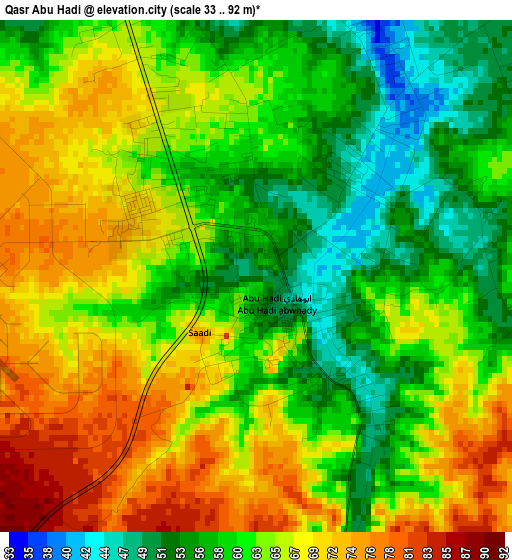
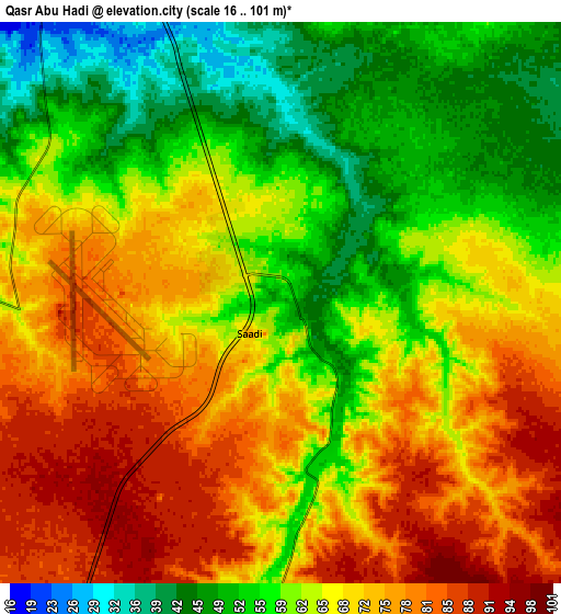
Below is the Elevation map of Qasr Abu Hadi, which displays elevation range with different colors. Scale of the first map is from 33 to 92 m (108 to 302 ft) with average elevation of 63.1 meters (=207 ft) [note 1]
These maps also provides idea of topography and contour of this city, they are displayed at different zoom levels. More info about maps, scale and edge coordinates you can find below images.
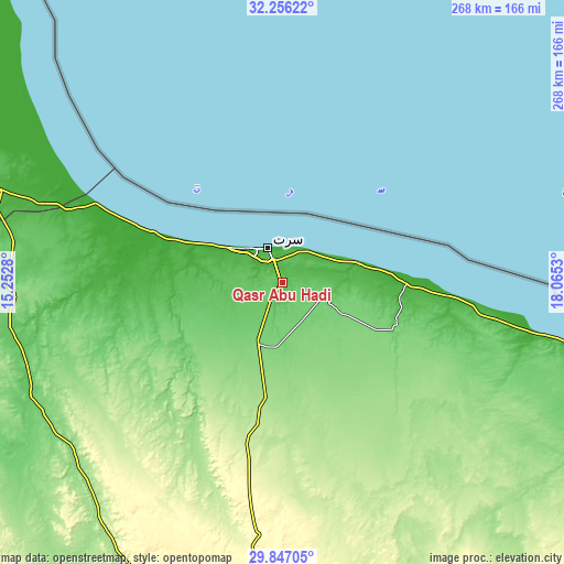
| \ | Map #1 | Map #2 | Topo.Map |
| Scale [m] | 33..92 m | 16..101 m | × |
| Scale [ft] | 108..302 ft | 52..331 ft | × |
| Average | 63.1 m = 207 ft | 65.3 m = 214 ft | × |
| Width | 8.37 km = 5.2 mi | 16.74 km = 10.4 mi | 267.9 km = 166.5 mi |
| Height | 8.37 km = 5.2 mi | 16.74 km = 10.4 mi | 267.9 km = 166.5 mi |
| ↑Max Latitude | 31.096898° | 31.13452° | 32.25622° |
| Latitude at center | 31.05926° | 31.05926° | 31.05926° |
| ↓Min Latitude | 31.021607° | 30.98394° | 29.84705° |
| ← Min Longitude | 16.615105° | 16.571159° | 15.2528° |
| Longitude center | 16.65905° | 16.65905° | 16.65905° |
| →Max Longitude | 16.702995° | 16.746941° | 18.0653° |
Nearby cities:
Cities around Qasr Abu Hadi sort by population:
• Mişrātah elevation 11 m
208.2 km,  314°
314°
• Tarhuna 391 m
324.4 km,  298°
298°
• Al Khums 27 m
287.2 km, 307°
• Sirte 17 m
17.9 km,  338°
338°
• Zliten 9 m
252.1 km, 308°
• Bani Walid 269 m
265.1 km,  286°
286°
• Waddān 251 m
216.9 km,  193°
193°
• Masallātah 236 m
305.1 km, 304°
• Az Zuwaytīnah 7 m
330.1 km,  92°
92°
• Hūn 260 m
225.5 km,  197°
197°
• Al Burayqah 5 m
287.9 km,  104°
104°
• Marādah 39 m
318.9 km,  129°
129°
Multilingual:
 En español:
Qasr Abu Hadi elevación 49 m.
 En France:
Qasr Abu Hadi élévation 49 m.
 Auf Deutsch:
Qasr Abu Hadi höhe über dem Meeresspiegel ist 49 m.

Sources and notes:
- [note 1] Map square and city borders are not equal. Map elevation data is calculated only from area inside that square.
- [src 1] Elevation data from geonames database provided with same terms of usage.
- [src 2] The elevation map of Qasr Abu Hadi is generated using elevation data from NASA's 3 arcsec (90m) resolution SRTM data.
- [src 3] Base (background) map © OpenStreetMap contributors tiles are generated by Geofabrik and OpenTopoMap.
Copyright & License:
This Qasr Abu Hadi Elevation Map is licensed under CC BY-SA. You may reuse any part from this page, if you give a proper credit by linking to this URL:
 More info on terms of use page.