Waddān elevation
Waddān (Al Jufrah), Libya elevation is 251 meters and Waddān elevation in feet is 823 ft above sea level [src 1]. Waddān is a populated place (feature code) with elevation that is 19 meters (62 ft) bigger than average city elevation in Libya.
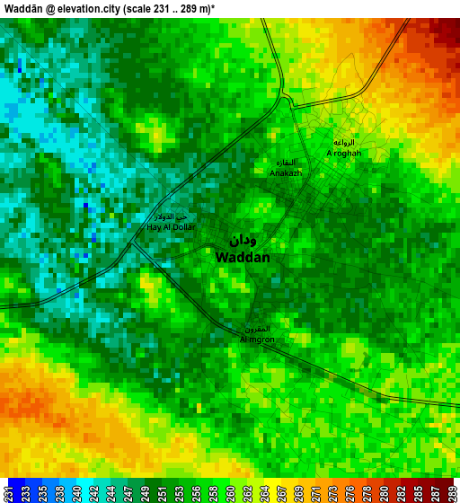
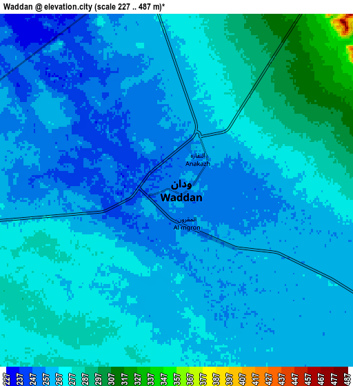
Below is the Elevation map of Waddān, which displays elevation range with different colors. Scale of the first map is from 231 to 289 m (758 to 948 ft) with average elevation of 255.8 meters (=839 ft) [note 1]
These maps also provides idea of topography and contour of this city, they are displayed at different zoom levels. More info about maps, scale and edge coordinates you can find below images.
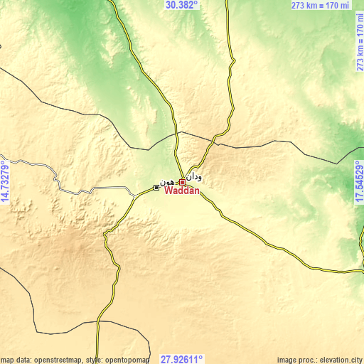
| \ | Map #1 | Map #2 | Topo.Map |
| Scale [m] | 231..289 m | 227..487 m | × |
| Scale [ft] | 758..948 ft | 745..1598 ft | × |
| Average | 255.8 m = 839 ft | 266.3 m = 874 ft | × |
| Width | 8.53 km = 5.3 mi | 17.07 km = 10.6 mi | 273.1 km = 169.7 mi |
| Height | 8.53 km = 5.3 mi | 17.07 km = 10.6 mi | 273.1 km = 169.7 mi |
| ↑Max Latitude | 29.199768° | 29.238122° | 30.382° |
| Latitude at center | 29.1614° | 29.1614° | 29.1614° |
| ↓Min Latitude | 29.123018° | 29.084621° | 27.92611° |
| ← Min Longitude | 16.095095° | 16.051149° | 14.73279° |
| Longitude center | 16.13904° | 16.13904° | 16.13904° |
| →Max Longitude | 16.182985° | 16.226931° | 17.54529° |
Nearby cities:
Cities around Waddān sort by population:
• Mişrātah elevation 11 m
371.1 km,  344°
344°
• Sabhā 421 m
289.7 km,  215°
215°
• Sirte 17 m
231.7 km,  10°
10°
• Al Jadīd 417 m
290.2 km, 215°
• Bani Walid 269 m
353.9 km,  324°
324°
• Brak 349 m
256 km,  225°
225°
• Mizdah 458 m
395.4 km,  310°
310°
• Hūn 260 m
19 km,  258°
258°
• Al Burayqah 5 m
359.2 km,  67°
67°
• Qasr Abu Hadi 49 m
216.9 km, 13°
• Idrī 355 m
357.3 km,  237°
237°
• Marādah 39 m
297.6 km,  88°
88°
Multilingual:
 En español:
Waddān elevación 251 m.
 En France:
Waddān élévation 251 m.


Sources and notes:
- [note 1] Map square and city borders are not equal. Map elevation data is calculated only from area inside that square.
- [src 1] Elevation data from geonames database provided with same terms of usage.
- [src 2] The elevation map of Waddān is generated using elevation data from NASA's 3 arcsec (90m) resolution SRTM data.
- [src 3] Base (background) map © OpenStreetMap contributors tiles are generated by Geofabrik and OpenTopoMap.
Copyright & License:
This Waddān Elevation Map is licensed under CC BY-SA. You may reuse any part from this page, if you give a proper credit by linking to this URL:
 More info on terms of use page.