Clervaux elevation
Clervaux, Luxembourg elevation is 364 meters and Clervaux elevation in feet is 1194 ft above sea level [src 1]. Clervaux is a seat of a second-order administrative division (feature code) with elevation that is 76 meters (249 ft) bigger than average city elevation in Luxembourg.
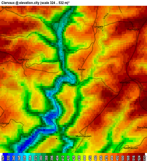
Below is the Elevation map of Clervaux, which displays elevation range with different colors. Scale of the first map is from 324 to 532 m (1063 to 1745 ft) with average elevation of 458.9 meters (=1506 ft) [note 1]
These maps also provides idea of topography and contour of this city, they are displayed at different zoom levels. More info about maps, scale and edge coordinates you can find below images.
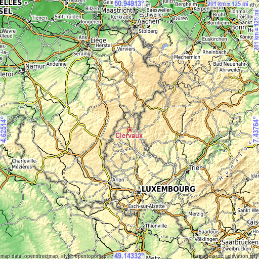
| \ | Map #1 | Topo.Map |
| Scale [m] | 324..532 m | × |
| Scale [ft] | 1063..1745 ft | × |
| Average | 458.9 m = 1506 ft | × |
| Width | 6.27 km = 3.9 mi | 200.8 km = 124.8 mi |
| Height | 6.27 km = 3.9 mi | 200.8 km = 124.8 mi |
| ↑Max Latitude | 50.082927° | 50.94913° |
| Latitude at center | 50.05472° | 50.05472° |
| ↓Min Latitude | 50.026496° | 49.14332° |
| ← Min Longitude | 5.987445° | 4.62514° |
| Longitude center | 6.03139° | 6.03139° |
| →Max Longitude | 6.075335° | 7.43764° |
Nearby cities:
Cities around Clervaux sort by population:
• Wiltz elevation 382 m
12.1 km,  215°
215°
• Vianden 228 m
18.4 km,  136°
136°
• Troisvierges 436 m
7.7 km,  343°
343°
• Hosingen 498 m
6.4 km, 138°
• Weiswampach 492 m
9.7 km,  18°
18°
• Esch-sur-Sûre 282 m
17.3 km,  203°
203°
• Bourscheid 442 m
16.4 km,  170°
170°
• Goesdorf 476 m
15.6 km, 197°
• Wilwerwiltz 299 m
7.7 km, 197°
• Wincrange 490 m
8 km,  268°
268°
• Winseler 334 m
14 km,  226°
226°
• Putscheid 415 m
13.1 km, 142°
Multilingual:
 En español:
Clervaux elevación 364 m.
 En France:
Clervaux élévation 364 m.
 Auf Deutsch:
Clervaux höhe über dem Meeresspiegel ist 364 m.

Sources and notes:
- [note 1] Map square and city borders are not equal. Map elevation data is calculated only from area inside that square.
- [src 1] Elevation data from geonames database provided with same terms of usage.
- [src 2] The elevation map of Clervaux is generated using elevation data from NASA's 3 arcsec (90m) resolution SRTM data.
- [src 3] Base (background) map © OpenStreetMap contributors tiles are generated by Geofabrik and OpenTopoMap.
Copyright & License:
This Clervaux Elevation Map is licensed under CC BY-SA. You may reuse any part from this page, if you give a proper credit by linking to this URL:
 More info on terms of use page.