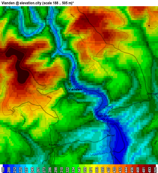
Vianden elevation
Vianden, Luxembourg elevation is 228 meters and Vianden elevation in feet is 748 ft above sea level [src 1]. Vianden is a seat of a second-order administrative division (feature code) with elevation that is 60 meters (197 ft) smaller than average city elevation in Luxembourg.
Below is the Elevation map of Vianden, which displays elevation range with different colors. Scale of the first map is from 188 to 505 m (617 to 1657 ft) with average elevation of 333.7 meters (=1095 ft) [note 1]
These maps also provides idea of topography and contour of this city, they are displayed at different zoom levels. More info about maps, scale and edge coordinates you can find below images.
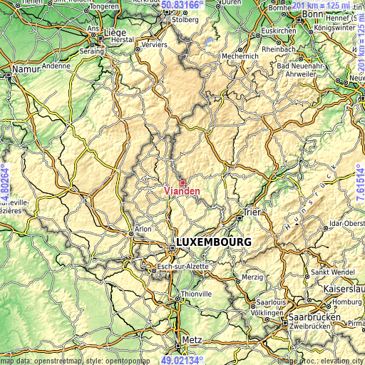
| \ | Map #1 | Topo.Map |
| Scale [m] | 188..505 m | × |
| Scale [ft] | 617..1657 ft | × |
| Average | 333.7 m = 1095 ft | × |
| Width | 6.29 km = 3.9 mi | 201.3 km = 125.1 mi |
| Height | 6.29 km = 3.9 mi | 201.3 km = 125.1 mi |
| ↑Max Latitude | 49.963277° | 50.83166° |
| Latitude at center | 49.935° | 49.935° |
| ↓Min Latitude | 49.906706° | 49.02134° |
| ← Min Longitude | 6.164945° | 4.80264° |
| Longitude center | 6.20889° | 6.20889° |
| →Max Longitude | 6.252835° | 7.61514° |
Nearby cities:
Cities around Vianden sort by population:
• Ettelbruck elevation 199 m
12.3 km,  217°
217°
• Diekirch 195 m
8.4 km,  206°
206°
• Beaufort 357 m
12.5 km,  151°
151°
• Warken 214 m
12.3 km,  226°
226°
• Bettendorf 188 m
6.5 km,  174°
174°
• Medernach 259 m
14 km,  178°
178°
• Erpeldange 207 m
10.3 km, 220°
• Hosingen 498 m
12 km,  315°
315°
• Reisdorf 191 m
8.5 km, 150°
• Bourscheid 442 m
10.5 km,  253°
253°
• Tandel 229 m
4.6 km,  203°
203°
• Putscheid 415 m
5.5 km,  301°
301°
Multilingual:
 En español:
Vianden elevación 228 m.
 En France:
Vianden élévation 228 m.


Sources and notes:
- [note 1] Map square and city borders are not equal. Map elevation data is calculated only from area inside that square.
- [src 1] Elevation data from geonames database provided with same terms of usage.
- [src 2] The elevation map of Vianden is generated using elevation data from NASA's 3 arcsec (90m) resolution SRTM data.
- [src 3] Base (background) map © OpenStreetMap contributors tiles are generated by Geofabrik and OpenTopoMap.
Copyright & License:
This Vianden Elevation Map is licensed under CC BY-SA. You may reuse any part from this page, if you give a proper credit by linking to this URL:
 More info on terms of use page.