Ariogala elevation
Ariogala (Kaunas, Raseiniai), Lithuania elevation is 80 meters and Ariogala elevation in feet is 262 ft above sea level [src 1]. Ariogala is a populated place (feature code) with elevation that is 13 meters (43 ft) smaller than average city elevation in Lithuania.
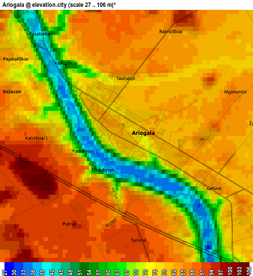
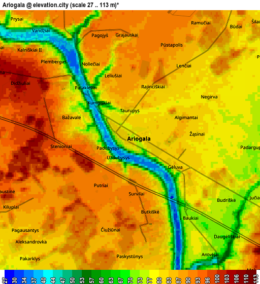
Below is the Elevation map of Ariogala, which displays elevation range with different colors. Scale of the first map is from 27 to 106 m (89 to 348 ft) with average elevation of 78.8 meters (=259 ft) [note 1]
These maps also provides idea of topography and contour of this city, they are displayed at different zoom levels. More info about maps, scale and edge coordinates you can find below images.
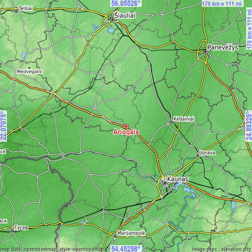
| \ | Map #1 | Map #2 | Topo.Map |
| Scale [m] | 27..106 m | 27..113 m | × |
| Scale [ft] | 89..348 ft | 89..371 ft | × |
| Average | 78.8 m = 259 ft | 82.6 m = 271 ft | × |
| Width | 5.57 km = 3.5 mi | 11.14 km = 6.9 mi | 178.2 km = 110.7 mi |
| Height | 5.57 km = 3.5 mi | 11.14 km = 6.9 mi | 178.2 km = 110.7 mi |
| ↑Max Latitude | 55.287033° | 55.312051° | 56.05526° |
| Latitude at center | 55.262° | 55.262° | 55.262° |
| ↓Min Latitude | 55.236951° | 55.211886° | 54.45258° |
| ← Min Longitude | 23.433055° | 23.389109° | 22.07075° |
| Longitude center | 23.477° | 23.477° | 23.477° |
| →Max Longitude | 23.520945° | 23.564891° | 24.88325° |
Nearby cities:
Cities around Ariogala sort by population:
• Eiguliai elevation 69 m
46.8 km,  141°
141°
• Šilainiai 68 m
45.2 km, 144°
• Kėdainiai 39 m
31.5 km,  84°
84°
• Raseiniai 93 m
25.9 km,  300°
300°
• Šakiai 50 m
43.8 km,  218°
218°
• Akademija (Kaunas) 75 m
46.3 km,  151°
151°
• Tytuvėnėliai 120 m
44.6 km,  334°
334°
• Sargėnai 90 m
43.3 km, 143°
• Vilkija 81 m
25 km,  163°
163°
• Ežerėlis 72 m
42.9 km,  169°
169°
• Gelgaudiškis 53 m
37.8 km,  237°
237°
• Kulautuva 34 m
37.1 km, 163°
Multilingual:
 En español:
Ariogala elevación 80 m.
 En France:
Ariogala élévation 80 m.


Sources and notes:
- [note 1] Map square and city borders are not equal. Map elevation data is calculated only from area inside that square.
- [src 1] Elevation data from geonames database provided with same terms of usage.
- [src 2] The elevation map of Ariogala is generated using elevation data from NASA's 3 arcsec (90m) resolution SRTM data.
- [src 3] Base (background) map © OpenStreetMap contributors tiles are generated by Geofabrik and OpenTopoMap.
Copyright & License:
This Ariogala Elevation Map is licensed under CC BY-SA. You may reuse any part from this page, if you give a proper credit by linking to this URL:
 More info on terms of use page.