Greenville elevation
Greenville (Sinoe), Liberia elevation is 10 meters and Greenville elevation in feet is 33 ft above sea level [src 1]. Greenville is a seat of a first-order administrative division (feature code) with elevation that is 169 meters (554 ft) smaller than average city elevation in Liberia.
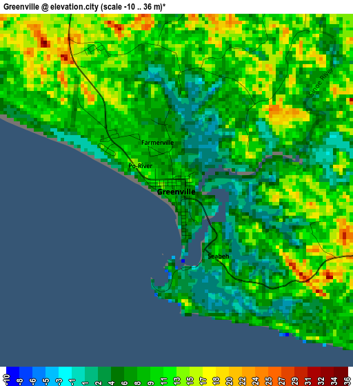
Below is the Elevation map of Greenville, which displays elevation range with different colors. Scale of the first map is from -10 to 36 m (-33 to 118 ft) with average elevation of 9.2 meters (=30 ft) [note 1]
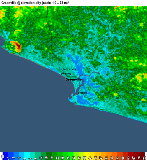
These maps also provides idea of topography and contour of this city, they are displayed at different zoom levels. More info about maps, scale and edge coordinates you can find below images.
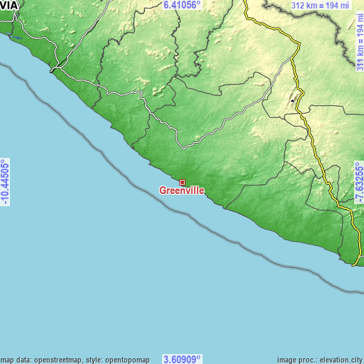
| \ | Map #1 | Map #2 | Topo.Map |
| Scale [m] | -10..36 m | -10..73 m | × |
| Scale [ft] | -33..118 ft | -33..240 ft | × |
| Average | 9.2 m = 30 ft | 16.2 m = 53 ft | × |
| Width | 9.74 km = 6.1 mi | 19.47 km = 12.1 mi | 311.5 km = 193.6 mi |
| Height | 9.74 km = 6.1 mi | 19.47 km = 12.1 mi | 311.5 km = 193.6 mi |
| ↑Max Latitude | 5.055106° | 5.098879° | 6.41056° |
| Latitude at center | 5.01133° | 5.01133° | 5.01133° |
| ↓Min Latitude | 4.967551° | 4.92377° | 3.60909° |
| ← Min Longitude | -9.082745° | -9.126691° | -10.44505° |
| Longitude center | -9.0388° | -9.0388° | -9.0388° |
| →Max Longitude | -8.994855° | -8.950909° | -7.63255° |
Nearby cities:
Cities around Greenville sort by population:
• Monrovia elevation 32 m
241.6 km,  306°
306°
• Gbarnga 253 m
225.7 km,  347°
347°
• Kakata 97 m
223 km,  319°
319°
• Bensonville 54 m
236.2 km, 312°
• Harper 14 m
163.1 km,  115°
115°
• Buchanan 78 m
147.6 km, 310°
• Zwedru 221 m
154.3 km,  40°
40°
• Ganta 408 m
260.8 km,  12°
12°
• Fish Town 199 m
130.5 km,  80°
80°
• Barclayville 20 m
96.8 km,  112°
112°
• Cestos City 5 m
77.9 km, 309°
• Buutuo 247 m
216.1 km,  20°
20°
Multilingual:
 En español:
Greenville elevación 10 m.
 En France:
Greenville élévation 10 m.
 Auf Deutsch:
Greenville höhe über dem Meeresspiegel ist 10 m.

Sources and notes:
- [note 1] Map square and city borders are not equal. Map elevation data is calculated only from area inside that square.
- [src 1] Elevation data from geonames database provided with same terms of usage.
- [src 2] The elevation map of Greenville is generated using elevation data from NASA's 3 arcsec (90m) resolution SRTM data.
- [src 3] Base (background) map © OpenStreetMap contributors tiles are generated by Geofabrik and OpenTopoMap.
Copyright & License:
This Greenville Elevation Map is licensed under CC BY-SA. You may reuse any part from this page, if you give a proper credit by linking to this URL:
 More info on terms of use page.