Gbarnga elevation
Gbarnga (Bong), Liberia elevation is 253 meters and Gbarnga elevation in feet is 830 ft above sea level [src 1]. Gbarnga is a seat of a first-order administrative division (feature code) with elevation that is 74 meters (243 ft) bigger than average city elevation in Liberia.
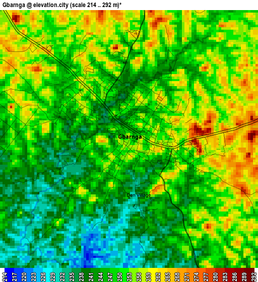
Below is the Elevation map of Gbarnga, which displays elevation range with different colors. Scale of the first map is from 214 to 292 m (702 to 958 ft) with average elevation of 248.6 meters (=816 ft) [note 1]
These maps also provides idea of topography and contour of this city, they are displayed at different zoom levels. More info about maps, scale and edge coordinates you can find below images.
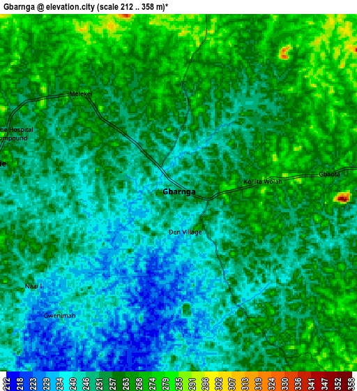
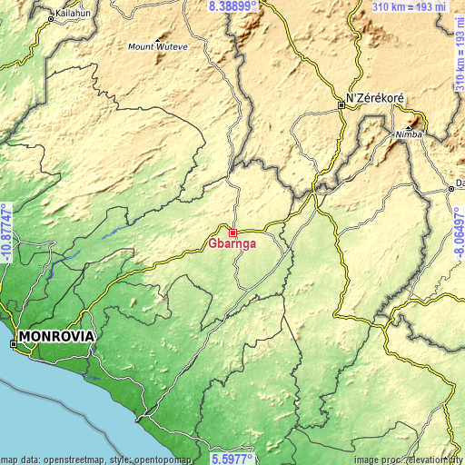
| \ | Map #1 | Map #2 | Topo.Map |
| Scale [m] | 214..292 m | 212..358 m | × |
| Scale [ft] | 702..958 ft | 696..1175 ft | × |
| Average | 248.6 m = 816 ft | 254.4 m = 835 ft | × |
| Width | 9.7 km = 6 mi | 19.4 km = 12.1 mi | 310.4 km = 192.9 mi |
| Height | 9.7 km = 6 mi | 19.4 km = 12.1 mi | 310.4 km = 192.9 mi |
| ↑Max Latitude | 7.039046° | 7.082658° | 8.38899° |
| Latitude at center | 6.99543° | 6.99543° | 6.99543° |
| ↓Min Latitude | 6.95181° | 6.908186° | 5.5977° |
| ← Min Longitude | -9.515165° | -9.559111° | -10.87747° |
| Longitude center | -9.47122° | -9.47122° | -9.47122° |
| →Max Longitude | -9.427275° | -9.383329° | -8.06497° |
Nearby cities:
Cities around Gbarnga sort by population:
• Monrovia elevation 32 m
165.5 km,  242°
242°
• Kakata 97 m
110.3 km, 242°
• Bensonville 54 m
140 km, 244°
• Voinjama 550 m
161.5 km,  349°
349°
• Buchanan 78 m
139.8 km,  207°
207°
• New Yekepa 510 m
121.7 km,  57°
57°
• Ganta 408 m
109.2 km,  71°
71°
• Sanniquellie 430 m
93 km, 64°
• Tubmanburg 71 m
149.6 km,  264°
264°
• Bopolu 179 m
112.4 km,  274°
274°
• Cestos City 5 m
171.5 km,  184°
184°
• Buutuo 247 m
125.9 km,  98°
98°
Multilingual:
 En español:
Gbarnga elevación 253 m.
 En France:
Gbarnga élévation 253 m.


Sources and notes:
- [note 1] Map square and city borders are not equal. Map elevation data is calculated only from area inside that square.
- [src 1] Elevation data from geonames database provided with same terms of usage.
- [src 2] The elevation map of Gbarnga is generated using elevation data from NASA's 3 arcsec (90m) resolution SRTM data.
- [src 3] Base (background) map © OpenStreetMap contributors tiles are generated by Geofabrik and OpenTopoMap.
Copyright & License:
This Gbarnga Elevation Map is licensed under CC BY-SA. You may reuse any part from this page, if you give a proper credit by linking to this URL:
 More info on terms of use page.