Ratnapura elevation
Ratnapura (Sabaragamuwa), Sri Lanka elevation is 149 meters and Ratnapura elevation in feet is 489 ft above sea level [src 1]. Ratnapura is a seat of a first-order administrative division (feature code) with elevation that is 8 meters (26 ft) smaller than average city elevation in Sri Lanka.
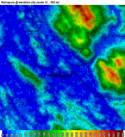
Below is the Elevation map of Ratnapura, which displays elevation range with different colors. Scale of the first map is from 12 to 553 m (39 to 1814 ft) with average elevation of 96 meters (=315 ft) [note 1]
These maps also provides idea of topography and contour of this city, they are displayed at different zoom levels. More info about maps, scale and edge coordinates you can find below images.
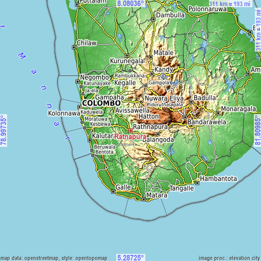
| \ | Map #1 | Map #2 | Topo.Map |
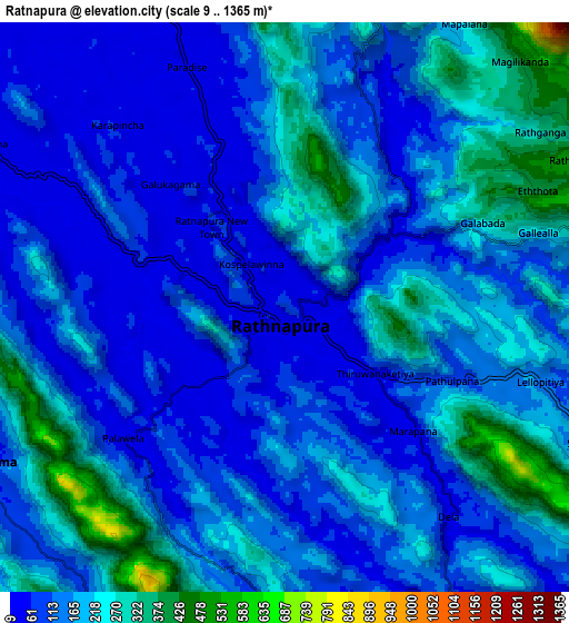
| Scale [m] | 12..553 m | 9..1365 m | × |
| Scale [ft] | 39..1814 ft | 30..4478 ft | × |
| Average | 96 m = 315 ft | 157.2 m = 516 ft | × |
| Width | 9.71 km = 6 mi | 19.41 km = 12.1 mi | 310.6 km = 193 mi |
| Height | 9.71 km = 6 mi | 19.41 km = 12.1 mi | 310.6 km = 193 mi |
| ↑Max Latitude | 6.729445° | 6.773085° | 8.08036° |
| Latitude at center | 6.6858° | 6.6858° | 6.6858° |
| ↓Min Latitude | 6.642152° | 6.598499° | 5.28725° |
| ← Min Longitude | 80.359655° | 80.315709° | 78.99735° |
| Longitude center | 80.4036° | 80.4036° | 80.4036° |
| →Max Longitude | 80.447545° | 80.491491° | 81.80985° |
Nearby cities:
Cities around Ratnapura sort by population:
• Maharagama elevation 26 m
55.7 km,  288°
288°
• Kalutara 7 m
50.4 km,  256°
256°
• Bentota 8 m
53.5 km,  237°
237°
• Homagama 37 m
47.7 km, 291°
• Beruwala 12 m
51.9 km, 243°
• Panadura 10 m
55.4 km,  273°
273°
• Nuwara Eliya 1868 m
52.5 km,  52°
52°
• Hanwella Ihala 14 m
42.5 km,  304°
304°
• Hatton 1309 m
31.2 km,  42°
42°
• Horana South 23 m
37.8 km,  275°
275°
• Horawala Junction 15 m
38.1 km,  233°
233°
• Talawakele 1217 m
39.6 km, 45°
Multilingual:
 En español:
Ratnapura elevación 149 m.
 En France:
Ratnapura élévation 149 m.
 Auf Deutsch:
Ratnapura höhe über dem Meeresspiegel ist 149 m.
 На русском:
Ратнапуры, Ратнапура высота над уровнем моря 149 м
Sources and notes:
- [note 1] Map square and city borders are not equal. Map elevation data is calculated only from area inside that square.
- [src 1] Elevation data from geonames database provided with same terms of usage.
- [src 2] The elevation map of Ratnapura is generated using elevation data from NASA's 3 arcsec (90m) resolution SRTM data.
- [src 3] Base (background) map © OpenStreetMap contributors tiles are generated by Geofabrik and OpenTopoMap.
Copyright & License:
This Ratnapura Elevation Map is licensed under CC BY-SA. You may reuse any part from this page, if you give a proper credit by linking to this URL:
 More info on terms of use page.