Batroûn elevation
Batroûn (Liban-Nord), Lebanon elevation is 13 meters and Batroûn elevation in feet is 43 ft above sea level [src 1]. Batroûn is a seat of a second-order administrative division (feature code) with elevation that is 542 meters (1778 ft) smaller than average city elevation in Lebanon.
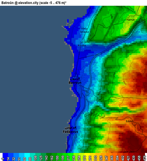
Below is the Elevation map of Batroûn, which displays elevation range with different colors. Scale of the first map is from -5 to 476 m (-16 to 1562 ft) with average elevation of 192.9 meters (=633 ft) [note 1]
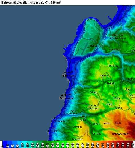
These maps also provides idea of topography and contour of this city, they are displayed at different zoom levels. More info about maps, scale and edge coordinates you can find below images.
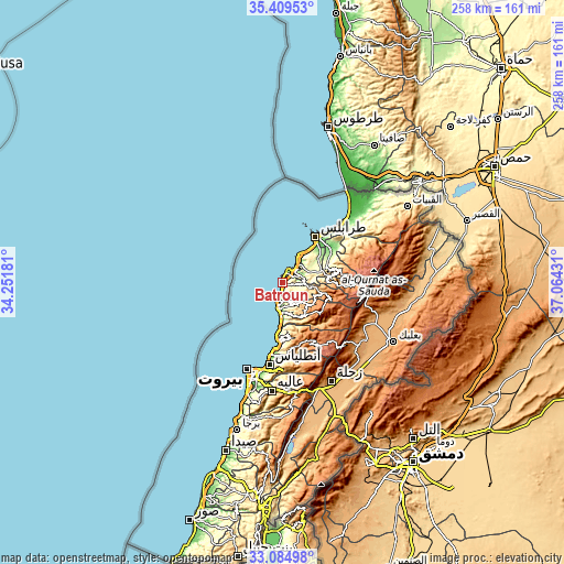
| \ | Map #1 | Map #2 | Topo.Map |
| Scale [m] | -5..476 m | -7..796 m | × |
| Scale [ft] | -16..1562 ft | -23..2612 ft | × |
| Average | 192.9 m = 633 ft | 277.6 m = 911 ft | × |
| Width | 8.08 km = 5 mi | 16.15 km = 10 mi | 258.5 km = 160.6 mi |
| Height | 8.08 km = 5 mi | 16.15 km = 10 mi | 258.5 km = 160.6 mi |
| ↑Max Latitude | 34.291595° | 34.327894° | 35.40953° |
| Latitude at center | 34.25528° | 34.25528° | 34.25528° |
| ↓Min Latitude | 34.21895° | 34.182604° | 33.08498° |
| ← Min Longitude | 35.614115° | 35.570169° | 34.25181° |
| Longitude center | 35.65806° | 35.65806° | 35.65806° |
| →Max Longitude | 35.702005° | 35.745951° | 37.06431° |
Nearby cities:
Cities around Batroûn sort by population:
• Beirut elevation 40 m
42.7 km,  199°
199°
• Ra’s Bayrūt 35 m
42.7 km, 202°
• Tripoli 51 m
26.2 km,  40°
40°
• Jounieh 40 m
30.7 km,  186°
186°
• Jbaïl 33 m
14.9 km,  183°
183°
• Bcharré 1442 m
32.4 km,  90°
90°
• Baabda 215 m
48 km, 192°
• Bhamdoûn el Mhatta 1083 m
49.7 km, 179°
• Jdaidet el Matn 32 m
41.4 km, 191°
• Sîr ed Danniyé 940 m
37.2 km,  67°
67°
• Zghartā 126 m
26.9 km,  54°
54°
• Amioûn 343 m
14.7 km, 70°
Multilingual:
 En español:
Batroûn elevación 13 m.
 En France:
Batroûn élévation 13 m.


Sources and notes:
- [note 1] Map square and city borders are not equal. Map elevation data is calculated only from area inside that square.
- [src 1] Elevation data from geonames database provided with same terms of usage.
- [src 2] The elevation map of Batroûn is generated using elevation data from NASA's 3 arcsec (90m) resolution SRTM data.
- [src 3] Base (background) map © OpenStreetMap contributors tiles are generated by Geofabrik and OpenTopoMap.
Copyright & License:
This Batroûn Elevation Map is licensed under CC BY-SA. You may reuse any part from this page, if you give a proper credit by linking to this URL:
 More info on terms of use page.