Beirut elevation
Beirut (Beyrouth), Lebanon elevation is 40 meters and Beirut elevation in feet is 131 ft above sea level [src 1]. Beirut is a capital of a political entity (feature code) with elevation that is 515 meters (1690 ft) smaller than average city elevation in Lebanon.
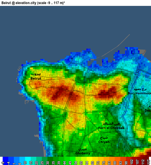
Below is the Elevation map of Beirut, which displays elevation range with different colors. Scale of the first map is from -9 to 117 m (-30 to 384 ft) with average elevation of 41.9 meters (=137 ft) [note 1]
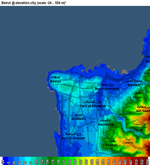
These maps also provides idea of topography and contour of this city, they are displayed at different zoom levels. More info about maps, scale and edge coordinates you can find below images.
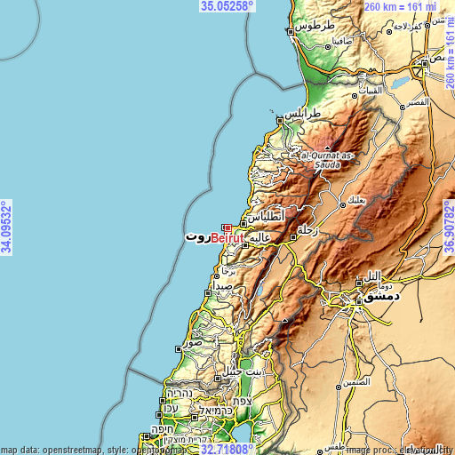
| \ | Map #1 | Map #2 | Topo.Map |
| Scale [m] | -9..117 m | -24..554 m | × |
| Scale [ft] | -30..384 ft | -79..1818 ft | × |
| Average | 41.9 m = 137 ft | 100 m = 328 ft | × |
| Width | 8.11 km = 5 mi | 16.22 km = 10.1 mi | 259.6 km = 161.3 mi |
| Height | 8.11 km = 5 mi | 16.22 km = 10.1 mi | 259.6 km = 161.3 mi |
| ↑Max Latitude | 33.92979° | 33.966245° | 35.05258° |
| Latitude at center | 33.89332° | 33.89332° | 33.89332° |
| ↓Min Latitude | 33.856834° | 33.820333° | 32.71808° |
| ← Min Longitude | 35.457625° | 35.413679° | 34.09532° |
| Longitude center | 35.50157° | 35.50157° | 35.50157° |
| →Max Longitude | 35.545515° | 35.589461° | 36.90782° |
Nearby cities:
Cities around Beirut sort by population:
• Ra’s Bayrūt elevation 35 m
1.8 km,  293°
293°
• Sidon 9 m
39.2 km,  197°
197°
• Jounieh 40 m
14.5 km,  47°
47°
• Zahlé 963 m
37.3 km,  97°
97°
• Jbaïl 33 m
28.7 km,  28°
28°
• Baabda 215 m
7.7 km,  149°
149°
• Bhamdoûn el Mhatta 1083 m
17.4 km,  122°
122°
• Bhamdoun 1145 m
17.6 km,  128°
128°
• Joubb Jannîne 945 m
39.5 km,  138°
138°
• Beït ed Dîne 859 m
23.3 km,  161°
161°
• Aaley 878 m
13.4 km, 137°
• Jdaidet el Matn 32 m
6 km,  92°
92°
Multilingual:
 En español:
Beirut elevación 40 m.
 En France:
Beyrouth élévation 40 m.


Sources and notes:
- [note 1] Map square and city borders are not equal. Map elevation data is calculated only from area inside that square.
- [src 1] Elevation data from geonames database provided with same terms of usage.
- [src 2] The elevation map of Beirut is generated using elevation data from NASA's 3 arcsec (90m) resolution SRTM data.
- [src 3] Base (background) map © OpenStreetMap contributors tiles are generated by Geofabrik and OpenTopoMap.
Copyright & License:
This Beirut Elevation Map is licensed under CC BY-SA. You may reuse any part from this page, if you give a proper credit by linking to this URL:
 More info on terms of use page.