Xam Nua elevation
Xam Nua (Houaphan), Laos elevation is 967 meters and Xam Nua elevation in feet is 3173 ft above sea level [src 1]. Xam Nua is a seat of a first-order administrative division (feature code) with elevation that is 493 meters (1617 ft) bigger than average city elevation in Laos.
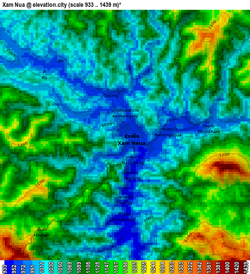
Below is the Elevation map of Xam Nua, which displays elevation range with different colors. Scale of the first map is from 933 to 1439 m (3061 to 4721 ft) with average elevation of 1080.5 meters (=3545 ft) [note 1]
These maps also provides idea of topography and contour of this city, they are displayed at different zoom levels. More info about maps, scale and edge coordinates you can find below images.
| \ | Map #1 | Map #2 | Topo.Map |
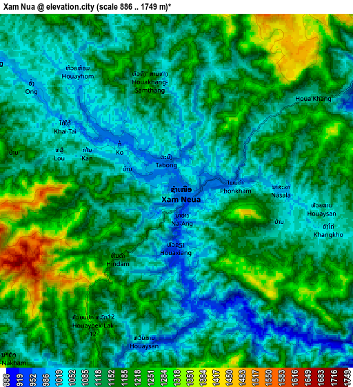
| Scale [m] | 933..1439 m | 886..1749 m | × |
| Scale [ft] | 3061..4721 ft | 2907..5738 ft | × |
| Average | 1080.5 m = 3545 ft | 1141.5 m = 3745 ft | × |
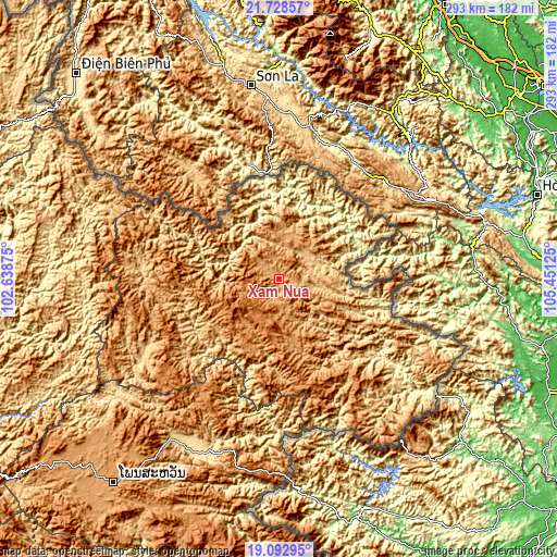
| Width | 9.16 km = 5.7 mi | 18.32 km = 11.4 mi | 293.1 km = 182.1 mi |
| Height | 9.16 km = 5.7 mi | 18.32 km = 11.4 mi | 293.1 km = 182.1 mi |
| ↑Max Latitude | 20.457579° | 20.498747° | 21.72857° |
| Latitude at center | 20.4164° | 20.4164° | 20.4164° |
| ↓Min Latitude | 20.37521° | 20.334008° | 19.09295° |
| ← Min Longitude | 104.001055° | 103.957109° | 102.63875° |
| Longitude center | 104.045° | 104.045° | 104.045° |
| →Max Longitude | 104.088945° | 104.132891° | 105.45125° |
Nearby cities:
Cities around Xam Nua sort by population:
• Luang Prabang elevation 300 m
207.9 km,  253°
253°
• Muang Phônsavan 1119 m
139.7 km,  219°
219°
• Ban Xiang-Ngeun 318 m
207.8 km, 249°
• Ban Pakla 472 m
207.4 km,  284°
284°
• Khoa 394 m
176.1 km,  294°
294°
• Muang Mok 920 m
167.5 km,  181°
181°
• Ban Namnga 413 m
160.8 km,  301°
301°
• Xamtay 1722 m
71.9 km,  136°
136°
• Viengthong 1313 m
67.1 km,  261°
261°
• Huameung 1440 m
35.5 km,  213°
213°
• Viengxay 662 m
32.3 km,  104°
104°
• Viangxai 882 m
18.7 km,  93°
93°
Multilingual:
 En español:
Xam Nua elevación 967 m.
 En France:
Xam Nua élévation 967 m.


Sources and notes:
- [note 1] Map square and city borders are not equal. Map elevation data is calculated only from area inside that square.
- [src 1] Elevation data from geonames database provided with same terms of usage.
- [src 2] The elevation map of Xam Nua is generated using elevation data from NASA's 3 arcsec (90m) resolution SRTM data.
- [src 3] Base (background) map © OpenStreetMap contributors tiles are generated by Geofabrik and OpenTopoMap.
Copyright & License:
This Xam Nua Elevation Map is licensed under CC BY-SA. You may reuse any part from this page, if you give a proper credit by linking to this URL:
 More info on terms of use page.