Xamtay elevation
Xamtay (Houaphan), Laos elevation is 1722 meters and Xamtay elevation in feet is 5650 ft above sea level [src 1]. Xamtay is a seat of a second-order administrative division (feature code) with elevation that is 1248 meters (4094 ft) bigger than average city elevation in Laos.
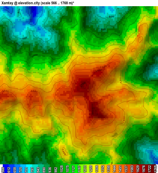
Below is the Elevation map of Xamtay, which displays elevation range with different colors. Scale of the first map is from 566 to 1768 m (1857 to 5801 ft) with average elevation of 1190.9 meters (=3907 ft) [note 1]
These maps also provides idea of topography and contour of this city, they are displayed at different zoom levels. More info about maps, scale and edge coordinates you can find below images.
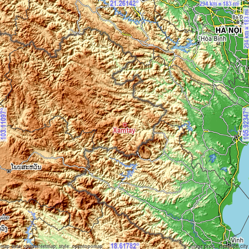
| \ | Map #1 | Topo.Map |
| Scale [m] | 566..1768 m | × |
| Scale [ft] | 1857..5801 ft | × |
| Average | 1190.9 m = 3907 ft | × |
| Width | 9.19 km = 5.7 mi | 293.9 km = 182.6 mi |
| Height | 9.19 km = 5.7 mi | 294 km = 182.7 mi |
| ↑Max Latitude | 19.986454° | 21.26142° |
| Latitude at center | 19.94515° | 19.94515° |
| ↓Min Latitude | 19.903835° | 18.61782° |
| ← Min Longitude | 104.473275° | 103.11097° |
| Longitude center | 104.51722° | 104.51722° |
| →Max Longitude | 104.561165° | 105.92347° |
Nearby cities:
Cities around Xamtay sort by population:
• Xam Nua elevation 967 m
71.9 km,  316°
316°
• Muang Phônsavan 1119 m
149.3 km,  248°
248°
• Pakxan 147 m
194.5 km,  207°
207°
• Ban Nahin 162 m
192 km,  189°
189°
• Muang Khamkeut 430 m
192.5 km,  173°
173°
• Pakkading 158 m
188.4 km,  196°
196°
• Borikhan 165 m
174.7 km, 208°
• Muang Mok 920 m
127 km, 204°
• Viengthong 1313 m
123.3 km,  290°
290°
• Huameung 1440 m
72.4 km, 288°
• Viangxai 882 m
59.8 km,  329°
329°
• Viengxay 662 m
47.7 km,  337°
337°
Multilingual:
 En español:
Xamtay elevación 1722 m.
 En France:
Xamtay élévation 1722 m.


Sources and notes:
- [note 1] Map square and city borders are not equal. Map elevation data is calculated only from area inside that square.
- [src 1] Elevation data from geonames database provided with same terms of usage.
- [src 2] The elevation map of Xamtay is generated using elevation data from NASA's 3 arcsec (90m) resolution SRTM data.
- [src 3] Base (background) map © OpenStreetMap contributors tiles are generated by Geofabrik and OpenTopoMap.
Copyright & License:
This Xamtay Elevation Map is licensed under CC BY-SA. You may reuse any part from this page, if you give a proper credit by linking to this URL:
 More info on terms of use page.