Glubokoye elevation
Glubokoye (East Kazakhstan), Kazakhstan elevation is 277 meters and Glubokoye elevation in feet is 909 ft above sea level [src 1]. Glubokoye is a populated place (feature code) with elevation that is 81 meters (266 ft) smaller than average city elevation in Kazakhstan.
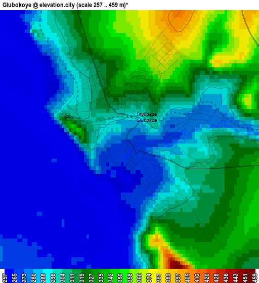
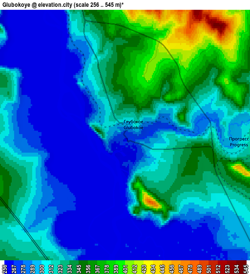
Below is the Elevation map of Glubokoye, which displays elevation range with different colors. Scale of the first map is from 257 to 459 m (843 to 1506 ft) with average elevation of 301.7 meters (=990 ft) [note 1]
These maps also provides idea of topography and contour of this city, they are displayed at different zoom levels. More info about maps, scale and edge coordinates you can find below images.
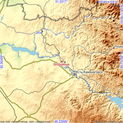
| \ | Map #1 | Map #2 | Topo.Map |
| Scale [m] | 257..459 m | 256..545 m | × |
| Scale [ft] | 843..1506 ft | 840..1788 ft | × |
| Average | 301.7 m = 990 ft | 312.4 m = 1025 ft | × |
| Width | 6.26 km = 3.9 mi | 12.53 km = 7.8 mi | 200.4 km = 124.5 mi |
| Height | 6.26 km = 3.9 mi | 12.53 km = 7.8 mi | 200.4 km = 124.5 mi |
| ↑Max Latitude | 50.167028° | 50.195168° | 51.0317° |
| Latitude at center | 50.13887° | 50.13887° | 50.13887° |
| ↓Min Latitude | 50.110696° | 50.082505° | 49.22906° |
| ← Min Longitude | 82.267195° | 82.223249° | 80.90489° |
| Longitude center | 82.31114° | 82.31114° | 82.31114° |
| →Max Longitude | 82.355085° | 82.399031° | 83.71739° |
Nearby cities:
Cities around Glubokoye sort by population:
• Ust-Kamenogorsk elevation 287 m
28.1 km,  131°
131°
• Ridder 741 m
88.5 km,  75°
75°
• Shemonaīkha 313 m
61.3 km,  332°
332°
• Belousovka 365 m
15.2 km,  92°
92°
• Ūst’-Talovka 302 m
56.2 km,  324°
324°
• Zhanga Buqtyrma 418 m
103.8 km,  123°
123°
• Asūbulaq 645 m
84.2 km,  140°
140°
• Auezov 402 m
70.8 km,  227°
227°
• Altayskiy 380 m
12.5 km,  17°
17°
• Ognevka 369 m
71.5 km, 135°
• Belogorskīy 973 m
95 km, 140°
• Suykbulak 363 m
102.3 km,  242°
242°
Multilingual:
 En español:
Glubokoye elevación 277 m.
 En France:
Glubokoye élévation 277 m.
 Auf Deutsch:
Glubokoye höhe über dem Meeresspiegel ist 277 m.

Sources and notes:
- [note 1] Map square and city borders are not equal. Map elevation data is calculated only from area inside that square.
- [src 1] Elevation data from geonames database provided with same terms of usage.
- [src 2] The elevation map of Glubokoye is generated using elevation data from NASA's 3 arcsec (90m) resolution SRTM data.
- [src 3] Base (background) map © OpenStreetMap contributors tiles are generated by Geofabrik and OpenTopoMap.
Copyright & License:
This Glubokoye Elevation Map is licensed under CC BY-SA. You may reuse any part from this page, if you give a proper credit by linking to this URL:
 More info on terms of use page.