Ridder elevation
Ridder (East Kazakhstan), Kazakhstan elevation is 741 meters and Ridder elevation in feet is 2431 ft above sea level [src 1]. Ridder is a populated place (feature code) with elevation that is 383 meters (1257 ft) bigger than average city elevation in Kazakhstan.
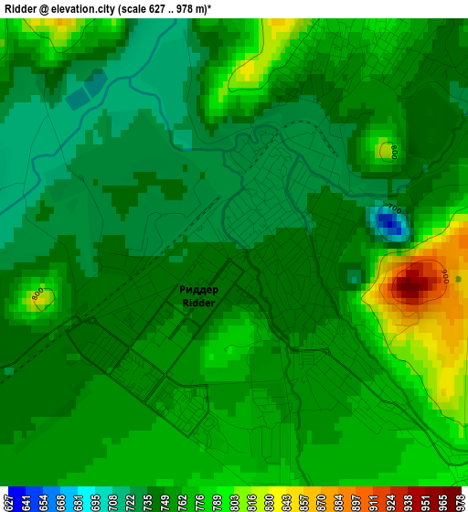
Below is the Elevation map of Ridder, which displays elevation range with different colors. Scale of the first map is from 627 to 978 m (2057 to 3209 ft) with average elevation of 756.2 meters (=2481 ft) [note 1]
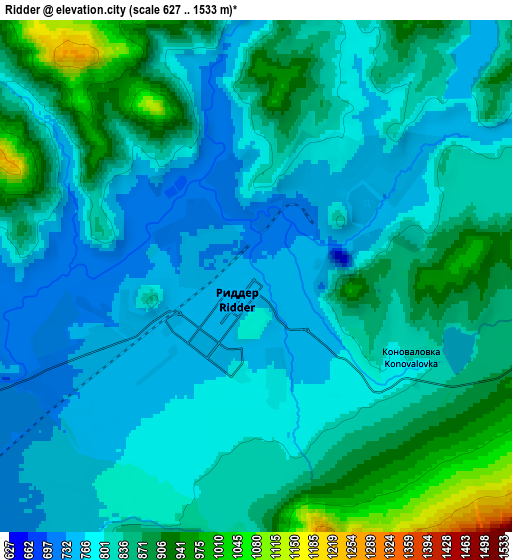
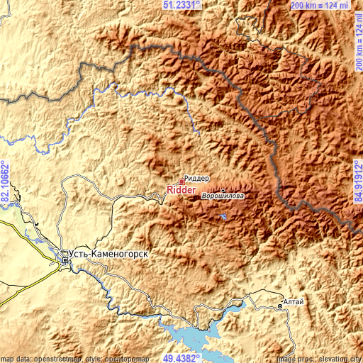
These maps also provides idea of topography and contour of this city, they are displayed at different zoom levels. More info about maps, scale and edge coordinates you can find below images.
| \ | Map #1 | Map #2 | Topo.Map |
| Scale [m] | 627..978 m | 627..1533 m | × |
| Scale [ft] | 2057..3209 ft | 2057..5030 ft | × |
| Average | 756.2 m = 2481 ft | 825.9 m = 2710 ft | × |
| Width | 6.24 km = 3.9 mi | 12.47 km = 7.7 mi | 199.6 km = 124 mi |
| Height | 6.24 km = 3.9 mi | 12.47 km = 7.7 mi | 199.6 km = 124 mi |
| ↑Max Latitude | 50.372167° | 50.400186° | 51.2331° |
| Latitude at center | 50.34413° | 50.34413° | 50.34413° |
| ↓Min Latitude | 50.316077° | 50.288007° | 49.4382° |
| ← Min Longitude | 83.468925° | 83.424979° | 82.10662° |
| Longitude center | 83.51287° | 83.51287° | 83.51287° |
| →Max Longitude | 83.556815° | 83.600761° | 84.91912° |
Nearby cities:
Cities around Ridder sort by population:
• Ust-Kamenogorsk elevation 287 m
76.8 km,  237°
237°
• Zyryanovsk 471 m
87.5 km,  141°
141°
• Shemonaīkha 313 m
117.6 km,  285°
285°
• Glubokoye 277 m
88.5 km,  255°
255°
• Belousovka 365 m
74.1 km,  251°
251°
• Zhanga Buqtyrma 418 m
79.5 km,  179°
179°
• Asūbulaq 645 m
93.2 km,  200°
200°
• Altayskiy 380 m
82.4 km, 262°
• Maleyevsk 433 m
80.9 km, 136°
• Pervorosiyskiy 412 m
73.8 km,  161°
161°
• Ognevka 369 m
81.6 km,  205°
205°
• Belogorskīy 973 m
99.9 km, 195°
Multilingual:
 En español:
Ridder elevación 741 m.
 En France:
Ridder élévation 741 m.
 Auf Deutsch:
Ridder höhe über dem Meeresspiegel ist 741 m.
 На русском:
Лениногорск, Риддер высота над уровнем моря 741 м
Sources and notes:
- [note 1] Map square and city borders are not equal. Map elevation data is calculated only from area inside that square.
- [src 1] Elevation data from geonames database provided with same terms of usage.
- [src 2] The elevation map of Ridder is generated using elevation data from NASA's 3 arcsec (90m) resolution SRTM data.
- [src 3] Base (background) map © OpenStreetMap contributors tiles are generated by Geofabrik and OpenTopoMap.
Copyright & License:
This Ridder Elevation Map is licensed under CC BY-SA. You may reuse any part from this page, if you give a proper credit by linking to this URL:
 More info on terms of use page.