Kentau elevation
Kentau (South Kazakhstan), Kazakhstan elevation is 426 meters and Kentau elevation in feet is 1398 ft above sea level [src 1]. Kentau is a populated place (feature code) with elevation that is 68 meters (223 ft) bigger than average city elevation in Kazakhstan.
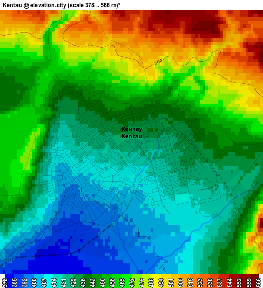
Below is the Elevation map of Kentau, which displays elevation range with different colors. Scale of the first map is from 378 to 566 m (1240 to 1857 ft) with average elevation of 448.1 meters (=1470 ft) [note 1]
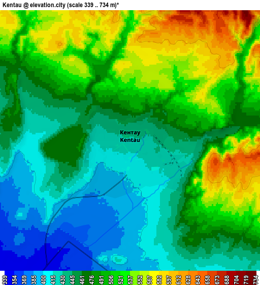
These maps also provides idea of topography and contour of this city, they are displayed at different zoom levels. More info about maps, scale and edge coordinates you can find below images.
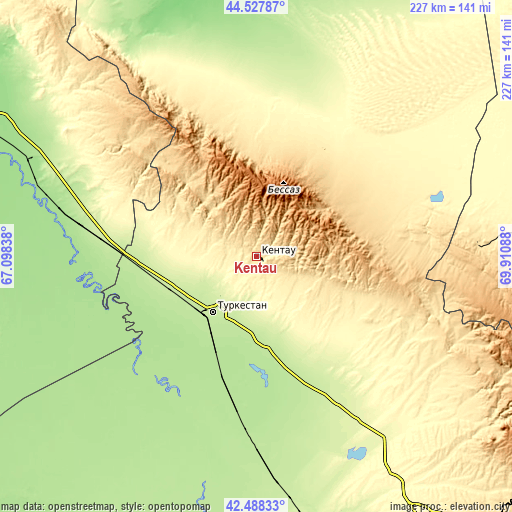
| \ | Map #1 | Map #2 | Topo.Map |
| Scale [m] | 378..566 m | 339..734 m | × |
| Scale [ft] | 1240..1857 ft | 1112..2408 ft | × |
| Average | 448.1 m = 1470 ft | 479.1 m = 1572 ft | × |
| Width | 7.09 km = 4.4 mi | 14.17 km = 8.8 mi | 226.8 km = 140.9 mi |
| Height | 7.09 km = 4.4 mi | 14.17 km = 8.8 mi | 226.8 km = 140.9 mi |
| ↑Max Latitude | 43.54858° | 43.580422° | 44.52787° |
| Latitude at center | 43.51672° | 43.51672° | 43.51672° |
| ↓Min Latitude | 43.484844° | 43.45295° | 42.48833° |
| ← Min Longitude | 68.460685° | 68.416739° | 67.09838° |
| Longitude center | 68.50463° | 68.50463° | 68.50463° |
| →Max Longitude | 68.548575° | 68.592521° | 69.91088° |
Nearby cities:
Cities around Kentau sort by population:
• Turkestan elevation 214 m
31.8 km,  219°
219°
• Arys 239 m
123.3 km,  168°
168°
• Zhangatas 511 m
99.2 km,  87°
87°
• Yanykurgan 166 m
110 km,  293°
293°
• Temirlanovka 291 m
118.9 km,  149°
149°
• Chulakkurgan 472 m
60.8 km,  63°
63°
• Kantagi 470 m
6.4 km,  78°
78°
• Chayan 381 m
88.9 km,  127°
127°
• Ashchysay 816 m
32 km, 82°
• Shalqīya 235 m
103.5 km,  301°
301°
• Bayzhansay 870 m
120.5 km,  108°
108°
• Qogham 195 m
78.7 km,  193°
193°
Multilingual:
 En español:
Kentau elevación 426 m.
 En France:
Kentaou élévation 426 m.


Sources and notes:
- [note 1] Map square and city borders are not equal. Map elevation data is calculated only from area inside that square.
- [src 1] Elevation data from geonames database provided with same terms of usage.
- [src 2] The elevation map of Kentau is generated using elevation data from NASA's 3 arcsec (90m) resolution SRTM data.
- [src 3] Base (background) map © OpenStreetMap contributors tiles are generated by Geofabrik and OpenTopoMap.
Copyright & License:
This Kentau Elevation Map is licensed under CC BY-SA. You may reuse any part from this page, if you give a proper credit by linking to this URL:
 More info on terms of use page.