Kyzylorda elevation
Kyzylorda (Qyzylorda), Kazakhstan elevation is 128 meters and Kyzylorda elevation in feet is 420 ft above sea level [src 1]. Kyzylorda is a seat of a first-order administrative division (feature code) with elevation that is 230 meters (755 ft) smaller than average city elevation in Kazakhstan.
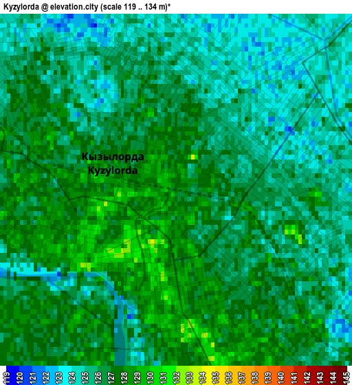
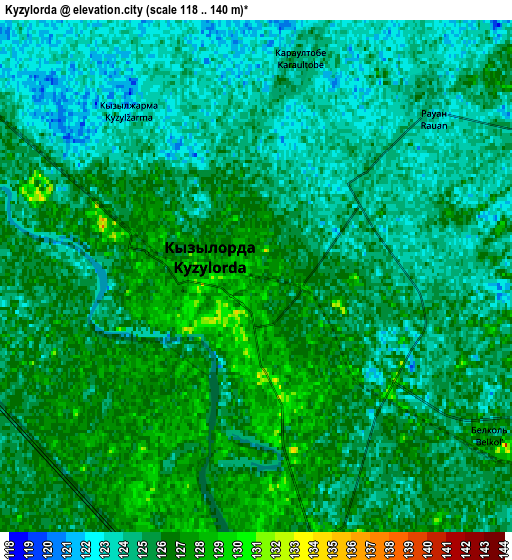
Below is the Elevation map of Kyzylorda, which displays elevation range with different colors. Scale of the first map is from 119 to 134 m (390 to 440 ft) with average elevation of 126 meters (=413 ft) [note 1]
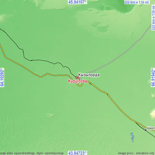
These maps also provides idea of topography and contour of this city, they are displayed at different zoom levels. More info about maps, scale and edge coordinates you can find below images.
| \ | Map #1 | Map #2 | Topo.Map |
| Scale [m] | 119..134 m | 118..140 m | × |
| Scale [ft] | 390..440 ft | 387..459 ft | × |
| Average | 126 m = 413 ft | 124.9 m = 410 ft | × |
| Width | 6.93 km = 4.3 mi | 13.86 km = 8.6 mi | 221.7 km = 137.8 mi |
| Height | 6.93 km = 4.3 mi | 13.86 km = 8.6 mi | 221.7 km = 137.8 mi |
| ↑Max Latitude | 44.883925° | 44.915054° | 45.84107° |
| Latitude at center | 44.85278° | 44.85278° | 44.85278° |
| ↓Min Latitude | 44.821618° | 44.790439° | 43.84723° |
| ← Min Longitude | 65.465225° | 65.421279° | 64.10292° |
| Longitude center | 65.50917° | 65.50917° | 65.50917° |
| →Max Longitude | 65.553115° | 65.597061° | 66.91542° |
Nearby cities:
Cities around Kyzylorda sort by population:
• Turkestan elevation 214 m
279.1 km,  128°
128°
• Baikonur 91 m
191.5 km,  296°
296°
• Kentau 426 m
281.2 km,  121°
121°
• Shīeli 154 m
123.7 km, 127°
• Yanykurgan 166 m
173.6 km, 127°
• Zhosaly 100 m
132.5 km, 302°
• Tasböget 129 m
9.4 km,  158°
158°
• Dzhalagash 111 m
71.1 km,  291°
291°
• Terenozek 119 m
46.8 km, 298°
• Tyuratam 106 m
193.5 km, 297°
• Shalqīya 235 m
177.7 km, 121°
• Belköl 128 m
7.7 km, 126°
Multilingual:
 En español:
Kyzylorda elevación 128 m.
 En France:
Kyzylorda élévation 128 m.
 Auf Deutsch:
Qysylorda höhe über dem Meeresspiegel ist 128 m.
 На русском:
Кызылорда, Кзыл-Орда, Ак-Мечеть, Перовск, Форт Перовский высота над уровнем моря 128 м
Sources and notes:
- [note 1] Map square and city borders are not equal. Map elevation data is calculated only from area inside that square.
- [src 1] Elevation data from geonames database provided with same terms of usage.
- [src 2] The elevation map of Kyzylorda is generated using elevation data from NASA's 3 arcsec (90m) resolution SRTM data.
- [src 3] Base (background) map © OpenStreetMap contributors tiles are generated by Geofabrik and OpenTopoMap.
Copyright & License:
This Kyzylorda Elevation Map is licensed under CC BY-SA. You may reuse any part from this page, if you give a proper credit by linking to this URL:
 More info on terms of use page.