Nodong elevation
Nodong (Jeollanam-do), South Korea elevation is 145 meters and Nodong elevation in feet is 476 ft above sea level [src 1]. Nodong is a seat of a third-order administrative division (feature code) with elevation that is 73 meters (240 ft) bigger than average city elevation in South Korea.
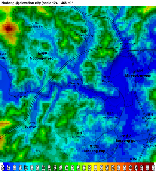
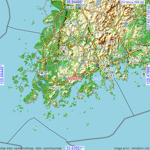
Below is the Elevation map of Nodong, which displays elevation range with different colors. Scale of the first map is from 124 to 468 m (407 to 1535 ft) with average elevation of 190.2 meters (=624 ft) [note 1]
These maps also provides idea of topography and contour of this city, they are displayed at different zoom levels. More info about maps, scale and edge coordinates you can find below images.
| \ | Map #1 | Topo.Map |
| Scale [m] | 124..468 m | × |
| Scale [ft] | 407..1535 ft | × |
| Average | 190.2 m = 624 ft | × |
| Width | 8.02 km = 5 mi | 256.8 km = 159.6 mi |
| Height | 8.02 km = 5 mi | 256.8 km = 159.6 mi |
| ↑Max Latitude | 34.834099° | 35.94466° |
| Latitude at center | 34.79802° | 34.79802° |
| ↓Min Latitude | 34.761926° | 33.63521° |
| ← Min Longitude | 127.026785° | 125.66448° |
| Longitude center | 127.07073° | 127.07073° |
| →Max Longitude | 127.114675° | 128.47698° |
Nearby cities:
Cities around Nodong sort by population:
• Yuchi elevation 91 m
21.2 km,  271°
271°
• Hancheolli 85 m
20.6 km,  341°
341°
• Jangheung 28 m
19.8 km,  229°
229°
• Mundeok 131 m
17.3 km,  32°
32°
• Joseong 16 m
16.2 km,  85°
85°
• Yureo 135 m
13.4 km,  52°
52°
• Iyang 62 m
12.7 km,  323°
323°
• Cheongpung 77 m
12.7 km,  313°
313°
• Bongnae 112 m
11.9 km, 27°
• Gyeombaek 119 m
8.2 km,  64°
64°
• Boseong 162 m
3.1 km,  164°
164°
• Miryeok 132 m
1.6 km,  76°
76°
Multilingual:
 En español:
Nodong elevación 145 m.
 En France:
Nodong élévation 145 m.


Sources and notes:
- [note 1] Map square and city borders are not equal. Map elevation data is calculated only from area inside that square.
- [src 1] Elevation data from geonames database provided with same terms of usage.
- [src 2] The elevation map of Nodong is generated using elevation data from NASA's 3 arcsec (90m) resolution SRTM data.
- [src 3] Base (background) map © OpenStreetMap contributors tiles are generated by Geofabrik and OpenTopoMap.
Copyright & License:
This Nodong Elevation Map is licensed under CC BY-SA. You may reuse any part from this page, if you give a proper credit by linking to this URL:
 More info on terms of use page.