Jangheung elevation
Jangheung (Jeollanam-do), South Korea elevation is 28 meters and Jangheung elevation in feet is 92 ft above sea level [src 1]. Jangheung is a seat of a second-order administrative division (feature code) with elevation that is 44 meters (144 ft) smaller than average city elevation in South Korea.
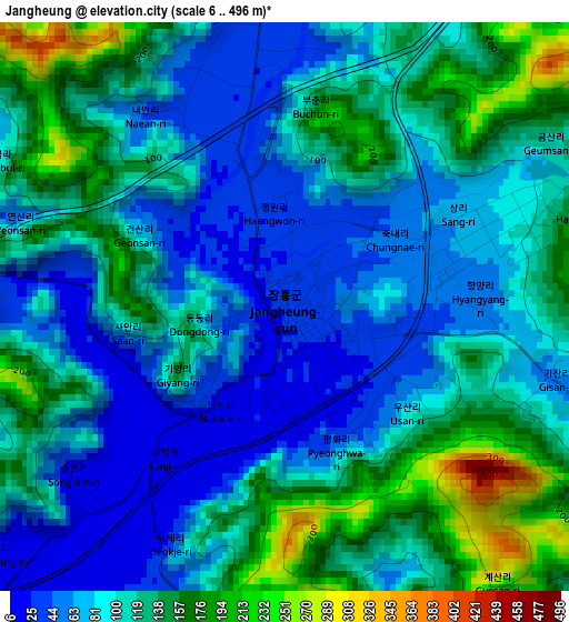
Below is the Elevation map of Jangheung, which displays elevation range with different colors. Scale of the first map is from 6 to 496 m (20 to 1627 ft) with average elevation of 105 meters (=344 ft) [note 1]
These maps also provides idea of topography and contour of this city, they are displayed at different zoom levels. More info about maps, scale and edge coordinates you can find below images.
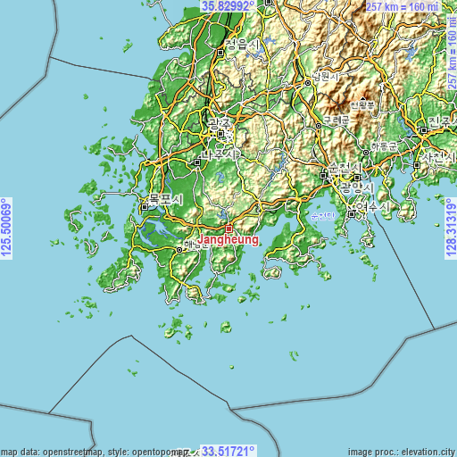
| \ | Map #1 | Topo.Map |
| Scale [m] | 6..496 m | × |
| Scale [ft] | 20..1627 ft | × |
| Average | 105 m = 344 ft | × |
| Width | 8.04 km = 5 mi | 257.1 km = 159.8 mi |
| Height | 8.04 km = 5 mi | 257.2 km = 159.8 mi |
| ↑Max Latitude | 34.71777° | 35.82992° |
| Latitude at center | 34.68164° | 34.68164° |
| ↓Min Latitude | 34.645495° | 33.51721° |
| ← Min Longitude | 126.862995° | 125.50069° |
| Longitude center | 126.90694° | 126.90694° |
| →Max Longitude | 126.950885° | 128.31319° |
Nearby cities:
Cities around Jangheung sort by population:
• Yeongam elevation 34 m
23.3 km,  304°
304°
• Seji 35 m
30.2 km,  331°
331°
• Dopo 17 m
30.2 km,  307°
307°
• Gyeombaek 119 m
27.8 km,  53°
53°
• Geumjeong 50 m
24.8 km,  324°
324°
• Deokjin 10 m
24.6 km, 308°
• Iyang 62 m
24.3 km,  17°
17°
• Cheongpung 77 m
22.5 km,  14°
14°
• Miryeok 132 m
21.2 km, 51°
• Nodong 145 m
19.8 km, 49°
• Boseong 162 m
18.7 km,  57°
57°
• Yuchi 91 m
14.8 km,  335°
335°
Multilingual:
 En español:
Jangheung elevación 28 m.
 En France:
Jangheung élévation 28 m.
 Auf Deutsch:
Jangheung höhe über dem Meeresspiegel ist 28 m.

Sources and notes:
- [note 1] Map square and city borders are not equal. Map elevation data is calculated only from area inside that square.
- [src 1] Elevation data from geonames database provided with same terms of usage.
- [src 2] The elevation map of Jangheung is generated using elevation data from NASA's 3 arcsec (90m) resolution SRTM data.
- [src 3] Base (background) map © OpenStreetMap contributors tiles are generated by Geofabrik and OpenTopoMap.
Copyright & License:
This Jangheung Elevation Map is licensed under CC BY-SA. You may reuse any part from this page, if you give a proper credit by linking to this URL:
 More info on terms of use page.