Changnyeong elevation
Changnyeong (Gyeongsangnam-do), South Korea elevation is 66 meters and Changnyeong elevation in feet is 217 ft above sea level [src 1]. Changnyeong is a populated place (feature code) with elevation that is 6 meters (20 ft) smaller than average city elevation in South Korea.
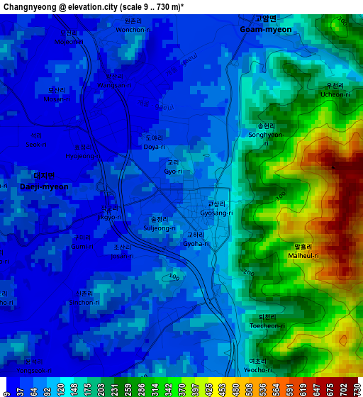
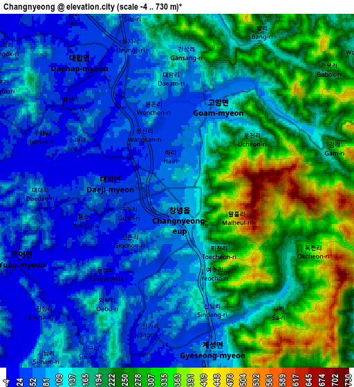
Below is the Elevation map of Changnyeong, which displays elevation range with different colors. Scale of the first map is from 9 to 730 m (30 to 2395 ft) with average elevation of 143.2 meters (=470 ft) [note 1]
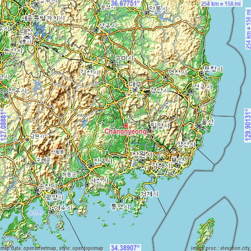
These maps also provides idea of topography and contour of this city, they are displayed at different zoom levels. More info about maps, scale and edge coordinates you can find below images.
| \ | Map #1 | Map #2 | Topo.Map |
| Scale [m] | 9..730 m | -4..730 m | × |
| Scale [ft] | 30..2395 ft | -13..2395 ft | × |
| Average | 143.2 m = 470 ft | 159.4 m = 523 ft | × |
| Width | 7.95 km = 4.9 mi | 15.9 km = 9.9 mi | 254.5 km = 158.1 mi |
| Height | 7.95 km = 4.9 mi | 15.9 km = 9.9 mi | 254.5 km = 158.1 mi |
| ↑Max Latitude | 35.5772° | 35.612934° | 36.67751° |
| Latitude at center | 35.54145° | 35.54145° | 35.54145° |
| ↓Min Latitude | 35.505684° | 35.469902° | 34.38907° |
| ← Min Longitude | 128.451115° | 128.407169° | 127.08881° |
| Longitude center | 128.49506° | 128.49506° | 128.49506° |
| →Max Longitude | 128.539005° | 128.582951° | 129.90131° |
Nearby cities:
Cities around Changnyeong sort by population:
• Daegu elevation 45 m
37.6 km,  13°
13°
• Changwon 27 m
38.7 km,  154°
154°
• Kimhae 13 m
48.9 km,  134°
134°
• Gyeongsan-si 59 m
38.2 km,  34°
34°
• Naesŏ 62 m
32.5 km,  176°
176°
• Yangsan 6 m
53.6 km,  114°
114°
• Hwawŏn 36 m
28.9 km,  1°
1°
• Miryang 14 m
23.6 km,  103°
103°
• Hayang 57 m
50.7 km,  35°
35°
• Waegwan 33 m
50.9 km,  350°
350°
• Hyeonpung 29 m
17.7 km, 345°
• Daehap 43 m
8.3 km, 345°
Multilingual:
 En español:
Changnyeong elevación 66 m.
 En France:
Changnyeong élévation 66 m.
 Auf Deutsch:
Changnyeong höhe über dem Meeresspiegel ist 66 m.

Sources and notes:
- [note 1] Map square and city borders are not equal. Map elevation data is calculated only from area inside that square.
- [src 1] Elevation data from geonames database provided with same terms of usage.
- [src 2] The elevation map of Changnyeong is generated using elevation data from NASA's 3 arcsec (90m) resolution SRTM data.
- [src 3] Base (background) map © OpenStreetMap contributors tiles are generated by Geofabrik and OpenTopoMap.
Copyright & License:
This Changnyeong Elevation Map is licensed under CC BY-SA. You may reuse any part from this page, if you give a proper credit by linking to this URL:
 More info on terms of use page.