Waegwan elevation
Waegwan (Gyeongsangbuk-do), South Korea elevation is 33 meters and Waegwan elevation in feet is 108 ft above sea level [src 1]. Waegwan is a seat of a third-order administrative division (feature code) with elevation that is 39 meters (128 ft) smaller than average city elevation in South Korea.
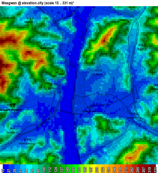
Below is the Elevation map of Waegwan, which displays elevation range with different colors. Scale of the first map is from 15 to 331 m (49 to 1086 ft) with average elevation of 80.2 meters (=263 ft) [note 1]
These maps also provides idea of topography and contour of this city, they are displayed at different zoom levels. More info about maps, scale and edge coordinates you can find below images.
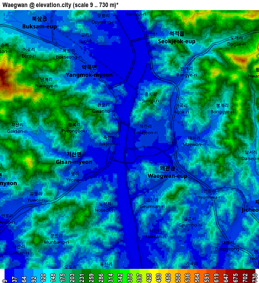
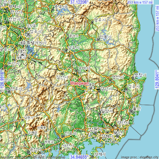
| \ | Map #1 | Map #2 | Topo.Map |
| Scale [m] | 15..331 m | 9..730 m | × |
| Scale [ft] | 49..1086 ft | 30..2395 ft | × |
| Average | 80.2 m = 263 ft | 130.4 m = 428 ft | × |
| Width | 7.91 km = 4.9 mi | 15.81 km = 9.8 mi | 253 km = 157.2 mi |
| Height | 7.91 km = 4.9 mi | 15.81 km = 9.8 mi | 253 km = 157.2 mi |
| ↑Max Latitude | 36.028058° | 36.06359° | 37.12206° |
| Latitude at center | 35.99251° | 35.99251° | 35.99251° |
| ↓Min Latitude | 35.956946° | 35.921366° | 34.84655° |
| ← Min Longitude | 128.353905° | 128.309959° | 126.9916° |
| Longitude center | 128.39785° | 128.39785° | 128.39785° |
| →Max Longitude | 128.441795° | 128.485741° | 129.8041° |
Nearby cities:
Cities around Waegwan sort by population:
• Daegu elevation 45 m
22.1 km,  127°
127°
• Gumi 63 m
14.6 km,  337°
337°
• Gimcheon 81 m
28.8 km,  299°
299°
• Gyeongsan-si 59 m
35.9 km,  121°
121°
• Hwawŏn 36 m
23.2 km,  156°
156°
• Eisen 85 m
48 km,  93°
93°
• Hayang 57 m
39 km,  103°
103°
• Kunwi 95 m
31.2 km,  30°
30°
• Jenzan 48 m
29 km, 341°
• Chupungnyeong 219 m
44.2 km, 304°
• Daehap 43 m
42.6 km,  171°
171°
• Hyeonpung 29 m
33.3 km, 172°
Multilingual:
 En español:
Waegwan elevación 33 m.
 En France:
Waegwan élévation 33 m.


Sources and notes:
- [note 1] Map square and city borders are not equal. Map elevation data is calculated only from area inside that square.
- [src 1] Elevation data from geonames database provided with same terms of usage.
- [src 2] The elevation map of Waegwan is generated using elevation data from NASA's 3 arcsec (90m) resolution SRTM data.
- [src 3] Base (background) map © OpenStreetMap contributors tiles are generated by Geofabrik and OpenTopoMap.
Copyright & License:
This Waegwan Elevation Map is licensed under CC BY-SA. You may reuse any part from this page, if you give a proper credit by linking to this URL:
 More info on terms of use page.