Icheon-si elevation
Icheon-si (Gyeonggi-do), South Korea elevation is 68 meters and Icheon-si elevation in feet is 223 ft above sea level [src 1]. Icheon-si is a populated place (feature code) with elevation that is 4 meters (13 ft) smaller than average city elevation in South Korea.
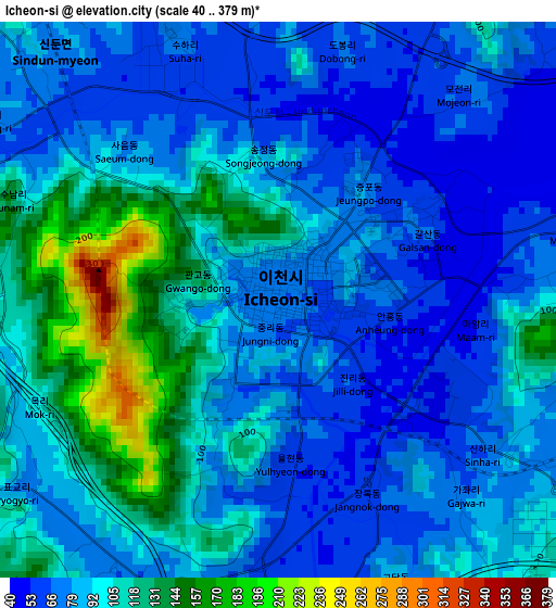
Below is the Elevation map of Icheon-si, which displays elevation range with different colors. Scale of the first map is from 40 to 379 m (131 to 1243 ft) with average elevation of 91.8 meters (=301 ft) [note 1]
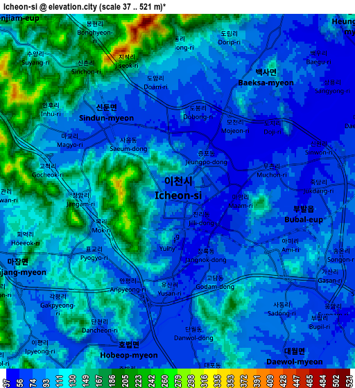
These maps also provides idea of topography and contour of this city, they are displayed at different zoom levels. More info about maps, scale and edge coordinates you can find below images.
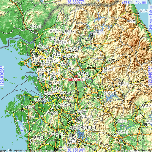
| \ | Map #1 | Map #2 | Topo.Map |
| Scale [m] | 40..379 m | 37..521 m | × |
| Scale [ft] | 131..1243 ft | 121..1709 ft | × |
| Average | 91.8 m = 301 ft | 105 m = 344 ft | × |
| Width | 7.78 km = 4.8 mi | 15.55 km = 9.7 mi | 248.8 km = 154.6 mi |
| Height | 7.78 km = 4.8 mi | 15.55 km = 9.7 mi | 248.8 km = 154.6 mi |
| ↑Max Latitude | 37.314129° | 37.349072° | 38.38977° |
| Latitude at center | 37.27917° | 37.27917° | 37.27917° |
| ↓Min Latitude | 37.244195° | 37.209203° | 36.15194° |
| ← Min Longitude | 127.398555° | 127.354609° | 126.03625° |
| Longitude center | 127.4425° | 127.4425° | 127.4425° |
| →Max Longitude | 127.486445° | 127.530391° | 128.84875° |
Nearby cities:
Cities around Icheon-si sort by population:
• Suwon elevation 58 m
38.4 km,  271°
271°
• Seongnam-si 80 m
32.2 km,  303°
303°
• Guri-si 31 m
44.5 km,  323°
323°
• Osan 22 m
35.8 km,  246°
246°
• Hanam 33 m
35.8 km, 324°
• Hwado 86 m
43.2 km,  343°
343°
• Wabu 38 m
39.7 km,  330°
330°
• Yangp'yŏng 38 m
23.8 km,  10°
10°
• Gwangju 48 m
21.9 km,  311°
311°
• Anseong 37 m
33.5 km,  207°
207°
• Pubal 55 m
5.9 km,  76°
76°
• Yeoju 50 m
17 km, 83°
Multilingual:
 En español:
Icheon-si elevación 68 m.
 En France:
Icheon-si élévation 68 m.
 Auf Deutsch:
Icheon-si höhe über dem Meeresspiegel ist 68 m.

Sources and notes:
- [note 1] Map square and city borders are not equal. Map elevation data is calculated only from area inside that square.
- [src 1] Elevation data from geonames database provided with same terms of usage.
- [src 2] The elevation map of Icheon-si is generated using elevation data from NASA's 3 arcsec (90m) resolution SRTM data.
- [src 3] Base (background) map © OpenStreetMap contributors tiles are generated by Geofabrik and OpenTopoMap.
Copyright & License:
This Icheon-si Elevation Map is licensed under CC BY-SA. You may reuse any part from this page, if you give a proper credit by linking to this URL:
 More info on terms of use page.