Mitsoudjé elevation
Mitsoudjé (Grande Comore), Comoros elevation is 154 meters and Mitsoudjé elevation in feet is 505 ft above sea level [src 1]. Mitsoudjé is a populated place (feature code) with elevation that is 40 meters (131 ft) smaller than average city elevation in Comoros.
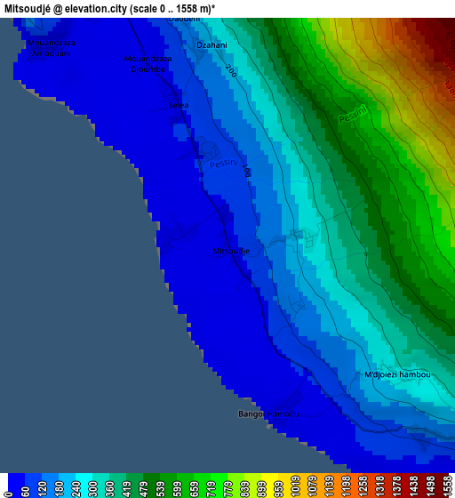
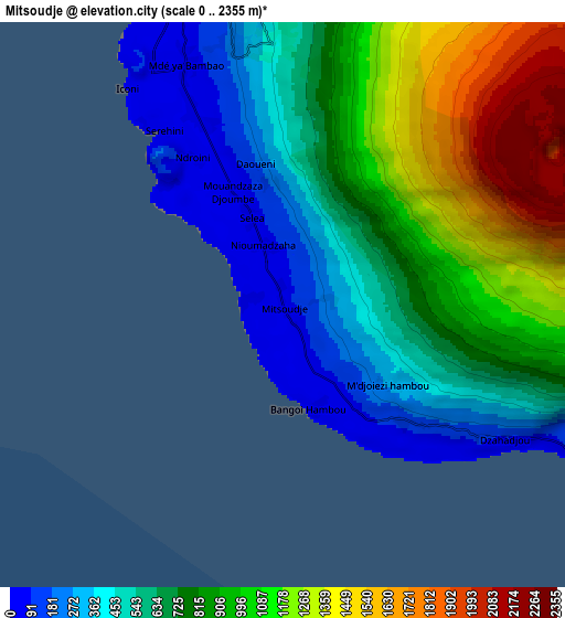
Below is the Elevation map of Mitsoudjé, which displays elevation range with different colors. Scale of the first map is from 0 to 1558 m (0 to 5112 ft) with average elevation of 314.4 meters (=1031 ft) [note 1]
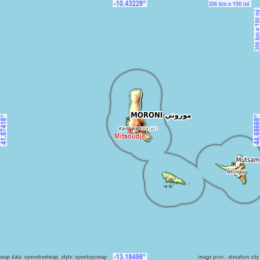
These maps also provides idea of topography and contour of this city, they are displayed at different zoom levels. More info about maps, scale and edge coordinates you can find below images.
| \ | Map #1 | Map #2 | Topo.Map |
| Scale [m] | 0..1558 m | 0..2355 m | × |
| Scale [ft] | 0..5112 ft | 0..7726 ft | × |
| Average | 314.4 m = 1031 ft | 793.1 m = 2602 ft | × |
| Width | 9.57 km = 5.9 mi | 19.13 km = 11.9 mi | 306.1 km = 190.2 mi |
| Height | 9.57 km = 5.9 mi | 19.13 km = 11.9 mi | 306.1 km = 190.2 mi |
| ↑Max Latitude | -11.769072° | -11.726047° | -10.43229° |
| Latitude at center | -11.81209° | -11.81209° | -11.81209° |
| ↓Min Latitude | -11.855101° | -11.898106° | -13.18498° |
| ← Min Longitude | 43.236485° | 43.192539° | 41.87418° |
| Longitude center | 43.28043° | 43.28043° | 43.28043° |
| →Max Longitude | 43.324375° | 43.368321° | 44.68668° |
Nearby cities:
Cities around Mitsoudjé sort by population:
• Moroni elevation 27 m
12.5 km,  347°
347°
• Mvouni 218 m
10.8 km, 350°
• Tsidjé 83 m
12.8 km, 350°
• Dembéni 280 m
14.5 km,  118°
118°
• Itsandra 26 m
15.9 km, 349°
• Chouani 294 m
2 km,  129°
129°
• Singani 147 m
5.6 km, 134°
• Dzahadjou 12 m
8.8 km, 120°
• Séléa 24 m
3.7 km,  325°
325°
• Salimani 78 m
1.3 km,  272°
272°
• Mavingouni 43 m
11.1 km,  344°
344°
• Madjeouéni 35 m
1.1 km,  193°
193°
Multilingual:
 En español:
Mitsoudjé elevación 154 m.
 En France:
Mitsoudjé élévation 154 m.
 Auf Deutsch:
Mitsoudjé höhe über dem Meeresspiegel ist 154 m.

Sources and notes:
- [note 1] Map square and city borders are not equal. Map elevation data is calculated only from area inside that square.
- [src 1] Elevation data from geonames database provided with same terms of usage.
- [src 2] The elevation map of Mitsoudjé is generated using elevation data from NASA's 3 arcsec (90m) resolution SRTM data.
- [src 3] Base (background) map © OpenStreetMap contributors tiles are generated by Geofabrik and OpenTopoMap.
Copyright & License:
This Mitsoudjé Elevation Map is licensed under CC BY-SA. You may reuse any part from this page, if you give a proper credit by linking to this URL:
 More info on terms of use page.