Pailin elevation
Pailin, Cambodia elevation is 201 meters and Pailin elevation in feet is 659 ft above sea level [src 1]. Pailin is a seat of a first-order administrative division (feature code) with elevation that is 149 meters (489 ft) bigger than average city elevation in Cambodia.
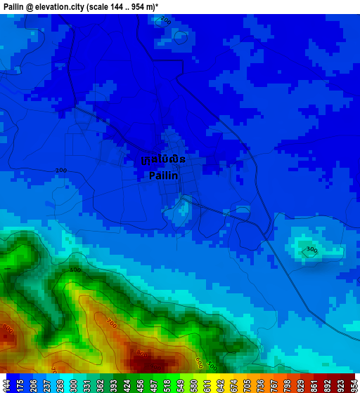
Below is the Elevation map of Pailin, which displays elevation range with different colors. Scale of the first map is from 144 to 954 m (472 to 3130 ft) with average elevation of 259.4 meters (=851 ft) [note 1]
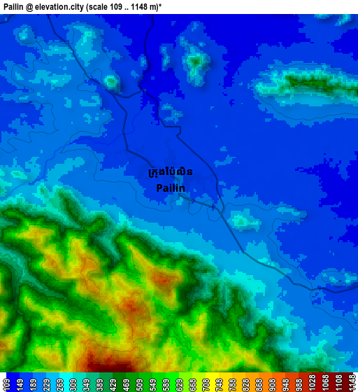
These maps also provides idea of topography and contour of this city, they are displayed at different zoom levels. More info about maps, scale and edge coordinates you can find below images.
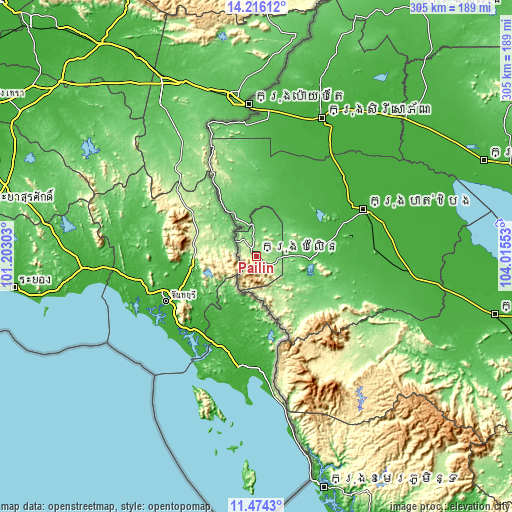
| \ | Map #1 | Map #2 | Topo.Map |
| Scale [m] | 144..954 m | 109..1148 m | × |
| Scale [ft] | 472..3130 ft | 358..3766 ft | × |
| Average | 259.4 m = 851 ft | 311.1 m = 1021 ft | × |
| Width | 9.53 km = 5.9 mi | 19.06 km = 11.8 mi | 304.9 km = 189.5 mi |
| Height | 9.53 km = 5.9 mi | 19.06 km = 11.8 mi | 304.9 km = 189.5 mi |
| ↑Max Latitude | 12.891791° | 12.934625° | 14.21612° |
| Latitude at center | 12.84895° | 12.84895° | 12.84895° |
| ↓Min Latitude | 12.806101° | 12.763246° | 11.4743° |
| ← Min Longitude | 102.565335° | 102.521389° | 101.20303° |
| Longitude center | 102.60928° | 102.60928° | 102.60928° |
| →Max Longitude | 102.653225° | 102.697171° | 104.01553° |
Nearby cities:
Cities around Pailin sort by population:
• Battambang elevation 18 m
69.8 km,  66°
66°
• Aek Phnum 16 m
75.7 km,  62°
62°
• Sangkae 17 m
73.4 km, 69°
• Koas Krala 27 m
70.8 km,  98°
98°
• Sampov Lun 176 m
69.6 km,  338°
338°
• Bat Dambang 15 m
69.5 km,  48°
48°
• Banan 28 m
58.7 km,  80°
80°
• Bavel 24 m
53.4 km,  33°
33°
• Phnum Proek 127 m
47.7 km,  330°
330°
• Samlout 118 m
37.4 km,  133°
133°
• Kamrieng 84 m
29.5 km, 334°
• Sala Krau 105 m
11.9 km,  359°
359°
Multilingual:
 En español:
Ciudad de Pailín elevación 201 m.
 En France:
Pailin élévation 201 m.


Sources and notes:
- [note 1] Map square and city borders are not equal. Map elevation data is calculated only from area inside that square.
- [src 1] Elevation data from geonames database provided with same terms of usage.
- [src 2] The elevation map of Pailin is generated using elevation data from NASA's 3 arcsec (90m) resolution SRTM data.
- [src 3] Base (background) map © OpenStreetMap contributors tiles are generated by Geofabrik and OpenTopoMap.
Copyright & License:
This Pailin Elevation Map is licensed under CC BY-SA. You may reuse any part from this page, if you give a proper credit by linking to this URL:
 More info on terms of use page.