Battambang elevation
Battambang, Cambodia elevation is 18 meters and Battambang elevation in feet is 59 ft above sea level [src 1]. Battambang is a seat of a first-order administrative division (feature code) with elevation that is 34 meters (112 ft) smaller than average city elevation in Cambodia.
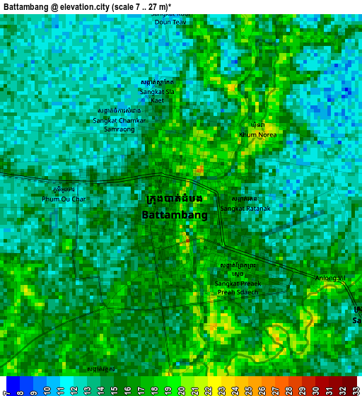
Below is the Elevation map of Battambang, which displays elevation range with different colors. Scale of the first map is from 7 to 27 m (23 to 89 ft) with average elevation of 14.4 meters (=47 ft) [note 1]
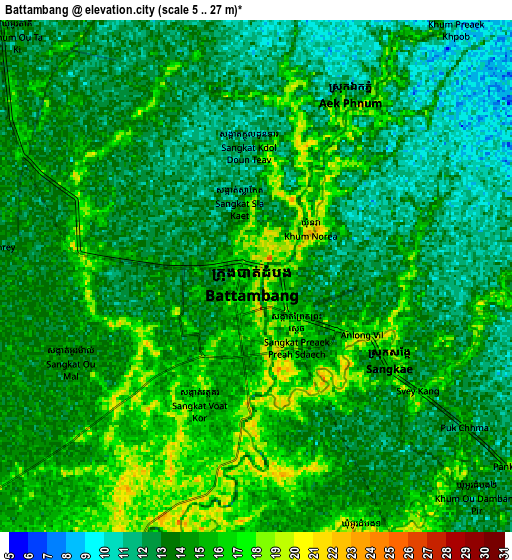
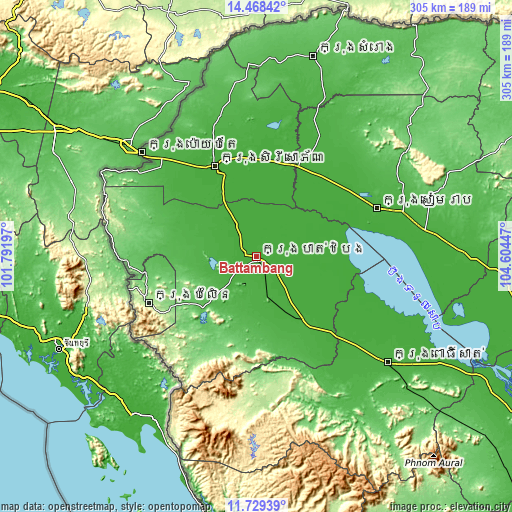
These maps also provides idea of topography and contour of this city, they are displayed at different zoom levels. More info about maps, scale and edge coordinates you can find below images.
| \ | Map #1 | Map #2 | Topo.Map |
| Scale [m] | 7..27 m | 5..27 m | × |
| Scale [ft] | 23..89 ft | 16..89 ft | × |
| Average | 14.4 m = 47 ft | 13.6 m = 45 ft | × |
| Width | 9.52 km = 5.9 mi | 19.04 km = 11.8 mi | 304.6 km = 189.3 mi |
| Height | 9.52 km = 5.9 mi | 19.04 km = 11.8 mi | 304.6 km = 189.3 mi |
| ↑Max Latitude | 13.145507° | 13.188297° | 14.46842° |
| Latitude at center | 13.10271° | 13.10271° | 13.10271° |
| ↓Min Latitude | 13.059905° | 13.017093° | 11.72939° |
| ← Min Longitude | 103.154275° | 103.110329° | 101.79197° |
| Longitude center | 103.19822° | 103.19822° | 103.19822° |
| →Max Longitude | 103.242165° | 103.286111° | 104.60447° |
Nearby cities:
Cities around Battambang sort by population:
• Sisophon elevation 19 m
59 km,  335°
335°
• Kralanh 21 m
60.8 km,  23°
23°
• Preah Netr Preah 16 m
58 km,  358°
358°
• Mongkol Borei 16 m
52.1 km, 339°
• Moung Ruessei 20 m
45.5 km,  143°
143°
• Ta Loas 20 m
43.4 km, 139°
• Koas Krala 27 m
39.1 km,  170°
170°
• Bavel 24 m
38.4 km,  295°
295°
• Bat Dambang 15 m
21.3 km,  326°
326°
• Banan 28 m
19.1 km,  198°
198°
• Aek Phnum 16 m
7.3 km,  29°
29°
• Sangkae 17 m
5.6 km,  117°
117°
Multilingual:
 En español:
Ciudad de Battambang elevación 18 m.
 En France:
Battambang élévation 18 m.
 Auf Deutsch:
Battambang höhe über dem Meeresspiegel ist 18 m.

Sources and notes:
- [note 1] Map square and city borders are not equal. Map elevation data is calculated only from area inside that square.
- [src 1] Elevation data from geonames database provided with same terms of usage.
- [src 2] The elevation map of Battambang is generated using elevation data from NASA's 3 arcsec (90m) resolution SRTM data.
- [src 3] Base (background) map © OpenStreetMap contributors tiles are generated by Geofabrik and OpenTopoMap.
Copyright & License:
This Battambang Elevation Map is licensed under CC BY-SA. You may reuse any part from this page, if you give a proper credit by linking to this URL:
 More info on terms of use page.