Stung Treng elevation
Stung Treng, Cambodia elevation is 55 meters and Stung Treng elevation in feet is 180 ft above sea level [src 1]. Stung Treng is a seat of a first-order administrative division (feature code) with elevation that is 3 meters (10 ft) bigger than average city elevation in Cambodia.
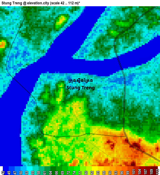
Below is the Elevation map of Stung Treng, which displays elevation range with different colors. Scale of the first map is from 42 to 112 m (138 to 367 ft) with average elevation of 60.6 meters (=199 ft) [note 1]
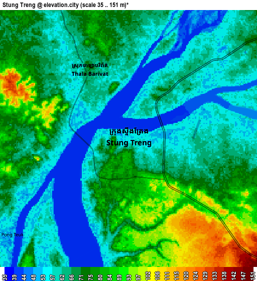
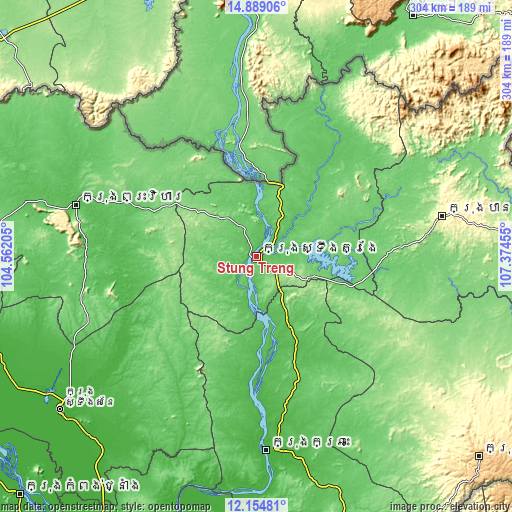
These maps also provides idea of topography and contour of this city, they are displayed at different zoom levels. More info about maps, scale and edge coordinates you can find below images.
| \ | Map #1 | Map #2 | Topo.Map |
| Scale [m] | 42..112 m | 35..151 m | × |
| Scale [ft] | 138..367 ft | 115..495 ft | × |
| Average | 60.6 m = 199 ft | 68 m = 223 ft | × |
| Width | 9.5 km = 5.9 mi | 19 km = 11.8 mi | 304 km = 188.9 mi |
| Height | 9.5 km = 5.9 mi | 19 km = 11.8 mi | 304 km = 188.9 mi |
| ↑Max Latitude | 13.568583° | 13.611298° | 14.88906° |
| Latitude at center | 13.52586° | 13.52586° | 13.52586° |
| ↓Min Latitude | 13.48313° | 13.440392° | 12.15481° |
| ← Min Longitude | 105.924355° | 105.880409° | 104.56205° |
| Longitude center | 105.9683° | 105.9683° | 105.9683° |
| →Max Longitude | 106.012245° | 106.056191° | 107.37455° |
Nearby cities:
Cities around Stung Treng sort by population:
• Tbeng Meanchey elevation 59 m
111.2 km,  286°
286°
• Kratié 27 m
115.5 km,  177°
177°
• Lumphat 101 m
109.5 km,  92°
92°
• Banlung 316 m
112.6 km,  77°
77°
• Ou Chum 253 m
114.8 km,  74°
74°
• Sangkom Thmei 97 m
114.2 km,  273°
273°
• Pal Hal 63 m
111 km, 285°
• Veun Sai 93 m
103.9 km,  61°
61°
• Sandan 24 m
90.4 km,  238°
238°
• Koun Mom 117 m
87.2 km, 86°
• Siem Pang 71 m
79.9 km,  34°
34°
• Sesan 60 m
13.7 km, 77°
Multilingual:
 En español:
Stung Treng elevación 55 m.
 En France:
Stung-treng élévation 55 m.
 Auf Deutsch:
Stung Treng höhe über dem Meeresspiegel ist 55 m.

Sources and notes:
- [note 1] Map square and city borders are not equal. Map elevation data is calculated only from area inside that square.
- [src 1] Elevation data from geonames database provided with same terms of usage.
- [src 2] The elevation map of Stung Treng is generated using elevation data from NASA's 3 arcsec (90m) resolution SRTM data.
- [src 3] Base (background) map © OpenStreetMap contributors tiles are generated by Geofabrik and OpenTopoMap.
Copyright & License:
This Stung Treng Elevation Map is licensed under CC BY-SA. You may reuse any part from this page, if you give a proper credit by linking to this URL:
 More info on terms of use page.