Garissa elevation
Garissa, Kenya elevation is 147 meters and Garissa elevation in feet is 482 ft above sea level [src 1]. Garissa is a seat of a first-order administrative division (feature code) with elevation that is 1199 meters (3934 ft) smaller than average city elevation in Kenya.
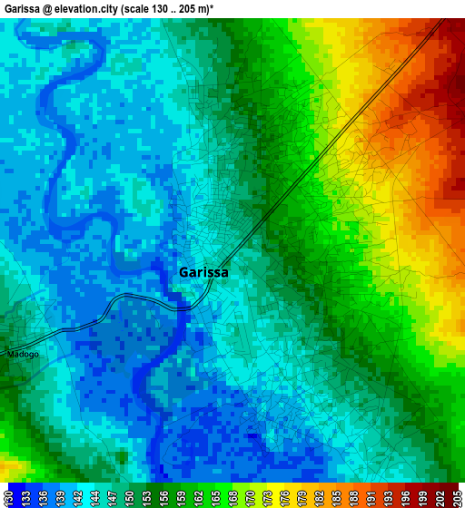
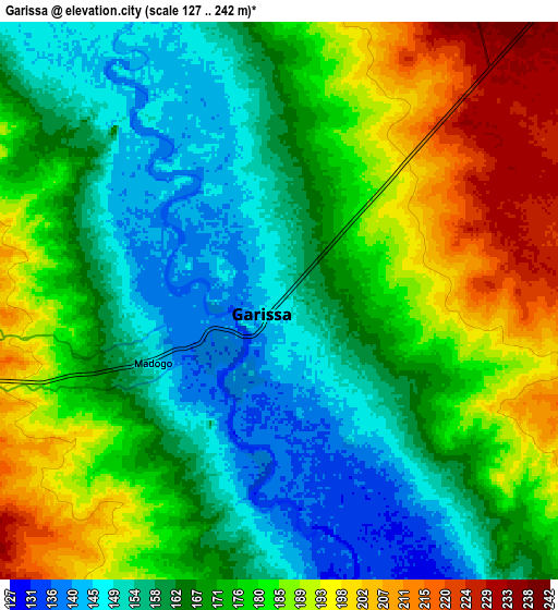
Below is the Elevation map of Garissa, which displays elevation range with different colors. Scale of the first map is from 130 to 205 m (427 to 673 ft) with average elevation of 152.8 meters (=501 ft) [note 1]
These maps also provides idea of topography and contour of this city, they are displayed at different zoom levels. More info about maps, scale and edge coordinates you can find below images.
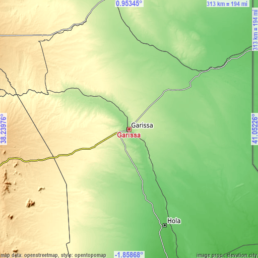
| \ | Map #1 | Map #2 | Topo.Map |
| Scale [m] | 130..205 m | 127..242 m | × |
| Scale [ft] | 427..673 ft | 417..794 ft | × |
| Average | 152.8 m = 501 ft | 172.2 m = 565 ft | × |
| Width | 9.77 km = 6.1 mi | 19.54 km = 12.1 mi | 312.7 km = 194.3 mi |
| Height | 9.77 km = 6.1 mi | 19.54 km = 12.1 mi | 312.7 km = 194.3 mi |
| ↑Max Latitude | -0.408806° | -0.364862° | 0.95345° |
| Latitude at center | -0.45275° | -0.45275° | -0.45275° |
| ↓Min Latitude | -0.496694° | -0.540637° | -1.85868° |
| ← Min Longitude | 39.602065° | 39.558119° | 38.23976° |
| Longitude center | 39.64601° | 39.64601° | 39.64601° |
| →Max Longitude | 39.689955° | 39.733901° | 41.05226° |
Nearby cities:
Cities around Garissa sort by population:
• Meru elevation 1579 m
228.1 km,  284°
284°
• Wajir 258 m
248.8 km,  10°
10°
• Embu 1294 m
243.5 km,  267°
267°
• Isiolo 1095 m
246.4 km,  291°
291°
• Lamu 14 m
245.8 km,  145°
145°
• Kitui 1154 m
208.3 km,  240°
240°
• Mwingi 947 m
184.4 km,  253°
253°
• Maua 1655 m
204.4 km, 291°
• Chuka 1452 m
222.8 km, 273°
• Hola 65 m
122.3 km,  159°
159°
• Witu 16 m
232.6 km, 157°
• Kathwana 722 m
198.1 km, 273°
Multilingual:
 En español:
Garissa elevación 147 m.
 En France:
Garissa élévation 147 m.


Sources and notes:
- [note 1] Map square and city borders are not equal. Map elevation data is calculated only from area inside that square.
- [src 1] Elevation data from geonames database provided with same terms of usage.
- [src 2] The elevation map of Garissa is generated using elevation data from NASA's 3 arcsec (90m) resolution SRTM data.
- [src 3] Base (background) map © OpenStreetMap contributors tiles are generated by Geofabrik and OpenTopoMap.
Copyright & License:
This Garissa Elevation Map is licensed under CC BY-SA. You may reuse any part from this page, if you give a proper credit by linking to this URL:
 More info on terms of use page.