Kitui elevation
Kitui, Kenya elevation is 1154 meters and Kitui elevation in feet is 3786 ft above sea level [src 1]. Kitui is a seat of a first-order administrative division (feature code) with elevation that is 192 meters (630 ft) smaller than average city elevation in Kenya.
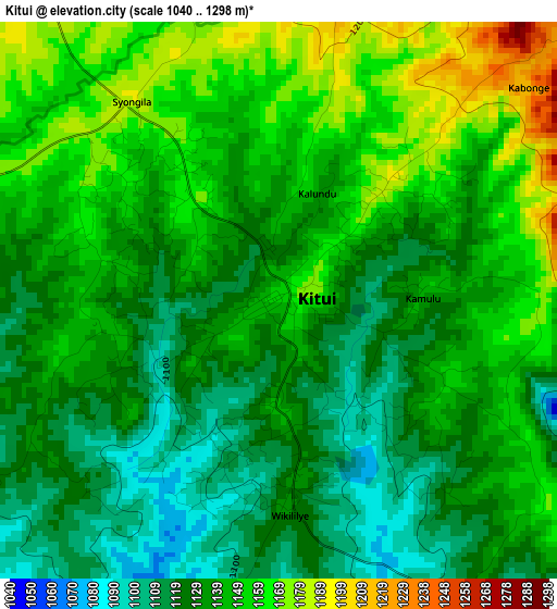
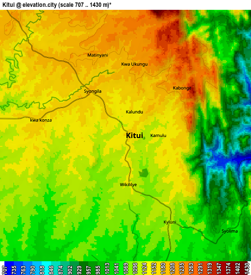
Below is the Elevation map of Kitui, which displays elevation range with different colors. Scale of the first map is from 1040 to 1298 m (3412 to 4259 ft) with average elevation of 1139.7 meters (=3739 ft) [note 1]
These maps also provides idea of topography and contour of this city, they are displayed at different zoom levels. More info about maps, scale and edge coordinates you can find below images.
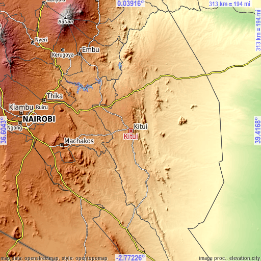
| \ | Map #1 | Map #2 | Topo.Map |
| Scale [m] | 1040..1298 m | 707..1430 m | × |
| Scale [ft] | 3412..4259 ft | 2320..4692 ft | × |
| Average | 1139.7 m = 3739 ft | 1105.6 m = 3627 ft | × |
| Width | 9.77 km = 6.1 mi | 19.54 km = 12.1 mi | 312.6 km = 194.2 mi |
| Height | 9.77 km = 6.1 mi | 19.54 km = 12.1 mi | 312.6 km = 194.2 mi |
| ↑Max Latitude | -1.323027° | -1.279093° | 0.03916° |
| Latitude at center | -1.36696° | -1.36696° | -1.36696° |
| ↓Min Latitude | -1.410892° | -1.454824° | -2.77226° |
| ← Min Longitude | 37.966605° | 37.922659° | 36.6043° |
| Longitude center | 38.01055° | 38.01055° | 38.01055° |
| →Max Longitude | 38.054495° | 38.098441° | 39.4168° |
Nearby cities:
Cities around Kitui sort by population:
• Thika elevation 1506 m
111 km,  289°
289°
• Embu 1294 m
110.6 km,  326°
326°
• Machakos 1619 m
84.6 km,  258°
258°
• Athi River 1505 m
115.2 km,  265°
265°
• Karuri 1211 m
118.1 km,  308°
308°
• Makueni Boma 1219 m
64.8 km,  221°
221°
• Mwingi 947 m
48.2 km,  6°
6°
• Kangundo 1546 m
74 km,  275°
275°
• Wote 1128 m
62.6 km, 222°
• Maragua 1360 m
116.4 km,  303°
303°
• Konza 1596 m
106.1 km,  247°
247°
• Kathwana 722 m
116.2 km,  352°
352°
Multilingual:
 En español:
Kitui elevación 1154 m.
 En France:
Kitui élévation 1154 m.


Sources and notes:
- [note 1] Map square and city borders are not equal. Map elevation data is calculated only from area inside that square.
- [src 1] Elevation data from geonames database provided with same terms of usage.
- [src 2] The elevation map of Kitui is generated using elevation data from NASA's 3 arcsec (90m) resolution SRTM data.
- [src 3] Base (background) map © OpenStreetMap contributors tiles are generated by Geofabrik and OpenTopoMap.
Copyright & License:
This Kitui Elevation Map is licensed under CC BY-SA. You may reuse any part from this page, if you give a proper credit by linking to this URL:
 More info on terms of use page.