Marsabit elevation
Marsabit, Kenya elevation is 1364 meters and Marsabit elevation in feet is 4475 ft above sea level [src 1]. Marsabit is a seat of a first-order administrative division (feature code) with elevation that is 18 meters (59 ft) bigger than average city elevation in Kenya.
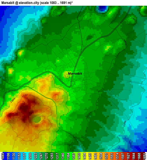
Below is the Elevation map of Marsabit, which displays elevation range with different colors. Scale of the first map is from 1083 to 1691 m (3553 to 5548 ft) with average elevation of 1316.3 meters (=4319 ft) [note 1]
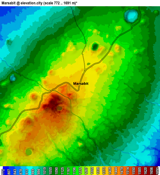
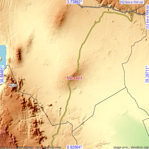
These maps also provides idea of topography and contour of this city, they are displayed at different zoom levels. More info about maps, scale and edge coordinates you can find below images.
| \ | Map #1 | Map #2 | Topo.Map |
| Scale [m] | 1083..1691 m | 772..1691 m | × |
| Scale [ft] | 3553..5548 ft | 2533..5548 ft | × |
| Average | 1316.3 m = 4319 ft | 1167.6 m = 3831 ft | × |
| Width | 9.76 km = 6.1 mi | 19.53 km = 12.1 mi | 312.4 km = 194.1 mi |
| Height | 9.76 km = 6.1 mi | 19.53 km = 12.1 mi | 312.5 km = 194.2 mi |
| ↑Max Latitude | 2.378588° | 2.422495° | 3.73892° |
| Latitude at center | 2.33468° | 2.33468° | 2.33468° |
| ↓Min Latitude | 2.29077° | 2.24686° | 0.92904° |
| ← Min Longitude | 37.946915° | 37.902969° | 36.58461° |
| Longitude center | 37.99086° | 37.99086° | 37.99086° |
| →Max Longitude | 38.034805° | 38.078751° | 39.39711° |
Nearby cities:
Cities around Marsabit sort by population:
• Meru elevation 1579 m
257.2 km,  188°
188°
• Wajir 258 m
238.7 km,  105°
105°
• Nanyuki 2001 m
278.2 km,  201°
201°
• Moyale 974 m
177.6 km,  41°
41°
• Isiolo 1095 m
224.8 km, 191°
• Maralal 1941 m
199 km,  226°
226°
• Lodwar 500 m
279.9 km,  288°
288°
• Maua 1655 m
233.7 km,  181°
181°
• Chuka 1452 m
299.1 km, 187°
• Naro Moru 2024 m
298.1 km, 201°
• Rumuruti 1846 m
280.5 km,  215°
215°
• Kathwana 722 m
296.8 km, 182°
Multilingual:
 En español:
Marsabit elevación 1364 m.
 En France:
Marsabit élévation 1364 m.
 Auf Deutsch:
Marsabit höhe über dem Meeresspiegel ist 1364 m.

Sources and notes:
- [note 1] Map square and city borders are not equal. Map elevation data is calculated only from area inside that square.
- [src 1] Elevation data from geonames database provided with same terms of usage.
- [src 2] The elevation map of Marsabit is generated using elevation data from NASA's 3 arcsec (90m) resolution SRTM data.
- [src 3] Base (background) map © OpenStreetMap contributors tiles are generated by Geofabrik and OpenTopoMap.
Copyright & License:
This Marsabit Elevation Map is licensed under CC BY-SA. You may reuse any part from this page, if you give a proper credit by linking to this URL:
 More info on terms of use page.