Narok elevation
Narok, Kenya elevation is 1881 meters and Narok elevation in feet is 6171 ft above sea level [src 1]. Narok is a seat of a first-order administrative division (feature code) with elevation that is 535 meters (1755 ft) bigger than average city elevation in Kenya.
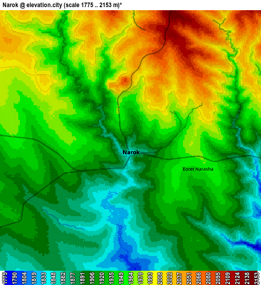
Below is the Elevation map of Narok, which displays elevation range with different colors. Scale of the first map is from 1824 to 2085 m (5984 to 6841 ft) with average elevation of 1934 meters (=6345 ft) [note 1]
These maps also provides idea of topography and contour of this city, they are displayed at different zoom levels. More info about maps, scale and edge coordinates you can find below images.

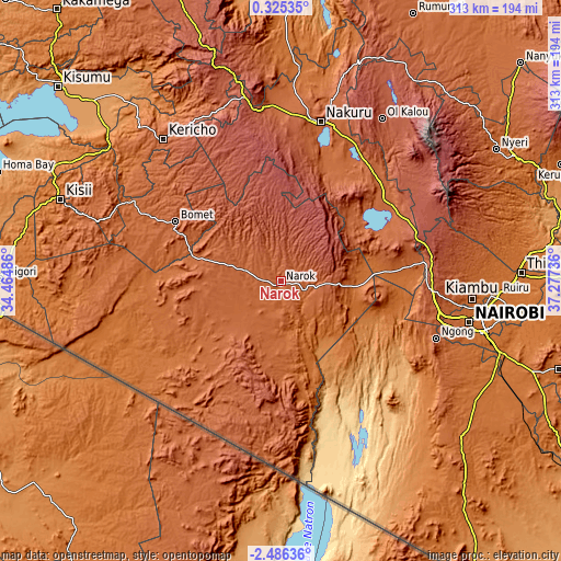
| \ | Map #1 | Map #2 | Topo.Map |
| Scale [m] | 1824..2085 m | 1775..2153 m | × |
| Scale [ft] | 5984..6841 ft | 5823..7064 ft | × |
| Average | 1934 m = 6345 ft | 1943.3 m = 6376 ft | × |
| Width | 9.77 km = 6.1 mi | 19.54 km = 12.1 mi | 312.6 km = 194.2 mi |
| Height | 9.77 km = 6.1 mi | 19.54 km = 12.1 mi | 312.7 km = 194.3 mi |
| ↑Max Latitude | -1.036892° | -0.992954° | 0.32535° |
| Latitude at center | -1.08083° | -1.08083° | -1.08083° |
| ↓Min Latitude | -1.124767° | -1.168704° | -2.48636° |
| ← Min Longitude | 35.827165° | 35.783219° | 34.46486° |
| Longitude center | 35.87111° | 35.87111° | 35.87111° |
| →Max Longitude | 35.915055° | 35.959001° | 37.27736° |
Nearby cities:
Cities around Narok sort by population:
• Nakuru elevation 1857 m
88.9 km,  14°
14°
• Naivasha 2084 m
74.6 km,  56°
56°
• Rongai 1874 m
100.9 km,  359°
359°
• Molo 2514 m
93.8 km,  350°
350°
• Magadi 617 m
102.3 km,  153°
153°
• Ngong 1930 m
93.8 km,  108°
108°
• Limuru 2248 m
85.8 km,  92°
92°
• Sotik Post 1959 m
67.6 km,  299°
299°
• Kijabe 2050 m
79.7 km,  78°
78°
• Kikuyu 2046 m
89.9 km,  101°
101°
• Litein 1940 m
93.9 km,  306°
306°
• Sotik 1779 m
95 km, 297°
Multilingual:
 En español:
Narok elevación 1881 m.
 En France:
Narok élévation 1881 m.


Sources and notes:
- [note 1] Map square and city borders are not equal. Map elevation data is calculated only from area inside that square.
- [src 1] Elevation data from geonames database provided with same terms of usage.
- [src 2] The elevation map of Narok is generated using elevation data from NASA's 3 arcsec (90m) resolution SRTM data.
- [src 3] Base (background) map © OpenStreetMap contributors tiles are generated by Geofabrik and OpenTopoMap.
Copyright & License:
This Narok Elevation Map is licensed under CC BY-SA. You may reuse any part from this page, if you give a proper credit by linking to this URL:
 More info on terms of use page.