Ngong elevation
Ngong (Kajiado), Kenya elevation is 1930 meters and Ngong elevation in feet is 6332 ft above sea level [src 1]. Ngong is a populated place (feature code) with elevation that is 584 meters (1916 ft) bigger than average city elevation in Kenya.
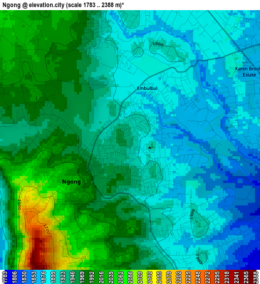
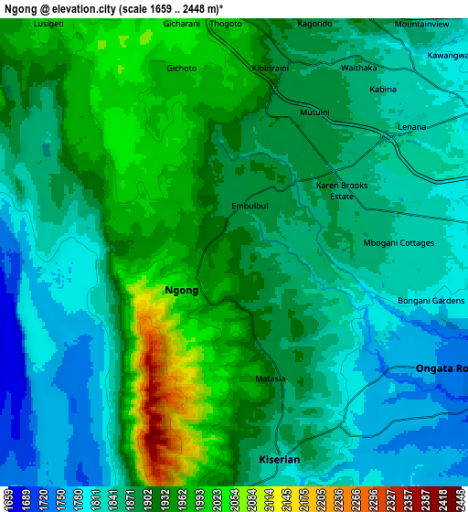
Below is the Elevation map of Ngong, which displays elevation range with different colors. Scale of the first map is from 1783 to 2388 m (5850 to 7835 ft) with average elevation of 1939 meters (=6362 ft) [note 1]
These maps also provides idea of topography and contour of this city, they are displayed at different zoom levels. More info about maps, scale and edge coordinates you can find below images.
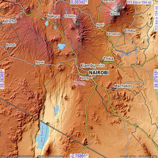
| \ | Map #1 | Map #2 | Topo.Map |
| Scale [m] | 1783..2388 m | 1659..2448 m | × |
| Scale [ft] | 5850..7835 ft | 5443..8031 ft | × |
| Average | 1939 m = 6362 ft | 1886.3 m = 6189 ft | × |
| Width | 9.77 km = 6.1 mi | 19.54 km = 12.1 mi | 312.6 km = 194.2 mi |
| Height | 9.77 km = 6.1 mi | 19.54 km = 12.1 mi | 312.6 km = 194.2 mi |
| ↑Max Latitude | -1.308767° | -1.264832° | 0.05342° |
| Latitude at center | -1.3527° | -1.3527° | -1.3527° |
| ↓Min Latitude | -1.396633° | -1.440565° | -2.75801° |
| ← Min Longitude | 36.625955° | 36.582009° | 35.26365° |
| Longitude center | 36.6699° | 36.6699° | 36.6699° |
| →Max Longitude | 36.713845° | 36.757791° | 38.07615° |
Nearby cities:
Cities around Ngong sort by population:
• Nairobi elevation 1684 m
18 km,  64°
64°
• Thika 1506 m
56.9 km,  51°
51°
• Machakos 1619 m
68.8 km,  105°
105°
• Pumwani 1645 m
21.5 km,  68°
68°
• Athi River 1505 m
36.2 km, 108°
• Kiambu 1683 m
27.3 km,  42°
42°
• Magadi 617 m
74.4 km,  214°
214°
• Kajiado 1725 m
56.8 km,  167°
167°
• Limuru 2248 m
26.8 km,  353°
353°
• Kijabe 2050 m
47.9 km, 346°
• Kikuyu 2046 m
11.9 km,  356°
356°
• Konza 1596 m
67 km,  129°
129°
Multilingual:
 En español:
Ngong elevación 1930 m.
 En France:
Ngong élévation 1930 m.


Sources and notes:
- [note 1] Map square and city borders are not equal. Map elevation data is calculated only from area inside that square.
- [src 1] Elevation data from geonames database provided with same terms of usage.
- [src 2] The elevation map of Ngong is generated using elevation data from NASA's 3 arcsec (90m) resolution SRTM data.
- [src 3] Base (background) map © OpenStreetMap contributors tiles are generated by Geofabrik and OpenTopoMap.
Copyright & License:
This Ngong Elevation Map is licensed under CC BY-SA. You may reuse any part from this page, if you give a proper credit by linking to this URL:
 More info on terms of use page.