Nayoro elevation
Nayoro (Hokkaido, Nayoro Shi), Japan elevation is 97 meters and Nayoro elevation in feet is 318 ft above sea level [src 1]. Nayoro is a seat of a second-order administrative division (feature code) with elevation that is 12 meters (39 ft) bigger than average city elevation in Japan.
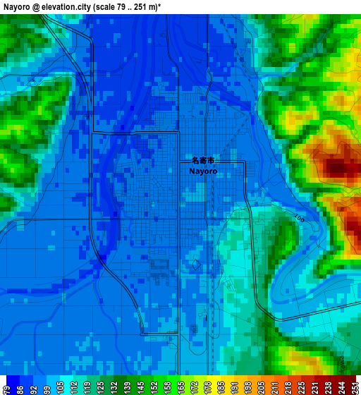
Below is the Elevation map of Nayoro, which displays elevation range with different colors. Scale of the first map is from 79 to 251 m (259 to 823 ft) with average elevation of 112.4 meters (=369 ft) [note 1]
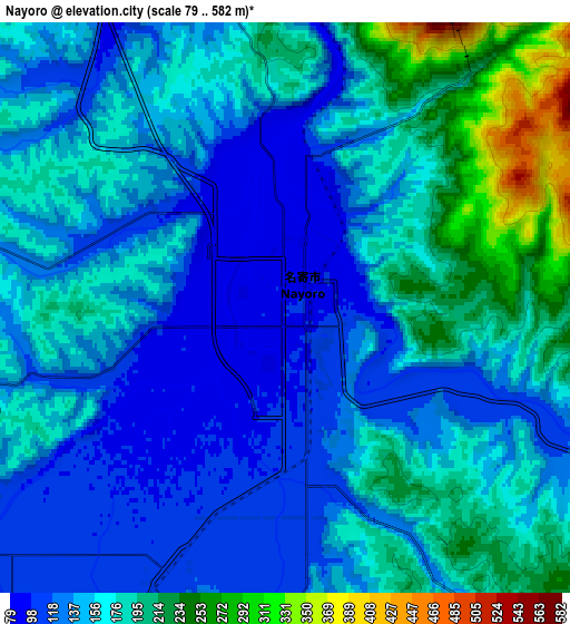
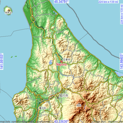
These maps also provides idea of topography and contour of this city, they are displayed at different zoom levels. More info about maps, scale and edge coordinates you can find below images.
| \ | Map #1 | Map #2 | Topo.Map |
| Scale [m] | 79..251 m | 79..582 m | × |
| Scale [ft] | 259..823 ft | 259..1909 ft | × |
| Average | 112.4 m = 369 ft | 159.6 m = 524 ft | × |
| Width | 6.99 km = 4.3 mi | 13.98 km = 8.7 mi | 223.6 km = 138.9 mi |
| Height | 6.99 km = 4.3 mi | 13.98 km = 8.7 mi | 223.6 km = 138.9 mi |
| ↑Max Latitude | 44.381976° | 44.413375° | 45.34751° |
| Latitude at center | 44.35056° | 44.35056° | 44.35056° |
| ↓Min Latitude | 44.319127° | 44.287678° | 43.33636° |
| ← Min Longitude | 142.413835° | 142.369889° | 141.05153° |
| Longitude center | 142.45778° | 142.45778° | 142.45778° |
| →Max Longitude | 142.501725° | 142.545671° | 143.86403° |
Nearby cities:
Cities around Nayoro sort by population:
• Asahikawa elevation 121 m
64.9 km,  186°
186°
• Takikawa 31 m
99.1 km,  206°
206°
• Mombetsu 16 m
71.1 km,  89°
89°
• Rumoi 35 m
79.8 km,  234°
234°
• Fukagawa 40 m
78.9 km, 205°
• Sunagawa 33 m
105.8 km,  204°
204°
• Ashibetsu 111 m
96 km, 193°
• Akabira 57 m
94.6 km, 200°
• Kamikawa 332 m
62 km,  156°
156°
• Utashinai 169 m
98.3 km, 199°
• Mobetsu 21 m
72.3 km,  97°
97°
• Shibetsu 127 m
20.5 km, 194°
Multilingual:
 En español:
Nayoro elevación 97 m.
 En France:
Nayoro élévation 97 m.


Sources and notes:
- [note 1] Map square and city borders are not equal. Map elevation data is calculated only from area inside that square.
- [src 1] Elevation data from geonames database provided with same terms of usage.
- [src 2] The elevation map of Nayoro is generated using elevation data from NASA's 3 arcsec (90m) resolution SRTM data.
- [src 3] Base (background) map © OpenStreetMap contributors tiles are generated by Geofabrik and OpenTopoMap.
Copyright & License:
This Nayoro Elevation Map is licensed under CC BY-SA. You may reuse any part from this page, if you give a proper credit by linking to this URL:
 More info on terms of use page.