Nihommatsu elevation
Nihommatsu (Fukushima, Nihonmatsu Shi), Japan elevation is 224 meters and Nihommatsu elevation in feet is 735 ft above sea level [src 1]. Nihommatsu is a seat of a second-order administrative division (feature code) with elevation that is 139 meters (456 ft) bigger than average city elevation in Japan.
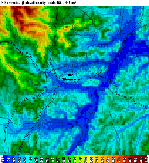
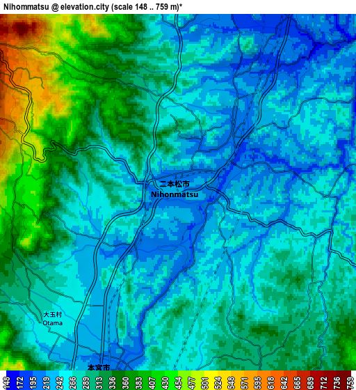
Below is the Elevation map of Nihommatsu, which displays elevation range with different colors. Scale of the first map is from 188 to 415 m (617 to 1362 ft) with average elevation of 242.1 meters (=794 ft) [note 1]
These maps also provides idea of topography and contour of this city, they are displayed at different zoom levels. More info about maps, scale and edge coordinates you can find below images.
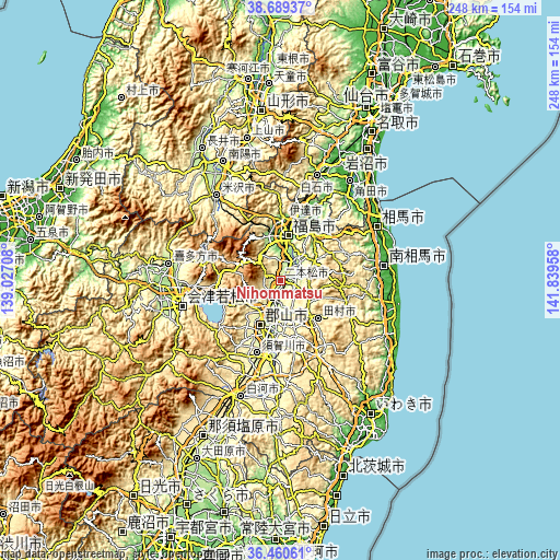
| \ | Map #1 | Map #2 | Topo.Map |
| Scale [m] | 188..415 m | 148..759 m | × |
| Scale [ft] | 617..1362 ft | 486..2490 ft | × |
| Average | 242.1 m = 794 ft | 289.1 m = 948 ft | × |
| Width | 7.74 km = 4.8 mi | 15.49 km = 9.6 mi | 247.8 km = 154 mi |
| Height | 7.74 km = 4.8 mi | 15.49 km = 9.6 mi | 247.8 km = 154 mi |
| ↑Max Latitude | 37.618147° | 37.652948° | 38.68937° |
| Latitude at center | 37.58333° | 37.58333° | 37.58333° |
| ↓Min Latitude | 37.548497° | 37.513647° | 36.46061° |
| ← Min Longitude | 140.389385° | 140.345439° | 139.02708° |
| Longitude center | 140.43333° | 140.43333° | 140.43333° |
| →Max Longitude | 140.477275° | 140.521221° | 141.83958° |
Nearby cities:
Cities around Nihommatsu sort by population:
• Kōriyama elevation 236 m
20.9 km,  192°
192°
• Fukushima 77 m
18.8 km,  8°
8°
• Sukagawa 261 m
33.6 km, 187°
• Hobaramachi 51 m
27.9 km,  21°
21°
• Funehikimachi-funehiki 441 m
19.7 km,  140°
140°
• Motomiya 213 m
8.2 km,  200°
200°
• Yanagawamachi-saiwaichō 44 m
33.1 km,  26°
26°
• Miharu 352 m
17.3 km,  165°
165°
• Inawashiro 532 m
28 km,  266°
266°
• Aizu-Wakamatsu 238 m
44.2 km,  256°
256°
• Date 58 m
26.6 km, 12°
• Tamura 468 m
22.7 km, 138°
Multilingual:
 En español:
Nihommatsu elevación 224 m.
 En France:
Nihommatsu élévation 224 m.
 Auf Deutsch:
Nihommatsu höhe über dem Meeresspiegel ist 224 m.

Sources and notes:
- [note 1] Map square and city borders are not equal. Map elevation data is calculated only from area inside that square.
- [src 1] Elevation data from geonames database provided with same terms of usage.
- [src 2] The elevation map of Nihommatsu is generated using elevation data from NASA's 3 arcsec (90m) resolution SRTM data.
- [src 3] Base (background) map © OpenStreetMap contributors tiles are generated by Geofabrik and OpenTopoMap.
Copyright & License:
This Nihommatsu Elevation Map is licensed under CC BY-SA. You may reuse any part from this page, if you give a proper credit by linking to this URL:
 More info on terms of use page.