Saijō elevation
Saijō (Ehime, Saijō-shi), Japan elevation is 8 meters and Saijō elevation in feet is 26 ft above sea level [src 1]. Saijō is a seat of a second-order administrative division (feature code) with elevation that is 77 meters (253 ft) smaller than average city elevation in Japan.
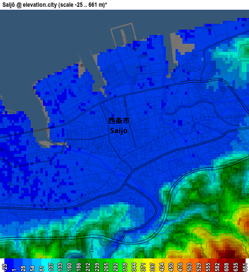
Below is the Elevation map of Saijō, which displays elevation range with different colors. Scale of the first map is from -25 to 661 m (-82 to 2169 ft) with average elevation of 63.4 meters (=208 ft) [note 1]
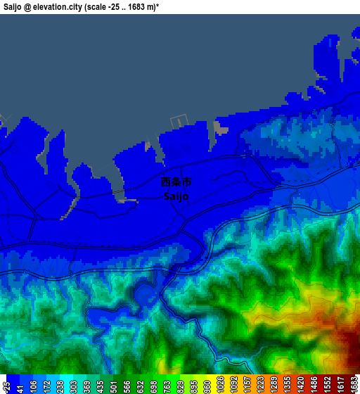
These maps also provides idea of topography and contour of this city, they are displayed at different zoom levels. More info about maps, scale and edge coordinates you can find below images.
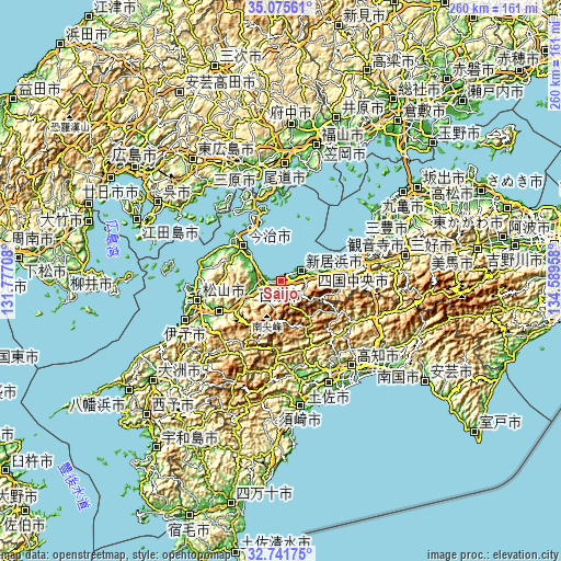
| \ | Map #1 | Map #2 | Topo.Map |
| Scale [m] | -25..661 m | -25..1683 m | × |
| Scale [ft] | -82..2169 ft | -82..5522 ft | × |
| Average | 63.4 m = 208 ft | 259.9 m = 853 ft | × |
| Width | 8.11 km = 5 mi | 16.22 km = 10.1 mi | 259.5 km = 161.2 mi |
| Height | 8.11 km = 5 mi | 16.22 km = 10.1 mi | 259.5 km = 161.2 mi |
| ↑Max Latitude | 33.95313° | 33.989575° | 35.07561° |
| Latitude at center | 33.91667° | 33.91667° | 33.91667° |
| ↓Min Latitude | 33.880194° | 33.843703° | 32.74175° |
| ← Min Longitude | 133.139385° | 133.095439° | 131.77708° |
| Longitude center | 133.18333° | 133.18333° | 133.18333° |
| →Max Longitude | 133.227275° | 133.271221° | 134.58958° |
Nearby cities:
Cities around Saijō sort by population:
• Matsuyama elevation 28 m
39.5 km,  257°
257°
• Niihama 13 m
12.3 km,  66°
66°
• Kawanoechō 13 m
38.1 km, 73°
• Iyo 14 m
48.2 km,  247°
247°
• Masaki-chō 7 m
45.9 km, 251°
• Hōjō 7 m
38 km,  280°
280°
• Innoshima 33 m
40.8 km,  0°
0°
• Ino 29 m
46.9 km,  150°
150°
• Kan’onji 19 m
46.2 km, 68°
• Shikokuchūō 41 m
34.4 km,  79°
79°
• Tōon 121 m
30.3 km,  243°
243°
• Imabari-shi 6 m
24 km,  315°
315°
Multilingual:
 En español:
Saijō elevación 8 m.
 En France:
Saijō élévation 8 m.


Sources and notes:
- [note 1] Map square and city borders are not equal. Map elevation data is calculated only from area inside that square.
- [src 1] Elevation data from geonames database provided with same terms of usage.
- [src 2] The elevation map of Saijō is generated using elevation data from NASA's 3 arcsec (90m) resolution SRTM data.
- [src 3] Base (background) map © OpenStreetMap contributors tiles are generated by Geofabrik and OpenTopoMap.
Copyright & License:
This Saijō Elevation Map is licensed under CC BY-SA. You may reuse any part from this page, if you give a proper credit by linking to this URL:
 More info on terms of use page.