Fukayachō elevation
Fukayachō (Saitama, Fukaya-shi), Japan elevation is 35 meters and Fukayachō elevation in feet is 115 ft above sea level [src 1]. Fukayachō is a historical populated place (feature code) with elevation that is 50 meters (164 ft) smaller than average city elevation in Japan.
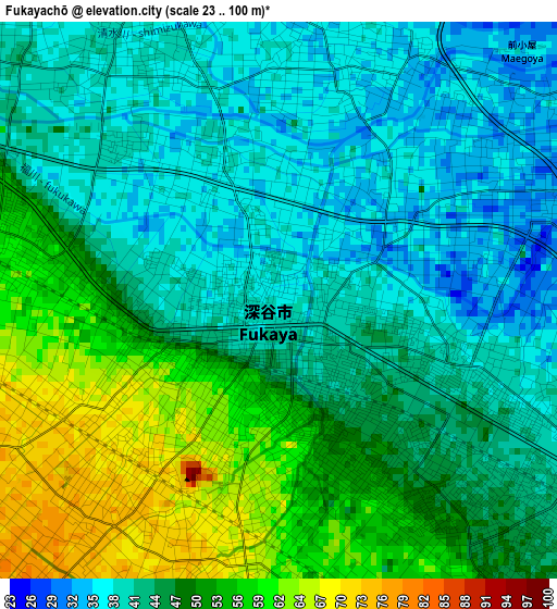
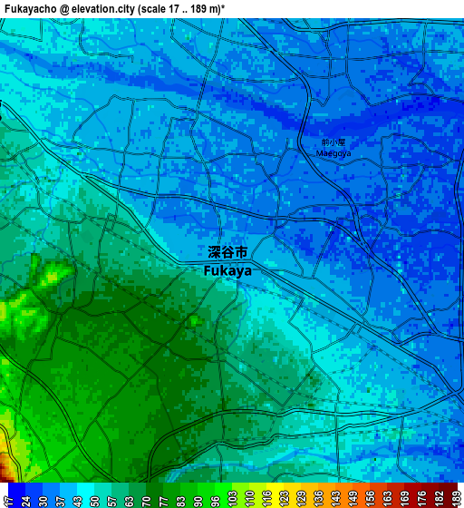
Below is the Elevation map of Fukayachō, which displays elevation range with different colors. Scale of the first map is from 23 to 100 m (75 to 328 ft) with average elevation of 46.1 meters (=151 ft) [note 1]
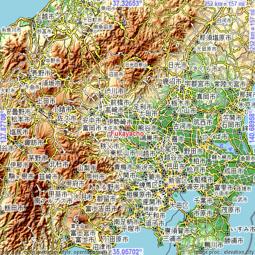
These maps also provides idea of topography and contour of this city, they are displayed at different zoom levels. More info about maps, scale and edge coordinates you can find below images.
| \ | Map #1 | Map #2 | Topo.Map |
| Scale [m] | 23..100 m | 17..189 m | × |
| Scale [ft] | 75..328 ft | 56..620 ft | × |
| Average | 46.1 m = 151 ft | 49 m = 161 ft | × |
| Width | 7.89 km = 4.9 mi | 15.77 km = 9.8 mi | 252.3 km = 156.8 mi |
| Height | 7.89 km = 4.9 mi | 15.77 km = 9.8 mi | 252.3 km = 156.8 mi |
| ↑Max Latitude | 36.235454° | 36.270892° | 37.32653° |
| Latitude at center | 36.2° | 36.2° | 36.2° |
| ↓Min Latitude | 36.16453° | 36.129044° | 35.05702° |
| ← Min Longitude | 139.239385° | 139.195439° | 137.87708° |
| Longitude center | 139.28333° | 139.28333° | 139.28333° |
| →Max Longitude | 139.327275° | 139.371221° | 140.68958° |
Nearby cities:
Cities around Fukayachō sort by population:
• Kumagaya elevation 32 m
12 km,  127°
127°
• Ōta 50 m
13.4 km,  33°
33°
• Isesaki 62 m
15 km,  330°
330°
• Gyōda 25 m
17.2 km,  112°
112°
• Honjō 59 m
9.3 km,  296°
296°
• Yorii 102 m
12.3 km,  220°
220°
• Ogawa 90 m
16.4 km,  185°
185°
• Sakai-nakajima 43 m
8 km,  338°
338°
• Fukiage-fujimi 20 m
18.6 km, 126°
• Menuma 29 m
9.2 km,  74°
74°
• Kodamachō-kodamaminami 106 m
13.7 km,  262°
262°
• Fukaya 72 m
3.3 km, 219°
Multilingual:
 En español:
Fukayachō elevación 35 m.
 En France:
Fukayachō élévation 35 m.
 Auf Deutsch:
Fukayachō höhe über dem Meeresspiegel ist 35 m.

Sources and notes:
- [note 1] Map square and city borders are not equal. Map elevation data is calculated only from area inside that square.
- [src 1] Elevation data from geonames database provided with same terms of usage.
- [src 2] The elevation map of Fukayachō is generated using elevation data from NASA's 3 arcsec (90m) resolution SRTM data.
- [src 3] Base (background) map © OpenStreetMap contributors tiles are generated by Geofabrik and OpenTopoMap.
Copyright & License:
This Fukayachō Elevation Map is licensed under CC BY-SA. You may reuse any part from this page, if you give a proper credit by linking to this URL:
 More info on terms of use page.