Hondomachi-hondo elevation
Hondomachi-hondo (Kumamoto, Amakusa Shi), Japan elevation is 16 meters and Hondomachi-hondo elevation in feet is 52 ft above sea level [src 1]. Hondomachi-hondo is a populated place (feature code) with elevation that is 69 meters (226 ft) smaller than average city elevation in Japan.
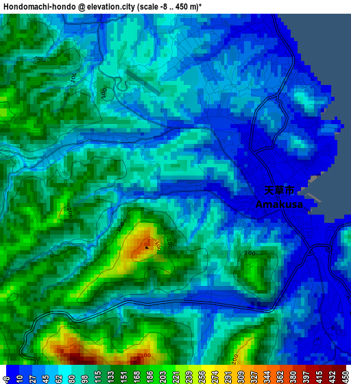
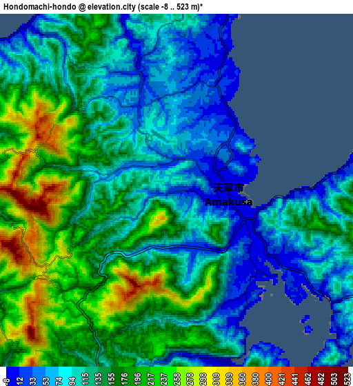
Below is the Elevation map of Hondomachi-hondo, which displays elevation range with different colors. Scale of the first map is from -8 to 450 m (-26 to 1476 ft) with average elevation of 85.9 meters (=282 ft) [note 1]
These maps also provides idea of topography and contour of this city, they are displayed at different zoom levels. More info about maps, scale and edge coordinates you can find below images.
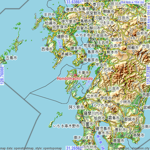
| \ | Map #1 | Map #2 | Topo.Map |
| Scale [m] | -8..450 m | -8..523 m | × |
| Scale [ft] | -26..1476 ft | -26..1716 ft | × |
| Average | 85.9 m = 282 ft | 138 m = 453 ft | × |
| Width | 8.25 km = 5.1 mi | 16.49 km = 10.2 mi | 263.9 km = 164 mi |
| Height | 8.25 km = 5.1 mi | 16.49 km = 10.2 mi | 263.9 km = 164 mi |
| ↑Max Latitude | 32.497002° | 32.534059° | 33.63861° |
| Latitude at center | 32.45993° | 32.45993° | 32.45993° |
| ↓Min Latitude | 32.422843° | 32.38574° | 31.26562° |
| ← Min Longitude | 130.123185° | 130.079239° | 128.76088° |
| Longitude center | 130.16713° | 130.16713° | 130.16713° |
| →Max Longitude | 130.211075° | 130.255021° | 131.57338° |
Nearby cities:
Cities around Hondomachi-hondo sort by population:
• Nagasaki elevation 15 m
41.8 km,  320°
320°
• Honmachi 6 m
40.9 km,  83°
83°
• Isahaya 104 m
43.9 km,  344°
344°
• Izumi 37 m
45.9 km,  155°
155°
• Shimabara 11 m
40.5 km,  27°
27°
• Minamata 2 m
34.8 km,  141°
141°
• Ushibukamachi 109 m
31.8 km,  205°
205°
• Yatsushiro 0 m
46.8 km, 76°
• Unzen 546 m
35.4 km,  12°
12°
• Minamishimabara 129 m
25.5 km,  21°
21°
• Kamiamakusa 11 m
21.6 km, 81°
• Amakusa 6 m
2.4 km,  93°
93°
Multilingual:
 En español:
Hondomachi-hondo elevación 16 m.
 En France:
Hondomachi-hondo élévation 16 m.
 Auf Deutsch:
Hondomachi-hondo höhe über dem Meeresspiegel ist 16 m.

Sources and notes:
- [note 1] Map square and city borders are not equal. Map elevation data is calculated only from area inside that square.
- [src 1] Elevation data from geonames database provided with same terms of usage.
- [src 2] The elevation map of Hondomachi-hondo is generated using elevation data from NASA's 3 arcsec (90m) resolution SRTM data.
- [src 3] Base (background) map © OpenStreetMap contributors tiles are generated by Geofabrik and OpenTopoMap.
Copyright & License:
This Hondomachi-hondo Elevation Map is licensed under CC BY-SA. You may reuse any part from this page, if you give a proper credit by linking to this URL:
 More info on terms of use page.