Iwata elevation
Iwata (Shizuoka, Iwata-shi), Japan elevation is 5 meters and Iwata elevation in feet is 16 ft above sea level [src 1]. Iwata is a seat of a second-order administrative division (feature code) with elevation that is 80 meters (262 ft) smaller than average city elevation in Japan.
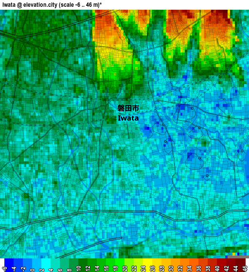
Below is the Elevation map of Iwata, which displays elevation range with different colors. Scale of the first map is from -6 to 46 m (-20 to 151 ft) with average elevation of 6.9 meters (=23 ft) [note 1]
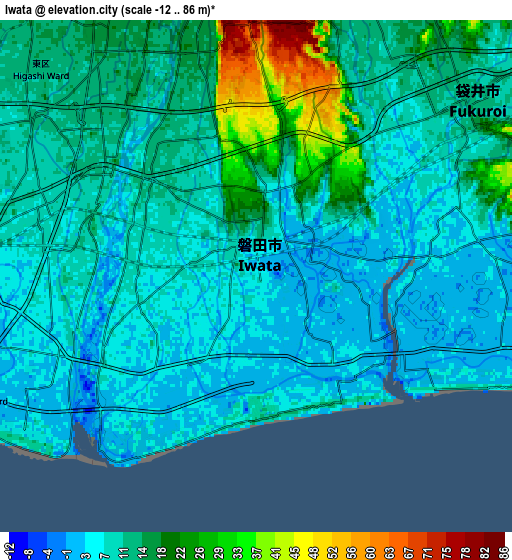
These maps also provides idea of topography and contour of this city, they are displayed at different zoom levels. More info about maps, scale and edge coordinates you can find below images.
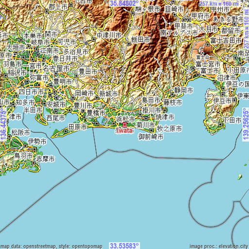
| \ | Map #1 | Map #2 | Topo.Map |
| Scale [m] | -6..46 m | -12..86 m | × |
| Scale [ft] | -20..151 ft | -39..282 ft | × |
| Average | 6.9 m = 23 ft | 11.1 m = 36 ft | × |
| Width | 8.03 km = 5 mi | 16.07 km = 10 mi | 257.1 km = 159.8 mi |
| Height | 8.03 km = 5 mi | 16.07 km = 10 mi | 257.1 km = 159.8 mi |
| ↑Max Latitude | 34.736121° | 34.772227° | 35.84802° |
| Latitude at center | 34.7° | 34.7° | 34.7° |
| ↓Min Latitude | 34.663863° | 34.62771° | 33.53583° |
| ← Min Longitude | 137.806055° | 137.762109° | 136.44375° |
| Longitude center | 137.85° | 137.85° | 137.85° |
| →Max Longitude | 137.893945° | 137.937891° | 139.25625° |
Nearby cities:
Cities around Iwata sort by population:
• Hamamatsu elevation 3 m
10.7 km,  270°
270°
• Hamakita 21 m
12.7 km,  331°
331°
• Kakegawa 32 m
16.9 km,  64°
64°
• Shimada 105 m
33.1 km,  66°
66°
• Fukuroi 11 m
8.2 km,  47°
47°
• Sagara 10 m
32.5 km,  92°
92°
• Ōyama 50 m
35.3 km,  107°
107°
• Kanaya 106 m
28.7 km, 62°
• Mori 56 m
16.7 km,  27°
27°
• Kosai 30 m
29.9 km, 270°
• Makinohara 178 m
28.5 km, 73°
• Kikugawa 19 m
24.7 km, 89°
Multilingual:
 En español:
Iwata elevación 5 m.
 En France:
Iwata élévation 5 m.


Sources and notes:
- [note 1] Map square and city borders are not equal. Map elevation data is calculated only from area inside that square.
- [src 1] Elevation data from geonames database provided with same terms of usage.
- [src 2] The elevation map of Iwata is generated using elevation data from NASA's 3 arcsec (90m) resolution SRTM data.
- [src 3] Base (background) map © OpenStreetMap contributors tiles are generated by Geofabrik and OpenTopoMap.
Copyright & License:
This Iwata Elevation Map is licensed under CC BY-SA. You may reuse any part from this page, if you give a proper credit by linking to this URL:
 More info on terms of use page.