Kamojimachō-jōgejima elevation
Kamojimachō-jōgejima (Tokushima, Yoshinogawa Shi), Japan elevation is 14 meters and Kamojimachō-jōgejima elevation in feet is 46 ft above sea level [src 1]. Kamojimachō-jōgejima is a populated place (feature code) with elevation that is 71 meters (233 ft) smaller than average city elevation in Japan.
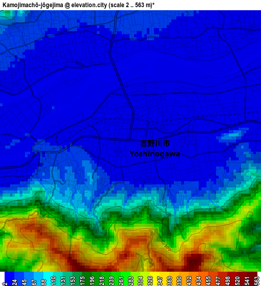
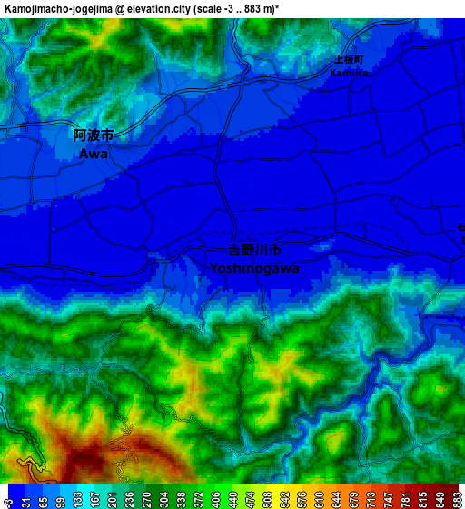
Below is the Elevation map of Kamojimachō-jōgejima, which displays elevation range with different colors. Scale of the first map is from 2 to 563 m (7 to 1847 ft) with average elevation of 98.4 meters (=323 ft) [note 1]
These maps also provides idea of topography and contour of this city, they are displayed at different zoom levels. More info about maps, scale and edge coordinates you can find below images.
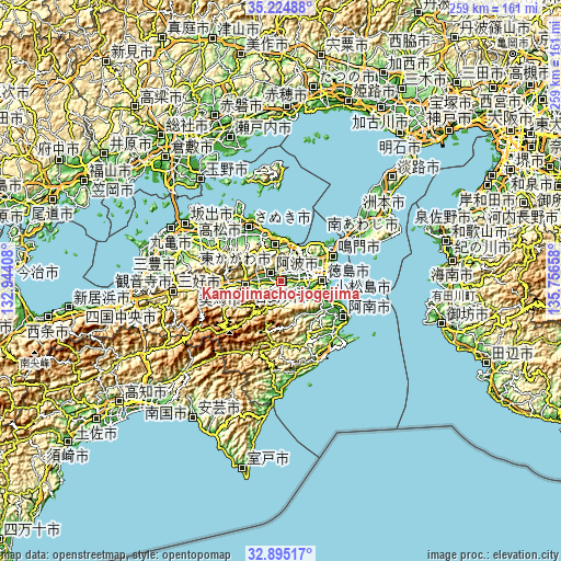
| \ | Map #1 | Map #2 | Topo.Map |
| Scale [m] | 2..563 m | -3..883 m | × |
| Scale [ft] | 7..1847 ft | -10..2897 ft | × |
| Average | 98.4 m = 323 ft | 168.5 m = 553 ft | × |
| Width | 8.1 km = 5 mi | 16.19 km = 10.1 mi | 259 km = 160.9 mi |
| Height | 8.1 km = 5 mi | 16.19 km = 10.1 mi | 259 km = 160.9 mi |
| ↑Max Latitude | 34.104425° | 34.140805° | 35.22488° |
| Latitude at center | 34.06803° | 34.06803° | 34.06803° |
| ↓Min Latitude | 34.031619° | 33.995193° | 32.89517° |
| ← Min Longitude | 134.306385° | 134.262439° | 132.94408° |
| Longitude center | 134.35033° | 134.35033° | 134.35033° |
| →Max Longitude | 134.394275° | 134.438221° | 135.75658° |
Nearby cities:
Cities around Kamojimachō-jōgejima sort by population:
• Tokushima elevation 3 m
19.9 km,  90°
90°
• Narutochō-mitsuishi 2 m
28 km,  58°
58°
• Anan 12 m
32.3 km,  121°
121°
• Komatsushimachō 3 m
22.8 km,  109°
109°
• Ishii 10 m
8.5 km, 90°
• Shido 6 m
32.7 km,  330°
330°
• Wakimachi 52 m
18.5 km,  269°
269°
• Sanuki 35 m
24.7 km, 333°
• Mima 45 m
19.5 km, 265°
• Higashikagawa 59 m
15.9 km,  355°
355°
• Awa 49 m
6.6 km,  293°
293°
• Yoshinogawa 309 m
6.3 km,  238°
238°
Multilingual:
 En español:
Kamojimachō-jōgejima elevación 14 m.
 En France:
Kamojimachō-jōgejima élévation 14 m.
 Auf Deutsch:
Kamojimachō-jōgejima höhe über dem Meeresspiegel ist 14 m.
 На русском:
Kamojimachō-jōgejima высота над уровнем моря 14 м
Sources and notes:
- [note 1] Map square and city borders are not equal. Map elevation data is calculated only from area inside that square.
- [src 1] Elevation data from geonames database provided with same terms of usage.
- [src 2] The elevation map of Kamojimachō-jōgejima is generated using elevation data from NASA's 3 arcsec (90m) resolution SRTM data.
- [src 3] Base (background) map © OpenStreetMap contributors tiles are generated by Geofabrik and OpenTopoMap.
Copyright & License:
This Kamojimachō-jōgejima Elevation Map is licensed under CC BY-SA. You may reuse any part from this page, if you give a proper credit by linking to this URL:
 More info on terms of use page.