Miyoshi elevation
Miyoshi (Hiroshima, Miyoshi Shi), Japan elevation is 154 meters and Miyoshi elevation in feet is 505 ft above sea level [src 1]. Miyoshi is a seat of a second-order administrative division (feature code) with elevation that is 69 meters (226 ft) bigger than average city elevation in Japan.
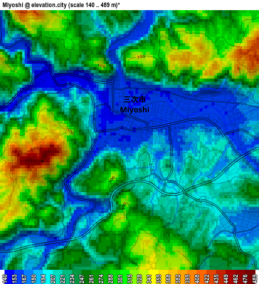
Below is the Elevation map of Miyoshi, which displays elevation range with different colors. Scale of the first map is from 140 to 489 m (459 to 1604 ft) with average elevation of 240.6 meters (=789 ft) [note 1]
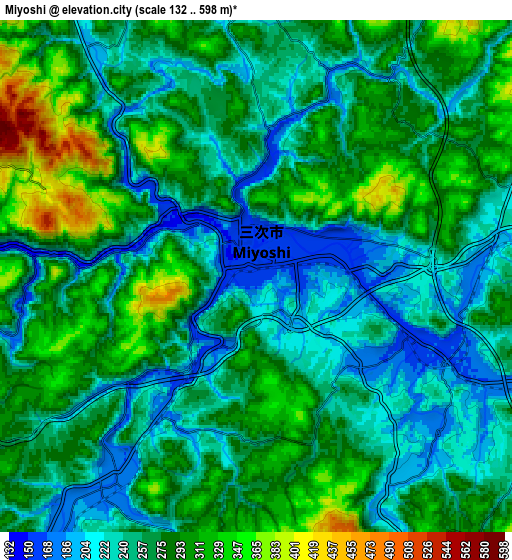
These maps also provides idea of topography and contour of this city, they are displayed at different zoom levels. More info about maps, scale and edge coordinates you can find below images.
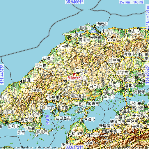
| \ | Map #1 | Map #2 | Topo.Map |
| Scale [m] | 140..489 m | 132..598 m | × |
| Scale [ft] | 459..1604 ft | 433..1962 ft | × |
| Average | 240.6 m = 789 ft | 267.1 m = 876 ft | × |
| Width | 8.02 km = 5 mi | 16.05 km = 10 mi | 256.8 km = 159.6 mi |
| Height | 8.02 km = 5 mi | 16.05 km = 10 mi | 256.8 km = 159.6 mi |
| ↑Max Latitude | 34.836078° | 34.87214° | 35.94661° |
| Latitude at center | 34.8° | 34.8° | 34.8° |
| ↓Min Latitude | 34.763906° | 34.727797° | 33.63721° |
| ← Min Longitude | 132.806055° | 132.762109° | 131.44375° |
| Longitude center | 132.85° | 132.85° | 132.85° |
| →Max Longitude | 132.893945° | 132.937891° | 134.25625° |
Nearby cities:
Cities around Miyoshi sort by population:
• Hiroshima elevation 16 m
57.6 km,  219°
219°
• Onomichi 52 m
53.3 km,  143°
143°
• Mihara 11 m
49.3 km,  154°
154°
• Fuchūchō 33 m
43.3 km,  125°
125°
• Ōdachō-ōda 27 m
53.4 km,  324°
324°
• Takehara 19 m
51.7 km,  173°
173°
• Shin’ichi 23 m
47.3 km, 125°
• Shōbara 253 m
16.2 km,  69°
69°
• Oda 18 m
54.8 km, 324°
• Unnan 82 m
49.5 km,  5°
5°
• Higashihiroshima 217 m
44.7 km,  193°
193°
• Aki-takata 220 m
20.8 km,  227°
227°
Multilingual:
 En español:
Miyoshi elevación 154 m.
 En France:
Miyoshi élévation 154 m.


Sources and notes:
- [note 1] Map square and city borders are not equal. Map elevation data is calculated only from area inside that square.
- [src 1] Elevation data from geonames database provided with same terms of usage.
- [src 2] The elevation map of Miyoshi is generated using elevation data from NASA's 3 arcsec (90m) resolution SRTM data.
- [src 3] Base (background) map © OpenStreetMap contributors tiles are generated by Geofabrik and OpenTopoMap.
Copyright & License:
This Miyoshi Elevation Map is licensed under CC BY-SA. You may reuse any part from this page, if you give a proper credit by linking to this URL:
 More info on terms of use page.