Nagano elevation
Nagano, Japan elevation is 372 meters and Nagano elevation in feet is 1220 ft above sea level [src 1]. Nagano is a seat of a first-order administrative division (feature code) with elevation that is 287 meters (942 ft) bigger than average city elevation in Japan.
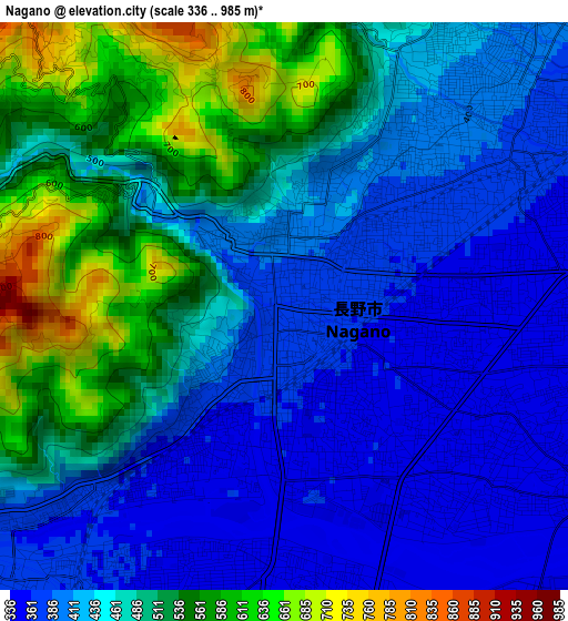
Below is the Elevation map of Nagano, which displays elevation range with different colors. Scale of the first map is from 336 to 985 m (1102 to 3232 ft) with average elevation of 459.1 meters (=1506 ft) [note 1]
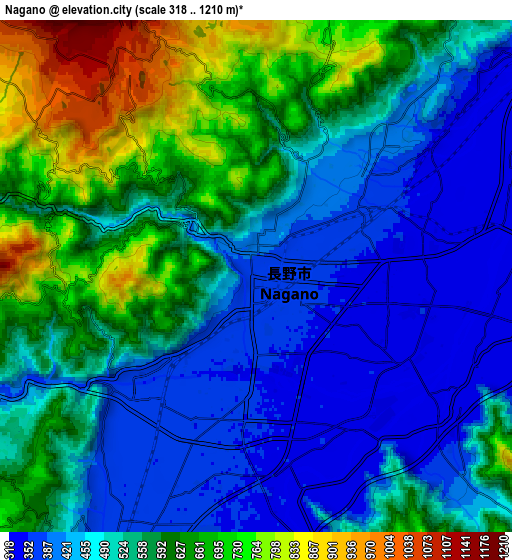
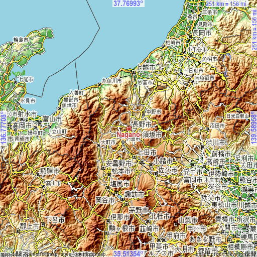
These maps also provides idea of topography and contour of this city, they are displayed at different zoom levels. More info about maps, scale and edge coordinates you can find below images.
| \ | Map #1 | Map #2 | Topo.Map |
| Scale [m] | 336..985 m | 318..1210 m | × |
| Scale [ft] | 1102..3232 ft | 1043..3970 ft | × |
| Average | 459.1 m = 1506 ft | 535.3 m = 1756 ft | × |
| Width | 7.84 km = 4.9 mi | 15.68 km = 9.7 mi | 250.9 km = 155.9 mi |
| Height | 7.84 km = 4.9 mi | 15.68 km = 9.7 mi | 250.9 km = 155.9 mi |
| ↑Max Latitude | 36.685249° | 36.720482° | 37.76993° |
| Latitude at center | 36.65° | 36.65° | 36.65° |
| ↓Min Latitude | 36.614735° | 36.579453° | 35.51354° |
| ← Min Longitude | 138.139385° | 138.095439° | 136.77708° |
| Longitude center | 138.18333° | 138.18333° | 138.18333° |
| →Max Longitude | 138.227275° | 138.271221° | 139.58958° |
Nearby cities:
Cities around Nagano sort by population:
• Ueda elevation 536 m
28.9 km,  162°
162°
• Suzaka 401 m
11.9 km,  90°
90°
• Komoro 686 m
43.3 km,  148°
148°
• Nakano 380 m
19.8 km,  55°
55°
• Ōmachi 714 m
32.8 km,  239°
239°
• Arai 175 m
39.2 km,  5°
5°
• Kamimaruko 563 m
37.7 km,  167°
167°
• Iiyama 311 m
27.6 km,  36°
36°
• Hakuba 702 m
29.2 km,  280°
280°
• Myoko 192 m
41.4 km, 11°
• Tōmi 639 m
36.4 km, 154°
• Chikuma 388 m
16 km,  211°
211°
Multilingual:
 En español:
Nagano elevación 372 m.
 En France:
Nagano élévation 372 m.


Sources and notes:
- [note 1] Map square and city borders are not equal. Map elevation data is calculated only from area inside that square.
- [src 1] Elevation data from geonames database provided with same terms of usage.
- [src 2] The elevation map of Nagano is generated using elevation data from NASA's 3 arcsec (90m) resolution SRTM data.
- [src 3] Base (background) map © OpenStreetMap contributors tiles are generated by Geofabrik and OpenTopoMap.
Copyright & License:
This Nagano Elevation Map is licensed under CC BY-SA. You may reuse any part from this page, if you give a proper credit by linking to this URL:
 More info on terms of use page.