Obita elevation
Obita (Nagasaki, Nishisonogi-gun), Japan elevation is 19 meters and Obita elevation in feet is 62 ft above sea level [src 1]. Obita is a populated place (feature code) with elevation that is 66 meters (217 ft) smaller than average city elevation in Japan.
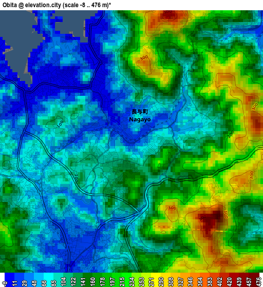
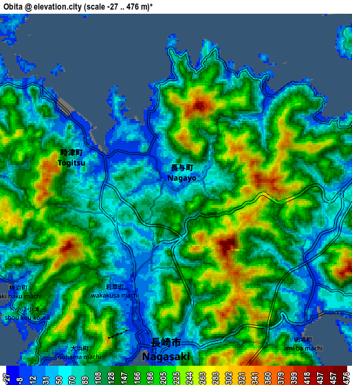
Below is the Elevation map of Obita, which displays elevation range with different colors. Scale of the first map is from -8 to 476 m (-26 to 1562 ft) with average elevation of 132.4 meters (=434 ft) [note 1]
These maps also provides idea of topography and contour of this city, they are displayed at different zoom levels. More info about maps, scale and edge coordinates you can find below images.
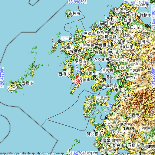
| \ | Map #1 | Map #2 | Topo.Map |
| Scale [m] | -8..476 m | -27..476 m | × |
| Scale [ft] | -26..1562 ft | -89..1562 ft | × |
| Average | 132.4 m = 434 ft | 132.4 m = 434 ft | × |
| Width | 8.21 km = 5.1 mi | 16.43 km = 10.2 mi | 262.8 km = 163.3 mi |
| Height | 8.21 km = 5.1 mi | 16.43 km = 10.2 mi | 262.8 km = 163.3 mi |
| ↑Max Latitude | 32.853594° | 32.890503° | 33.99059° |
| Latitude at center | 32.81667° | 32.81667° | 32.81667° |
| ↓Min Latitude | 32.77973° | 32.742775° | 31.62704° |
| ← Min Longitude | 129.839385° | 129.795439° | 128.47708° |
| Longitude center | 129.88333° | 129.88333° | 129.88333° |
| →Max Longitude | 129.927275° | 129.971221° | 131.28958° |
Nearby cities:
Cities around Obita sort by population:
• Nagasaki elevation 15 m
7.4 km,  180°
180°
• Sasebo 8 m
41.8 km,  339°
339°
• Isahaya 104 m
15.2 km,  79°
79°
• Ōmura 17 m
13.4 km,  29°
29°
• Kashima 20 m
37.5 km, 30°
• Togitsu 1 m
3.6 km,  300°
300°
• Ureshinomachi-shimojuku 56 m
34.8 km,  18°
18°
• Takeo 17 m
43.4 km, 16°
• Minamishimabara 129 m
39.3 km,  113°
113°
• Ureshino 9 m
39 km, 24°
• Unzen 546 m
34.5 km,  98°
98°
• Saikai 184 m
26.5 km,  314°
314°
Multilingual:
 En español:
Obita elevación 19 m.
 En France:
Obita élévation 19 m.


Sources and notes:
- [note 1] Map square and city borders are not equal. Map elevation data is calculated only from area inside that square.
- [src 1] Elevation data from geonames database provided with same terms of usage.
- [src 2] The elevation map of Obita is generated using elevation data from NASA's 3 arcsec (90m) resolution SRTM data.
- [src 3] Base (background) map © OpenStreetMap contributors tiles are generated by Geofabrik and OpenTopoMap.
Copyright & License:
This Obita Elevation Map is licensed under CC BY-SA. You may reuse any part from this page, if you give a proper credit by linking to this URL:
 More info on terms of use page.