Tsukawaki elevation
Tsukawaki (Oita, Kusu-gun), Japan elevation is 336 meters and Tsukawaki elevation in feet is 1102 ft above sea level [src 1]. Tsukawaki is a populated place (feature code) with elevation that is 251 meters (823 ft) bigger than average city elevation in Japan.
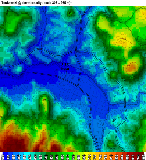
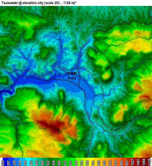
Below is the Elevation map of Tsukawaki, which displays elevation range with different colors. Scale of the first map is from 306 to 965 m (1004 to 3166 ft) with average elevation of 472 meters (=1549 ft) [note 1]
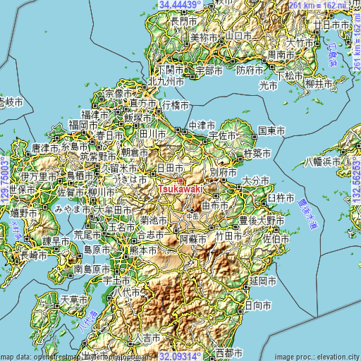
These maps also provides idea of topography and contour of this city, they are displayed at different zoom levels. More info about maps, scale and edge coordinates you can find below images.
| \ | Map #1 | Map #2 | Topo.Map |
| Scale [m] | 306..965 m | 253..1128 m | × |
| Scale [ft] | 1004..3166 ft | 830..3701 ft | × |
| Average | 472 m = 1549 ft | 559 m = 1834 ft | × |
| Width | 8.17 km = 5.1 mi | 16.34 km = 10.2 mi | 261.4 km = 162.4 mi |
| Height | 8.17 km = 5.1 mi | 16.34 km = 10.2 mi | 261.4 km = 162.4 mi |
| ↑Max Latitude | 33.313412° | 33.350128° | 34.44439° |
| Latitude at center | 33.27668° | 33.27668° | 33.27668° |
| ↓Min Latitude | 33.239933° | 33.20317° | 32.09314° |
| ← Min Longitude | 131.112335° | 131.068389° | 129.75003° |
| Longitude center | 131.15628° | 131.15628° | 131.15628° |
| →Max Longitude | 131.200225° | 131.244171° | 132.56253° |
Nearby cities:
Cities around Tsukawaki sort by population:
• Beppu elevation 22 m
31.7 km,  89°
89°
• Nakatsu 7 m
35.9 km,  4°
4°
• Hita 90 m
20.6 km,  283°
283°
• Aso 520 m
38.4 km,  190°
190°
• Hiji 23 m
36.3 km,  73°
73°
• Buzen 20 m
37.3 km,  356°
356°
• Yoshitomi 6 m
36.3 km, 2°
• Taketa 311 m
40.4 km,  150°
150°
• Ukiha 27 m
38.8 km, 283°
• Usa 183 m
24.7 km,  42°
42°
• Yufu 421 m
22.5 km,  113°
113°
• Nakatsu 205 m
20.7 km, 356°
Multilingual:
 En español:
Tsukawaki elevación 336 m.
 En France:
Tsukawaki élévation 336 m.
 Auf Deutsch:
Tsukawaki höhe über dem Meeresspiegel ist 336 m.

Sources and notes:
- [note 1] Map square and city borders are not equal. Map elevation data is calculated only from area inside that square.
- [src 1] Elevation data from geonames database provided with same terms of usage.
- [src 2] The elevation map of Tsukawaki is generated using elevation data from NASA's 3 arcsec (90m) resolution SRTM data.
- [src 3] Base (background) map © OpenStreetMap contributors tiles are generated by Geofabrik and OpenTopoMap.
Copyright & License:
This Tsukawaki Elevation Map is licensed under CC BY-SA. You may reuse any part from this page, if you give a proper credit by linking to this URL:
 More info on terms of use page.