Tsuyama elevation
Tsuyama (Okayama, Tsuyama-shi), Japan elevation is 97 meters and Tsuyama elevation in feet is 318 ft above sea level [src 1]. Tsuyama is a seat of a second-order administrative division (feature code) with elevation that is 12 meters (39 ft) bigger than average city elevation in Japan.
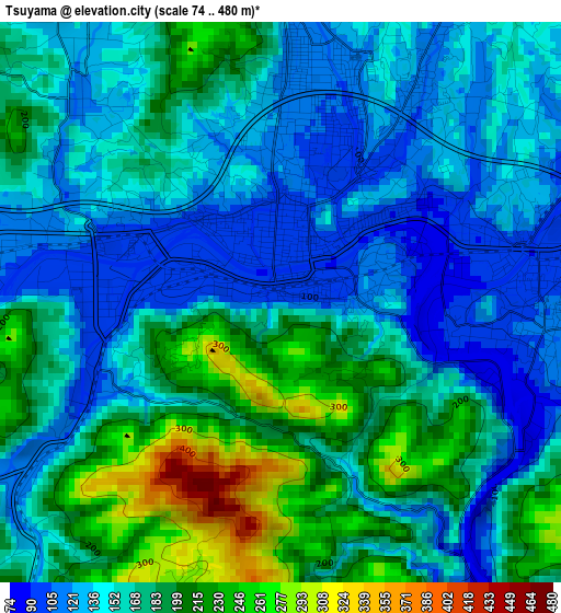
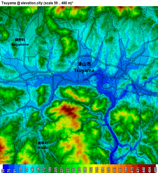
Below is the Elevation map of Tsuyama, which displays elevation range with different colors. Scale of the first map is from 74 to 480 m (243 to 1575 ft) with average elevation of 165.2 meters (=542 ft) [note 1]
These maps also provides idea of topography and contour of this city, they are displayed at different zoom levels. More info about maps, scale and edge coordinates you can find below images.
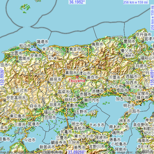
| \ | Map #1 | Map #2 | Topo.Map |
| Scale [m] | 74..480 m | 59..480 m | × |
| Scale [ft] | 243..1575 ft | 194..1575 ft | × |
| Average | 165.2 m = 542 ft | 176.7 m = 580 ft | × |
| Width | 8 km = 5 mi | 16 km = 9.9 mi | 256 km = 159.1 mi |
| Height | 8 km = 5 mi | 16 km = 9.9 mi | 256 km = 159.1 mi |
| ↑Max Latitude | 35.088117° | 35.124068° | 36.1952° |
| Latitude at center | 35.05215° | 35.05215° | 35.05215° |
| ↓Min Latitude | 35.016167° | 34.980168° | 33.89288° |
| ← Min Longitude | 133.954905° | 133.910959° | 132.5926° |
| Longitude center | 133.99885° | 133.99885° | 133.99885° |
| →Max Longitude | 134.042795° | 134.086741° | 135.4051° |
Nearby cities:
Cities around Tsuyama sort by population:
• Okayama elevation 5 m
45.1 km,  187°
187°
• Sōja 19 m
47.6 km,  208°
208°
• Kariya 5 m
48.7 km,  133°
133°
• Kurayoshi 20 m
45.5 km,  338°
338°
• Takahashi 66 m
45.9 km,  229°
229°
• Niimi 193 m
49.1 km,  261°
261°
• Ako 2 m
47 km, 133°
• Setouchi 8 m
45.6 km,  163°
163°
• Bizen 284 m
36.6 km,  143°
143°
• Akaiwa 47 m
27 km,  175°
175°
• Maniwa 222 m
26.1 km,  283°
283°
• Mimasaka 196 m
20.6 km,  93°
93°
Multilingual:
 En español:
Tsuyama elevación 97 m.
 En France:
Tsuyama élévation 97 m.


Sources and notes:
- [note 1] Map square and city borders are not equal. Map elevation data is calculated only from area inside that square.
- [src 1] Elevation data from geonames database provided with same terms of usage.
- [src 2] The elevation map of Tsuyama is generated using elevation data from NASA's 3 arcsec (90m) resolution SRTM data.
- [src 3] Base (background) map © OpenStreetMap contributors tiles are generated by Geofabrik and OpenTopoMap.
Copyright & License:
This Tsuyama Elevation Map is licensed under CC BY-SA. You may reuse any part from this page, if you give a proper credit by linking to this URL:
 More info on terms of use page.