Yoshino-chō elevation
Yoshino-chō (Nara, Yoshino-gun), Japan elevation is 165 meters and Yoshino-chō elevation in feet is 541 ft above sea level [src 1]. Yoshino-chō is a populated place (feature code) with elevation that is 80 meters (262 ft) bigger than average city elevation in Japan.
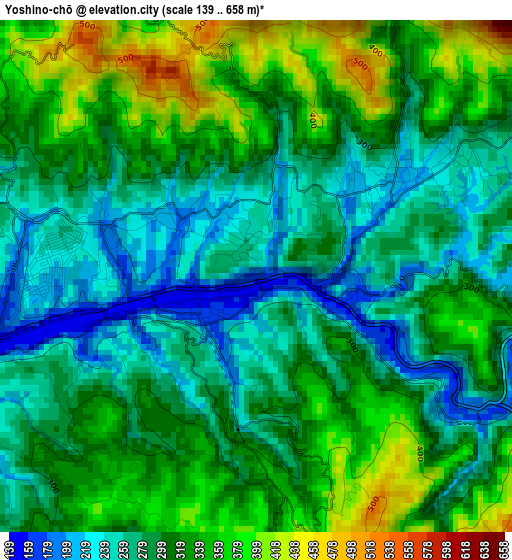
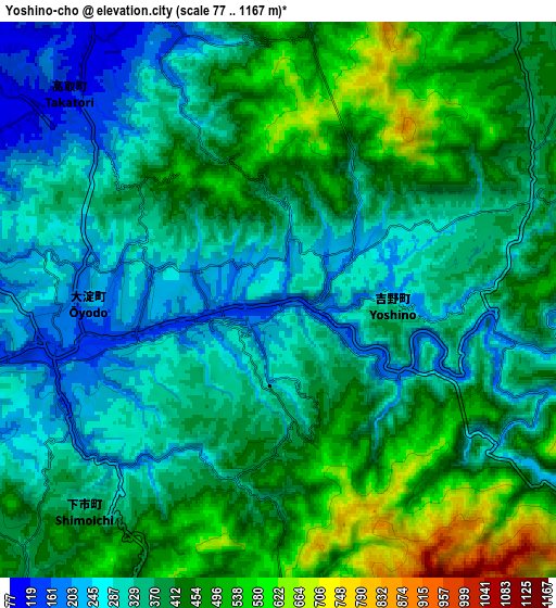
Below is the Elevation map of Yoshino-chō, which displays elevation range with different colors. Scale of the first map is from 139 to 658 m (456 to 2159 ft) with average elevation of 306.2 meters (=1005 ft) [note 1]
These maps also provides idea of topography and contour of this city, they are displayed at different zoom levels. More info about maps, scale and edge coordinates you can find below images.
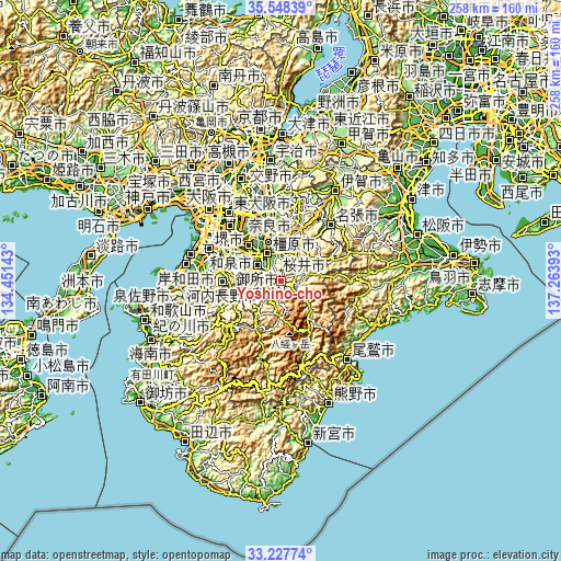
| \ | Map #1 | Map #2 | Topo.Map |
| Scale [m] | 139..658 m | 77..1167 m | × |
| Scale [ft] | 456..2159 ft | 253..3829 ft | × |
| Average | 306.2 m = 1005 ft | 380 m = 1247 ft | × |
| Width | 8.06 km = 5 mi | 16.13 km = 10 mi | 258 km = 160.3 mi |
| Height | 8.06 km = 5 mi | 16.13 km = 10 mi | 258 km = 160.3 mi |
| ↑Max Latitude | 34.432364° | 34.468602° | 35.54839° |
| Latitude at center | 34.39611° | 34.39611° | 34.39611° |
| ↓Min Latitude | 34.359841° | 34.323555° | 33.22774° |
| ← Min Longitude | 135.813735° | 135.769789° | 134.45143° |
| Longitude center | 135.85768° | 135.85768° | 135.85768° |
| →Max Longitude | 135.901625° | 135.945571° | 137.26393° |
Nearby cities:
Cities around Yoshino-chō sort by population:
• Kashihara-shi elevation 65 m
13.9 km,  334°
334°
• Tenri 56 m
20.9 km,  353°
353°
• Sakurai 108 m
11.6 km,  356°
356°
• Hashimoto 79 m
23.8 km,  248°
248°
• Gojō 98 m
15.4 km, 250°
• Gose 105 m
12.9 km,  297°
297°
• Tawaramoto 48 m
18.6 km,  341°
341°
• Haibara-akanedai 345 m
17.4 km,  29°
29°
• Kashiba 58 m
20.6 km,  318°
318°
• Katsuragi 270 m
17.8 km, 304°
• Yamato-Takada 56 m
16.6 km, 323°
• Ōuda 372 m
10.5 km,  41°
41°
Multilingual:
 En español:
Yoshino-chō elevación 165 m.
 En France:
Yoshino-chō élévation 165 m.
 Auf Deutsch:
Yoshino-chō höhe über dem Meeresspiegel ist 165 m.

Sources and notes:
- [note 1] Map square and city borders are not equal. Map elevation data is calculated only from area inside that square.
- [src 1] Elevation data from geonames database provided with same terms of usage.
- [src 2] The elevation map of Yoshino-chō is generated using elevation data from NASA's 3 arcsec (90m) resolution SRTM data.
- [src 3] Base (background) map © OpenStreetMap contributors tiles are generated by Geofabrik and OpenTopoMap.
Copyright & License:
This Yoshino-chō Elevation Map is licensed under CC BY-SA. You may reuse any part from this page, if you give a proper credit by linking to this URL:
 More info on terms of use page.