Al Fayşalīyah elevation
Al Fayşalīyah (Madaba), Jordan elevation is 811 meters and Al Fayşalīyah elevation in feet is 2661 ft above sea level [src 1]. Al Fayşalīyah is a seat of a third-order administrative division (feature code) with elevation that is 119 meters (390 ft) bigger than average city elevation in Jordan.
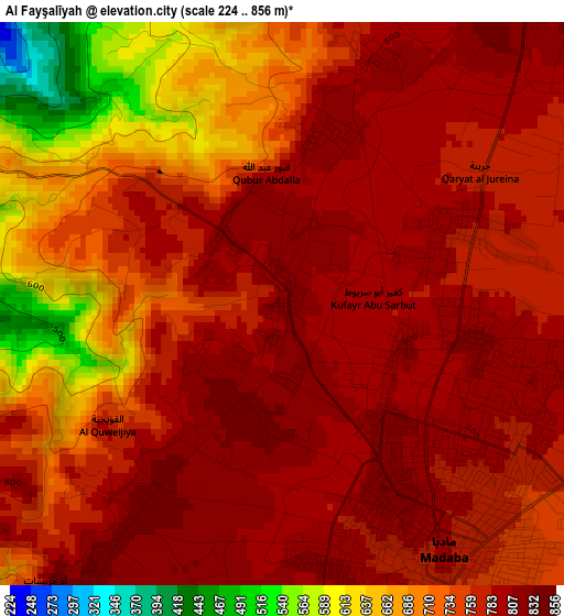
Below is the Elevation map of Al Fayşalīyah, which displays elevation range with different colors. Scale of the first map is from 224 to 856 m (735 to 2808 ft) with average elevation of 749 meters (=2457 ft) [note 1]
These maps also provides idea of topography and contour of this city, they are displayed at different zoom levels. More info about maps, scale and edge coordinates you can find below images.
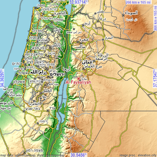
| \ | Map #1 | Topo.Map |
| Scale [m] | 224..856 m | × |
| Scale [ft] | 735..2808 ft | × |
| Average | 749 m = 2457 ft | × |
| Width | 8.31 km = 5.2 mi | 265.9 km = 165.2 mi |
| Height | 8.31 km = 5.2 mi | 265.9 km = 165.2 mi |
| ↑Max Latitude | 31.786452° | 32.93714° |
| Latitude at center | 31.74909° | 31.74909° |
| ↓Min Latitude | 31.711713° | 30.5456° |
| ← Min Longitude | 35.725275° | 34.36297° |
| Longitude center | 35.76922° | 35.76922° |
| →Max Longitude | 35.813165° | 37.17547° |
Nearby cities:
Cities around Al Fayşalīyah sort by population:
• Mādabā elevation 790 m
4.4 km,  147°
147°
• Umm as Summāq 934 m
17.2 km,  27°
27°
• Jāwā 889 m
19.8 km,  54°
54°
• Ḩayy al Bunayyāt 925 m
19.6 km, 33°
• Al Jīzah 717 m
18.5 km,  107°
107°
• Ash Shūnah al Janūbīyah -233 m
21.3 km,  317°
317°
• Mulayḩ 685 m
18.6 km,  168°
168°
• Nā‘ūr 797 m
14.9 km,  20°
20°
• Umm al Basātīn 846 m
13.3 km, 50°
• Mā‘īn 845 m
8.4 km,  204°
204°
• Ḩisbān 851 m
6.7 km,  35°
35°
• Juraynah 794 m
2.7 km,  63°
63°
Multilingual:
 En español:
Al Fayşalīyah elevación 811 m.
 En France:
Al Fayşalīyah élévation 811 m.
 Auf Deutsch:
Al Fayşalīyah höhe über dem Meeresspiegel ist 811 m.

Sources and notes:
- [note 1] Map square and city borders are not equal. Map elevation data is calculated only from area inside that square.
- [src 1] Elevation data from geonames database provided with same terms of usage.
- [src 2] The elevation map of Al Fayşalīyah is generated using elevation data from NASA's 3 arcsec (90m) resolution SRTM data.
- [src 3] Base (background) map © OpenStreetMap contributors tiles are generated by Geofabrik and OpenTopoMap.
Copyright & License:
This Al Fayşalīyah Elevation Map is licensed under CC BY-SA. You may reuse any part from this page, if you give a proper credit by linking to this URL:
 More info on terms of use page.