Coleyville elevation
Coleyville (Manchester), Jamaica elevation is 944 meters and Coleyville elevation in feet is 3097 ft above sea level [src 1]. Coleyville is a populated place (feature code) with elevation that is 729 meters (2392 ft) bigger than average city elevation in Jamaica.
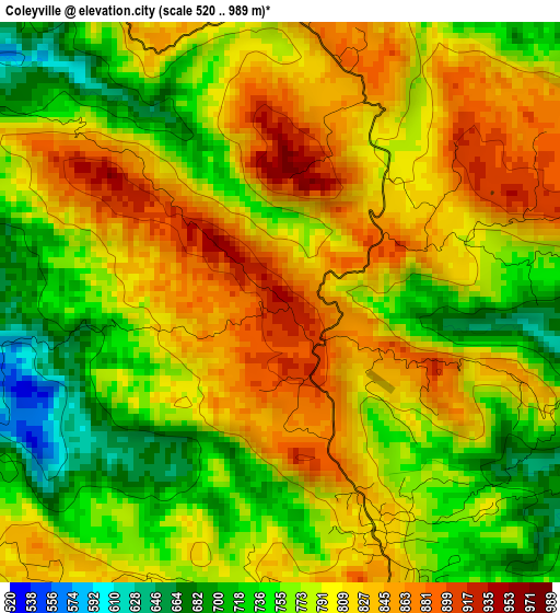
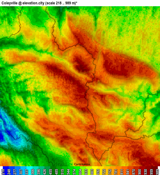
Below is the Elevation map of Coleyville, which displays elevation range with different colors. Scale of the first map is from 520 to 989 m (1706 to 3245 ft) with average elevation of 789.9 meters (=2592 ft) [note 1]
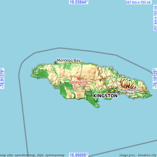
These maps also provides idea of topography and contour of this city, they are displayed at different zoom levels. More info about maps, scale and edge coordinates you can find below images.
| \ | Map #1 | Map #2 | Topo.Map |
| Scale [m] | 520..989 m | 218..989 m | × |
| Scale [ft] | 1706..3245 ft | 715..3245 ft | × |
| Average | 789.9 m = 2592 ft | 699.1 m = 2294 ft | × |
| Width | 9.28 km = 5.8 mi | 18.57 km = 11.5 mi | 297 km = 184.5 mi |
| Height | 9.28 km = 5.8 mi | 18.57 km = 11.5 mi | 297.1 km = 184.6 mi |
| ↑Max Latitude | 18.24957° | 18.2913° | 19.53844° |
| Latitude at center | 18.20783° | 18.20783° | 18.20783° |
| ↓Min Latitude | 18.16608° | 18.12432° | 16.86698° |
| ← Min Longitude | -77.551485° | -77.595431° | -78.91379° |
| Longitude center | -77.50754° | -77.50754° | -77.50754° |
| →Max Longitude | -77.463595° | -77.419649° | -76.10129° |
Nearby cities:
Cities around Coleyville sort by population:
• Mandeville elevation 609 m
18.5 km,  179°
179°
• Porus 128 m
21.7 km,  152°
152°
• Albert Town 622 m
10.3 km,  339°
339°
• Williamsfield 427 m
16.3 km,  164°
164°
• Balaclava 230 m
14.9 km,  254°
254°
• Siloah 141 m
21.2 km,  257°
257°
• Kellits 721 m
25.6 km,  101°
101°
• Limit 856 m
7.2 km, 147°
• Alexandria 608 m
19.7 km,  55°
55°
• Ulster Spring 444 m
12 km,  353°
353°
• Quickstep 685 m
15.8 km,  292°
292°
• Rock Spring 607 m
11.4 km, 335°
Multilingual:
 En español:
Coleyville elevación 944 m.
 En France:
Coleyville élévation 944 m.
 Auf Deutsch:
Coleyville höhe über dem Meeresspiegel ist 944 m.

Sources and notes:
- [note 1] Map square and city borders are not equal. Map elevation data is calculated only from area inside that square.
- [src 1] Elevation data from geonames database provided with same terms of usage.
- [src 2] The elevation map of Coleyville is generated using elevation data from NASA's 3 arcsec (90m) resolution SRTM data.
- [src 3] Base (background) map © OpenStreetMap contributors tiles are generated by Geofabrik and OpenTopoMap.
Copyright & License:
This Coleyville Elevation Map is licensed under CC BY-SA. You may reuse any part from this page, if you give a proper credit by linking to this URL:
 More info on terms of use page.