Mandeville elevation
Mandeville (Manchester, Mandeville Proper), Jamaica elevation is 609 meters and Mandeville elevation in feet is 1998 ft above sea level [src 1]. Mandeville is a seat of a first-order administrative division (feature code) with elevation that is 394 meters (1293 ft) bigger than average city elevation in Jamaica.
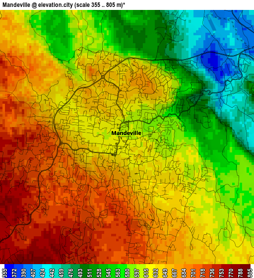
Below is the Elevation map of Mandeville, which displays elevation range with different colors. Scale of the first map is from 355 to 805 m (1165 to 2641 ft) with average elevation of 622.4 meters (=2042 ft) [note 1]
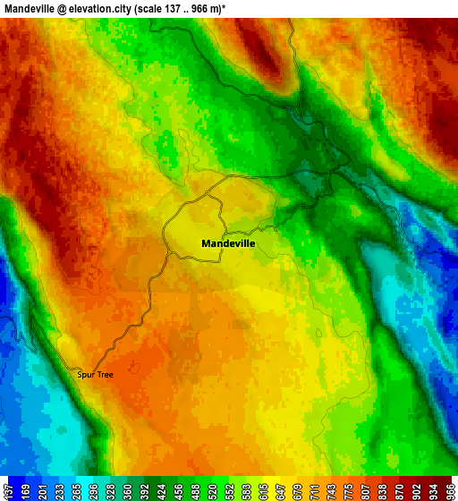
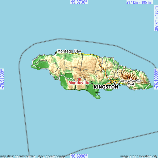
These maps also provides idea of topography and contour of this city, they are displayed at different zoom levels. More info about maps, scale and edge coordinates you can find below images.
| \ | Map #1 | Map #2 | Topo.Map |
| Scale [m] | 355..805 m | 137..966 m | × |
| Scale [ft] | 1165..2641 ft | 449..3169 ft | × |
| Average | 622.4 m = 2042 ft | 599 m = 1965 ft | × |
| Width | 9.29 km = 5.8 mi | 18.58 km = 11.5 mi | 297.3 km = 184.7 mi |
| Height | 9.29 km = 5.8 mi | 18.58 km = 11.5 mi | 297.3 km = 184.7 mi |
| ↑Max Latitude | 18.08346° | 18.125229° | 19.3736° |
| Latitude at center | 18.04168° | 18.04168° | 18.04168° |
| ↓Min Latitude | 17.99989° | 17.958091° | 16.6996° |
| ← Min Longitude | -77.551085° | -77.595031° | -78.91339° |
| Longitude center | -77.50714° | -77.50714° | -77.50714° |
| →Max Longitude | -77.463195° | -77.419249° | -76.10089° |
Nearby cities:
Cities around Mandeville sort by population:
• Santa Cruz elevation 13 m
20.3 km,  273°
273°
• Bull Savanna 270 m
19.3 km,  207°
207°
• Porus 128 m
10.1 km,  93°
93°
• Coleyville 944 m
18.5 km,  359°
359°
• Malvern 662 m
22 km,  247°
247°
• Williamsfield 427 m
5.1 km,  56°
56°
• Balaclava 230 m
20.5 km,  315°
315°
• Southfield 582 m
24.1 km,  224°
224°
• Nain 192 m
13.4 km,  230°
230°
• Limit 856 m
12.9 km,  17°
17°
• Alligator Pond 38 m
20.2 km,  198°
198°
• Mocho 469 m
18.7 km, 90°
Multilingual:
 En español:
Mandeville elevación 609 m.
 En France:
Mandeville élévation 609 m.
 Auf Deutsch:
Mandeville höhe über dem Meeresspiegel ist 609 m.

Sources and notes:
- [note 1] Map square and city borders are not equal. Map elevation data is calculated only from area inside that square.
- [src 1] Elevation data from geonames database provided with same terms of usage.
- [src 2] The elevation map of Mandeville is generated using elevation data from NASA's 3 arcsec (90m) resolution SRTM data.
- [src 3] Base (background) map © OpenStreetMap contributors tiles are generated by Geofabrik and OpenTopoMap.
Copyright & License:
This Mandeville Elevation Map is licensed under CC BY-SA. You may reuse any part from this page, if you give a proper credit by linking to this URL:
 More info on terms of use page.