Falmouth elevation
Falmouth (Trelawny), Jamaica elevation is 5 meters and Falmouth elevation in feet is 16 ft above sea level [src 1]. Falmouth is a seat of a first-order administrative division (feature code) with elevation that is 210 meters (689 ft) smaller than average city elevation in Jamaica.
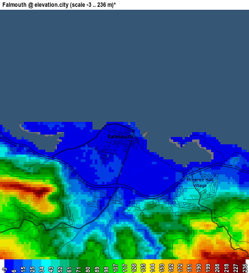
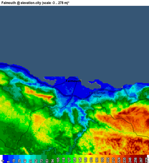
Below is the Elevation map of Falmouth, which displays elevation range with different colors. Scale of the first map is from -3 to 236 m (-10 to 774 ft) with average elevation of 55.9 meters (=183 ft) [note 1]
These maps also provides idea of topography and contour of this city, they are displayed at different zoom levels. More info about maps, scale and edge coordinates you can find below images.
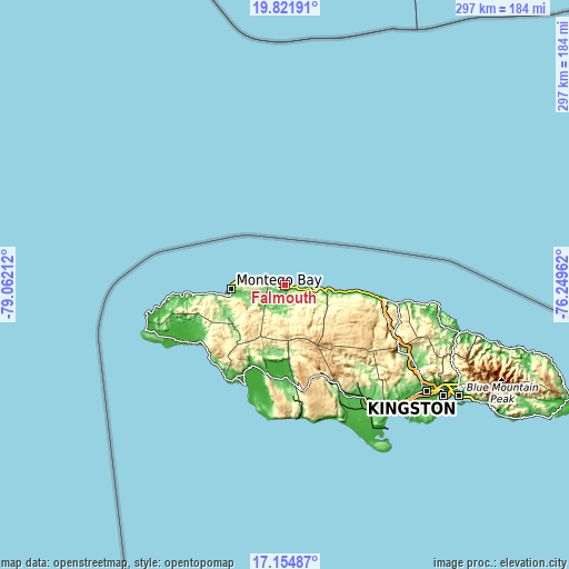
| \ | Map #1 | Map #2 | Topo.Map |
| Scale [m] | -3..236 m | -3..278 m | × |
| Scale [ft] | -10..774 ft | -10..912 ft | × |
| Average | 55.9 m = 183 ft | 112.7 m = 370 ft | × |
| Width | 9.27 km = 5.8 mi | 18.54 km = 11.5 mi | 296.5 km = 184.2 mi |
| Height | 9.27 km = 5.8 mi | 18.54 km = 11.5 mi | 296.6 km = 184.3 mi |
| ↑Max Latitude | 18.535251° | 18.576912° | 19.82191° |
| Latitude at center | 18.49358° | 18.49358° | 18.49358° |
| ↓Min Latitude | 18.451899° | 18.410208° | 17.15487° |
| ← Min Longitude | -77.699815° | -77.743761° | -79.06212° |
| Longitude center | -77.65587° | -77.65587° | -77.65587° |
| →Max Longitude | -77.611925° | -77.567979° | -76.24962° |
Nearby cities:
Cities around Falmouth sort by population:
• Montego Bay elevation 12 m
27.8 km,  264°
264°
• Runaway Bay 13 m
34 km,  96°
96°
• Anchovy 214 m
30.5 km,  252°
252°
• Cambridge 181 m
32.9 km,  232°
232°
• Albert Town 622 m
25.2 km,  151°
151°
• Maroon Town 441 m
22.2 km,  221°
221°
• Wakefield 94 m
11.4 km, 217°
• Discovery Bay 29 m
27.3 km, 98°
• Duncans 130 m
12.9 km, 102°
• Ulster Spring 444 m
24.5 km,  144°
144°
• Quickstep 685 m
25.7 km,  177°
177°
• Rock Spring 607 m
24 km, 153°
Multilingual:
 En español:
Falmouth elevación 5 m.
 En France:
Falmouth élévation 5 m.


Sources and notes:
- [note 1] Map square and city borders are not equal. Map elevation data is calculated only from area inside that square.
- [src 1] Elevation data from geonames database provided with same terms of usage.
- [src 2] The elevation map of Falmouth is generated using elevation data from NASA's 3 arcsec (90m) resolution SRTM data.
- [src 3] Base (background) map © OpenStreetMap contributors tiles are generated by Geofabrik and OpenTopoMap.
Copyright & License:
This Falmouth Elevation Map is licensed under CC BY-SA. You may reuse any part from this page, if you give a proper credit by linking to this URL:
 More info on terms of use page.