Montego Bay elevation
Montego Bay (St. James, Down Town Montego Bay), Jamaica elevation is 12 meters and Montego Bay elevation in feet is 39 ft above sea level [src 1]. Montego Bay is a seat of a first-order administrative division (feature code) with elevation that is 203 meters (666 ft) smaller than average city elevation in Jamaica.
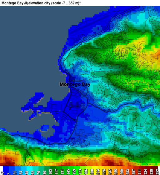
Below is the Elevation map of Montego Bay, which displays elevation range with different colors. Scale of the first map is from -7 to 352 m (-23 to 1155 ft) with average elevation of 86.8 meters (=285 ft) [note 1]
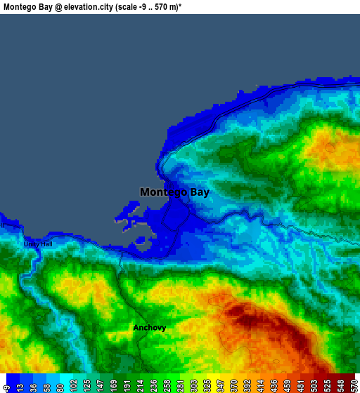
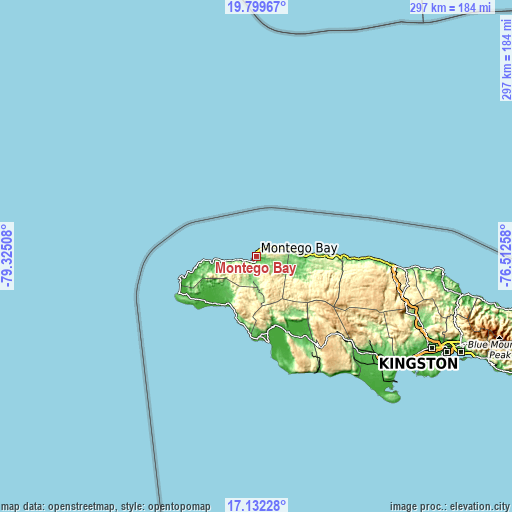
These maps also provides idea of topography and contour of this city, they are displayed at different zoom levels. More info about maps, scale and edge coordinates you can find below images.
| \ | Map #1 | Map #2 | Topo.Map |
| Scale [m] | -7..352 m | -9..570 m | × |
| Scale [ft] | -23..1155 ft | -30..1870 ft | × |
| Average | 86.8 m = 285 ft | 191.8 m = 629 ft | × |
| Width | 9.27 km = 5.8 mi | 18.54 km = 11.5 mi | 296.6 km = 184.3 mi |
| Height | 9.27 km = 5.8 mi | 18.54 km = 11.5 mi | 296.6 km = 184.3 mi |
| ↑Max Latitude | 18.512836° | 18.554503° | 19.79967° |
| Latitude at center | 18.47116° | 18.47116° | 18.47116° |
| ↓Min Latitude | 18.429474° | 18.387777° | 17.13228° |
| ← Min Longitude | -77.962775° | -78.006721° | -79.32508° |
| Longitude center | -77.91883° | -77.91883° | -77.91883° |
| →Max Longitude | -77.874885° | -77.830939° | -76.51258° |
Nearby cities:
Cities around Montego Bay sort by population:
• Falmouth elevation 5 m
27.8 km,  84°
84°
• Lucea 12 m
27 km,  265°
265°
• Sandy Bay 23 m
16.5 km,  261°
261°
• Anchovy 214 m
6.9 km,  191°
191°
• Cambridge 181 m
17.6 km,  174°
174°
• Maroon Town 441 m
19.2 km,  137°
137°
• Bethel Town 292 m
19.9 km, 189°
• Wakefield 94 m
21.8 km,  107°
107°
• Petersfield 50 m
28.3 km,  214°
214°
• Darliston 422 m
26.7 km, 193°
• Cascade 329 m
21.1 km,  247°
247°
• Mt Peto 328 m
17.3 km,  226°
226°
Multilingual:
 En español:
Bahía Montego elevación 12 m.
 En France:
Montego Bay élévation 12 m.
 Auf Deutsch:
Montego Bay höhe über dem Meeresspiegel ist 12 m.

Sources and notes:
- [note 1] Map square and city borders are not equal. Map elevation data is calculated only from area inside that square.
- [src 1] Elevation data from geonames database provided with same terms of usage.
- [src 2] The elevation map of Montego Bay is generated using elevation data from NASA's 3 arcsec (90m) resolution SRTM data.
- [src 3] Base (background) map © OpenStreetMap contributors tiles are generated by Geofabrik and OpenTopoMap.
Copyright & License:
This Montego Bay Elevation Map is licensed under CC BY-SA. You may reuse any part from this page, if you give a proper credit by linking to this URL:
 More info on terms of use page.