Falerna Scalo elevation
Falerna Scalo (Calabria, Provincia di Catanzaro), Italy elevation is 20 meters and Falerna Scalo elevation in feet is 66 ft above sea level [src 1]. Falerna Scalo is a populated place (feature code) with elevation that is 302 meters (991 ft) smaller than average city elevation in Italy.
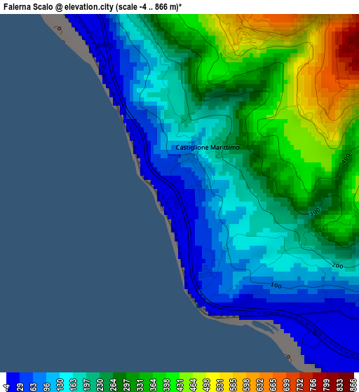
Below is the Elevation map of Falerna Scalo, which displays elevation range with different colors. Scale of the first map is from -4 to 866 m (-13 to 2841 ft) with average elevation of 240.8 meters (=790 ft) [note 1]
These maps also provides idea of topography and contour of this city, they are displayed at different zoom levels. More info about maps, scale and edge coordinates you can find below images.
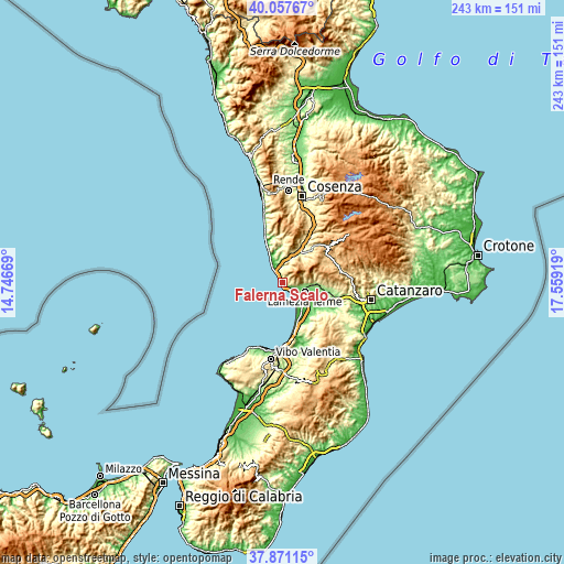
| \ | Map #1 | Topo.Map |
| Scale [m] | -4..866 m | × |
| Scale [ft] | -13..2841 ft | × |
| Average | 240.8 m = 790 ft | × |
| Width | 7.6 km = 4.7 mi | 243.1 km = 151.1 mi |
| Height | 7.6 km = 4.7 mi | 243.1 km = 151.1 mi |
| ↑Max Latitude | 39.007007° | 40.05767° |
| Latitude at center | 38.97285° | 38.97285° |
| ↓Min Latitude | 38.938677° | 37.87115° |
| ← Min Longitude | 16.108995° | 14.74669° |
| Longitude center | 16.15294° | 16.15294° |
| →Max Longitude | 16.196885° | 17.55919° |
Nearby cities:
Cities around Falerna Scalo sort by population:
• Lamezia Terme elevation 165 m
13.6 km,  94°
94°
• Sambiase 184 m
11.3 km, 93°
• Santa Eufemia Lamezia 23 m
10.4 km,  124°
124°
• Campora San Giovanni 28 m
11.7 km,  334°
334°
• Nocera Scalo 5 m
5.5 km, 329°
• San Mango d'Aquino 452 m
10.3 km,  19°
19°
• Gizzeria 558 m
4.7 km,  79°
79°
• Nocera Terinese 367 m
7 km,  10°
10°
• Falerna 588 m
3.7 km,  25°
25°
• Martirano Lombardo 529 m
13.2 km, 31°
• Serra d'Aiello 366 m
13.2 km,  349°
349°
• Cleto 266 m
13.1 km,  2°
2°
Multilingual:
 En español:
Falerna Scalo elevación 20 m.
 En France:
Falerna Scalo élévation 20 m.
 Auf Deutsch:
Falerna Scalo höhe über dem Meeresspiegel ist 20 m.

Sources and notes:
- [note 1] Map square and city borders are not equal. Map elevation data is calculated only from area inside that square.
- [src 1] Elevation data from geonames database provided with same terms of usage.
- [src 2] The elevation map of Falerna Scalo is generated using elevation data from NASA's 3 arcsec (90m) resolution SRTM data.
- [src 3] Base (background) map © OpenStreetMap contributors tiles are generated by Geofabrik and OpenTopoMap.
Copyright & License:
This Falerna Scalo Elevation Map is licensed under CC BY-SA. You may reuse any part from this page, if you give a proper credit by linking to this URL:
 More info on terms of use page.