Melia elevation
Melia (Sicily, Messina), Italy elevation is 412 meters and Melia elevation in feet is 1352 ft above sea level [src 1]. Melia is a seat of a third-order administrative division (feature code) with elevation that is 90 meters (295 ft) bigger than average city elevation in Italy.
Below is the Elevation map of Melia, which displays elevation range with different colors. Scale of the first map is from 2 to 991 m (7 to 3251 ft) with average elevation of 512.9 meters (=1683 ft) [note 1]
These maps also provides idea of topography and contour of this city, they are displayed at different zoom levels. More info about maps, scale and edge coordinates you can find below images.
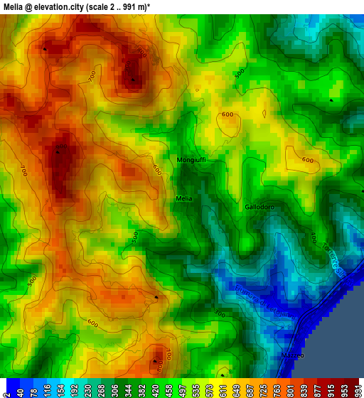
| \ | Map #1 | Topo.Map |
| Scale [m] | 2..991 m | × |
| Scale [ft] | 7..3251 ft | × |
| Average | 512.9 m = 1683 ft | × |
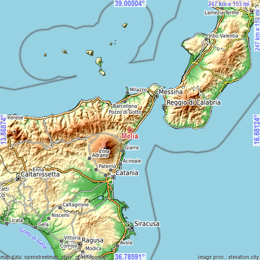
| Width | 7.71 km = 4.8 mi | 246.7 km = 153.3 mi |
| Height | 7.71 km = 4.8 mi | 246.7 km = 153.3 mi |
| ↑Max Latitude | 37.938507° | 39.00504° |
| Latitude at center | 37.90384° | 37.90384° |
| ↓Min Latitude | 37.869157° | 36.78591° |
| ← Min Longitude | 15.231045° | 13.86874° |
| Longitude center | 15.27499° | 15.27499° |
| →Max Longitude | 15.318935° | 16.68124° |
Nearby cities:
Cities around Melia sort by population:
• Taormina elevation 215 m
5.7 km,  168°
168°
• Gaggi 110 m
6.8 km,  224°
224°
• Letojanni 17 m
3.8 km,  132°
132°
• Graniti 316 m
4.7 km,  250°
250°
• Sant'Alessio Siculo 9 m
7 km,  70°
70°
• Limina 592 m
4.1 km,  355°
355°
• Mongiuffi Melia 416 m
0.1 km,  146°
146°
• Forza d'Agrò 365 m
5.3 km,  76°
76°
• Castelmola 496 m
5.1 km,  177°
177°
• Casalvecchio Siculo 421 m
7.4 km,  35°
35°
• Gallodoro 381 m
1.6 km,  96°
96°
• Roccafiorita 734 m
3.1 km,  347°
347°
Multilingual:
 En español:
Melia elevación 412 m.
 En France:
Melia élévation 412 m.


Sources and notes:
- [note 1] Map square and city borders are not equal. Map elevation data is calculated only from area inside that square.
- [src 1] Elevation data from geonames database provided with same terms of usage.
- [src 2] The elevation map of Melia is generated using elevation data from NASA's 3 arcsec (90m) resolution SRTM data.
- [src 3] Base (background) map © OpenStreetMap contributors tiles are generated by Geofabrik and OpenTopoMap.
Copyright & License:
This Melia Elevation Map is licensed under CC BY-SA. You may reuse any part from this page, if you give a proper credit by linking to this URL:
 More info on terms of use page.